The DE13 7 postcode sector is within the county of Staffordshire.
Did you know? According to the 2021 Census, the DE13 7 postcode sector is home to a bustling 4,067 residents!
Given that each sector allows for 400 unique postcode combinations. Letters C, I, K, M, O and V are not allowed in the last two letters of a postcode. With 114 postcodes already in use, this leaves 286 units available.
The largest settlements in the DE13 7 postal code are Alrewas and Kings Bromley.
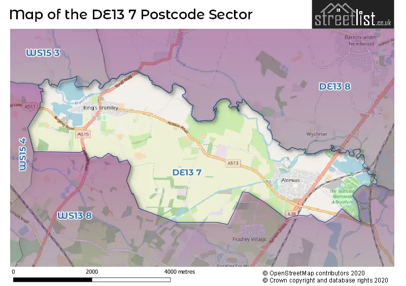
The DE13 7 Postcode shares a border with DE13 8 (Barton Under Needwood, Yoxall, Newborough), WS13 8 (LICHFIELD, Fradley, Streethay), WS15 3 (Abbots Bromley, RUGELEY, Hill Ridware) and WS15 4 (RUGELEY, Armitage, Handsacre).
The sector is within the post town of BURTON-ON-TRENT.
DE13 7 is a postcode sector within the DE13 postcode district which is within the DE Derby postcode area.
The Royal Mail delivery office for the DE13 7 postal sector is the Burton On Trent Delivery Office.
The area of the DE13 7 postcode sector is 7.28 square miles which is 18.86 square kilometres or 4,660.49 square acres.
The DE13 7 postcode sector is crossed by the A38 Major A road.
Waterways within the DE13 7 postcode sector include the Coventry Canal, Trent & Mersey Canal, River Trent, Bagnall Lock.

Map of the DE13 7 Postcode Sector
Explore the DE13 7 postcode sector by using our free interactive map.
| D | E | 1 | 3 | - | 7 | X | X |
| D | E | 1 | 3 | Space | 7 | Letter | Letter |
Official List of Streets
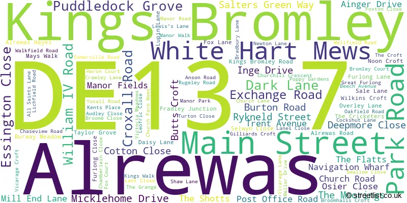
Alrewas (65 Streets)
Kings Bromley (30 Streets)
Unofficial Streets or Alternative Spellings
Elford
BURTON ROADLICHFIELD
BARLEY GREEN LANEBromley Hayes
LICHFIELD ROADHanch
SHAW LANEWeather Forecast for DE13 7
Press Button to Show Forecast for Yoxall
| Time Period | Icon | Description | Temperature | Rain Probability | Wind |
|---|---|---|---|---|---|
| 06:00 to 09:00 | Cloudy | 4.0°C (feels like 2.0°C) | 4.00% | ENE 4 mph | |
| 09:00 to 12:00 | Cloudy | 7.0°C (feels like 5.0°C) | 5.00% | E 7 mph | |
| 12:00 to 15:00 | Overcast | 9.0°C (feels like 8.0°C) | 10.00% | E 4 mph | |
| 15:00 to 18:00 | Cloudy | 10.0°C (feels like 9.0°C) | 8.00% | E 4 mph | |
| 18:00 to 21:00 | Cloudy | 9.0°C (feels like 7.0°C) | 10.00% | ENE 7 mph | |
| 21:00 to 00:00 | Partly cloudy (night) | 6.0°C (feels like 4.0°C) | 8.00% | ENE 7 mph |
Press Button to Show Forecast for Yoxall
| Time Period | Icon | Description | Temperature | Rain Probability | Wind |
|---|---|---|---|---|---|
| 00:00 to 03:00 | Partly cloudy (night) | 4.0°C (feels like 2.0°C) | 8.00% | ENE 7 mph | |
| 03:00 to 06:00 | Cloudy | 4.0°C (feels like 1.0°C) | 12.00% | ENE 7 mph | |
| 06:00 to 09:00 | Cloudy | 5.0°C (feels like 2.0°C) | 13.00% | ENE 7 mph | |
| 09:00 to 12:00 | Cloudy | 8.0°C (feels like 5.0°C) | 16.00% | ENE 11 mph | |
| 12:00 to 15:00 | Overcast | 9.0°C (feels like 7.0°C) | 23.00% | ENE 11 mph | |
| 15:00 to 18:00 | Light rain | 10.0°C (feels like 8.0°C) | 49.00% | ENE 11 mph | |
| 18:00 to 21:00 | Cloudy | 10.0°C (feels like 7.0°C) | 19.00% | ENE 9 mph | |
| 21:00 to 00:00 | Cloudy | 8.0°C (feels like 5.0°C) | 21.00% | ENE 11 mph |
Press Button to Show Forecast for Yoxall
| Time Period | Icon | Description | Temperature | Rain Probability | Wind |
|---|---|---|---|---|---|
| 00:00 to 03:00 | Overcast | 7.0°C (feels like 4.0°C) | 21.00% | NE 9 mph | |
| 03:00 to 06:00 | Overcast | 7.0°C (feels like 4.0°C) | 24.00% | NE 9 mph | |
| 06:00 to 09:00 | Light rain | 7.0°C (feels like 5.0°C) | 54.00% | NE 9 mph | |
| 09:00 to 12:00 | Heavy rain | 9.0°C (feels like 7.0°C) | 76.00% | NNE 9 mph | |
| 12:00 to 15:00 | Heavy rain | 10.0°C (feels like 8.0°C) | 75.00% | NNE 9 mph | |
| 15:00 to 18:00 | Heavy rain shower (day) | 11.0°C (feels like 9.0°C) | 60.00% | ESE 11 mph | |
| 18:00 to 21:00 | Cloudy | 11.0°C (feels like 9.0°C) | 21.00% | S 9 mph | |
| 21:00 to 00:00 | Partly cloudy (night) | 8.0°C (feels like 6.0°C) | 10.00% | SSW 7 mph |
Schools and Places of Education Within the DE13 7 Postcode Sector
Options Trent Acres School
Other independent special school
Alrewas Road, Burton on Trent, Staffordshire, DE13 7HR
Head: Mrs Melanie Callaghan-Lewis
Ofsted Rating: Outstanding
Inspection: 2023-01-26 (456 days ago)
Website: Visit Options Trent Acres School Website
Phone: 01543473772
Number of Pupils: 92
The Richard Crosse CofE Primary School
Academy converter
Crawley Lane, Burton-on-Trent, Staffordshire, DE13 7JE
Head: Headteacher Emma Bowring
Ofsted Rating: Good
Inspection: 2023-11-15 (163 days ago)
Website: Visit The Richard Crosse CofE Primary School Website
Phone: 01543472245
Number of Pupils: 111
House Prices in the DE13 7 Postcode Sector
| Type of Property | 2018 Average | 2018 Sales | 2017 Average | 2017 Sales | 2016 Average | 2016 Sales | 2015 Average | 2015 Sales |
|---|---|---|---|---|---|---|---|---|
| Detached | £528,396 | 48 | £380,470 | 33 | £440,943 | 45 | £438,964 | 29 |
| Semi-Detached | £258,592 | 25 | £246,217 | 30 | £239,676 | 17 | £209,302 | 23 |
| Terraced | £249,167 | 6 | £250,375 | 8 | £241,000 | 9 | £213,000 | 5 |
| Flats | £0 | 0 | £0 | 0 | £226,000 | 2 | £0 | 0 |
Important Postcodes DE13 7 in the Postcode Sector
DE13 7AS is the postcode for Doctors Surgery, Exchange Road
DE13 7EF is the postcode for Staffordshire County Council, All Saints C of E Primary School, Furlong Close, and All Saints Church Of England Primary School, Furlong Close, Alrewas
DE13 7JE is the postcode for Staffordshire County Council, Richard Crosse C E Primary School, Lichfield Road
| The DE13 7 Sector is within these Local Authorities |
|
|---|---|
| The DE13 7 Sector is within these Counties |
|
| The DE13 7 Sector is within these Water Company Areas |
|
Tourist Attractions within the DE13 7 Postcode Area
We found 1 visitor attractions within the DE13 postcode area
| National Memorial Arboretum |
|---|
| Visitor Centres |
| Heritage / Visitor Centre |
| View National Memorial Arboretum on Google Maps |