The DE21 5 postcode sector is within the county of Derbyshire.
Did you know? According to the 2021 Census, the DE21 5 postcode sector is home to a bustling 3,501 residents!
Given that each sector allows for 400 unique postcode combinations. Letters C, I, K, M, O and V are not allowed in the last two letters of a postcode. With 82 postcodes already in use, this leaves 318 units available.
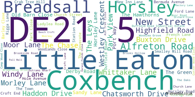
The largest settlement in the DE21 5 postal code is Little Eaton followed by Breadsall, and Horsley.
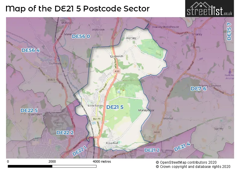
The DE21 5 Postcode shares a border with DE7 6 (West Hallam, Smalley, Morley), DE21 2 (Oakwood), DE21 4 (Chaddesden, DERBY, Oakwood), DE22 2 (Allestree, DERBY, Darley Abbey), DE56 0 (BELPER, Kilburn, Milford), DE22 1 (DERBY, Darley Abbey, Allestree) and DE56 4 (Duffield, Hazelwood).
The sector is within the post town of DERBY.
DE21 5 is a postcode sector within the DE21 postcode district which is within the DE Derby postcode area.
The Royal Mail delivery office for the DE21 5 postal sector is the Derby Town Delivery Office.
The area of the DE21 5 postcode sector is 5.67 square miles which is 14.68 square kilometres or 3,627.14 square acres.
The DE21 5 postcode sector is crossed by the A38 Major A road.
Waterways within the DE21 5 postcode sector include the River Derwent.

Map of the DE21 5 Postcode Sector
Explore the DE21 5 postcode sector by using our free interactive map.
| D | E | 2 | 1 | - | 5 | X | X |
| D | E | 2 | 1 | Space | 5 | Letter | Letter |
Official List of Streets
Coxbench (5 Streets)
Little Eaton (38 Streets)
Breadsall (13 Streets)
Unofficial Streets or Alternative Spellings
Holbrook
PORT WAYHorsley Woodhouse
LADY LEA ROAD ABBEY HILL BEMROSE DRIVE BEMROSE PATH BOTTOM ROAD CAMPFIRE TRACK CHAPEL PATH COXBENCH ROAD DISSUSED BRIDGE GREAT NORTHERN GREENWAY LADY LEA HILL LITTLE EATON ROUNDABOUT MAIN ROAD PRIORY CROFT QUARRY ROAD SPIKES PATH THE ROCKETY TOAD LANE TOP ROAD TOWER ROAD TRAINING ROAD TRIANGLE LINK WATERBOARD ROAD WINDMILL BRIDLEWAYLower Kilburn
TANTS MEADOWMorley
BRACKLEY GATE MANSFIELD ROAD MORLEY ALMSHOUSES LANEDuffield
EATON BANK RIGGA LANEAllestree
FORD LANEWeather Forecast for DE21 5
Press Button to Show Forecast for County Ground Derbyshire C.C.C.
| Time Period | Icon | Description | Temperature | Rain Probability | Wind |
|---|---|---|---|---|---|
| 00:00 to 03:00 | Clear night | 16.0°C (feels like 16.0°C) | 2.00% | E 2 mph | |
| 03:00 to 06:00 | Clear night | 14.0°C (feels like 14.0°C) | 2.00% | SE 4 mph | |
| 06:00 to 09:00 | Cloudy | 14.0°C (feels like 14.0°C) | 8.00% | S 7 mph | |
| 09:00 to 12:00 | Cloudy | 16.0°C (feels like 15.0°C) | 4.00% | S 9 mph | |
| 12:00 to 15:00 | Cloudy | 19.0°C (feels like 17.0°C) | 3.00% | S 11 mph | |
| 15:00 to 18:00 | Cloudy | 21.0°C (feels like 18.0°C) | 4.00% | SSE 13 mph | |
| 18:00 to 21:00 | Cloudy | 19.0°C (feels like 16.0°C) | 6.00% | SSE 11 mph | |
| 21:00 to 00:00 | Cloudy | 16.0°C (feels like 15.0°C) | 9.00% | SE 9 mph |
Press Button to Show Forecast for County Ground Derbyshire C.C.C.
| Time Period | Icon | Description | Temperature | Rain Probability | Wind |
|---|---|---|---|---|---|
| 00:00 to 03:00 | Cloudy | 15.0°C (feels like 14.0°C) | 22.00% | SE 9 mph | |
| 03:00 to 06:00 | Light rain | 14.0°C (feels like 13.0°C) | 59.00% | ESE 9 mph | |
| 06:00 to 09:00 | Light rain | 14.0°C (feels like 12.0°C) | 57.00% | ESE 9 mph | |
| 09:00 to 12:00 | Heavy rain | 15.0°C (feels like 13.0°C) | 83.00% | ESE 9 mph | |
| 12:00 to 15:00 | Heavy rain | 16.0°C (feels like 14.0°C) | 83.00% | SE 11 mph | |
| 15:00 to 18:00 | Heavy rain | 17.0°C (feels like 15.0°C) | 77.00% | SSE 11 mph | |
| 18:00 to 21:00 | Cloudy | 16.0°C (feels like 15.0°C) | 24.00% | SSE 7 mph | |
| 21:00 to 00:00 | Cloudy | 14.0°C (feels like 13.0°C) | 13.00% | SE 7 mph |
Press Button to Show Forecast for County Ground Derbyshire C.C.C.
| Time Period | Icon | Description | Temperature | Rain Probability | Wind |
|---|---|---|---|---|---|
| 00:00 to 03:00 | Cloudy | 12.0°C (feels like 11.0°C) | 5.00% | ESE 7 mph | |
| 03:00 to 06:00 | Partly cloudy (night) | 11.0°C (feels like 10.0°C) | 2.00% | ESE 7 mph | |
| 06:00 to 09:00 | Cloudy | 12.0°C (feels like 11.0°C) | 8.00% | ESE 7 mph | |
| 09:00 to 12:00 | Cloudy | 15.0°C (feels like 14.0°C) | 11.00% | ESE 9 mph | |
| 12:00 to 15:00 | Light rain shower (day) | 18.0°C (feels like 16.0°C) | 35.00% | SE 9 mph | |
| 15:00 to 18:00 | Light rain shower (day) | 18.0°C (feels like 16.0°C) | 34.00% | SE 9 mph | |
| 18:00 to 21:00 | Partly cloudy (day) | 17.0°C (feels like 16.0°C) | 12.00% | ESE 7 mph | |
| 21:00 to 00:00 | Clear night | 14.0°C (feels like 13.0°C) | 2.00% | ESE 4 mph |
Press Button to Show Forecast for County Ground Derbyshire C.C.C.
| Time Period | Icon | Description | Temperature | Rain Probability | Wind |
|---|---|---|---|---|---|
| 00:00 to 03:00 | Clear night | 12.0°C (feels like 11.0°C) | 1.00% | E 4 mph | |
| 03:00 to 06:00 | Clear night | 10.0°C (feels like 10.0°C) | 3.00% | ENE 4 mph | |
| 06:00 to 09:00 | Fog | 12.0°C (feels like 11.0°C) | 14.00% | ENE 4 mph | |
| 09:00 to 12:00 | Cloudy | 16.0°C (feels like 15.0°C) | 6.00% | SSE 4 mph | |
| 12:00 to 15:00 | Cloudy | 18.0°C (feels like 18.0°C) | 11.00% | SSE 4 mph | |
| 15:00 to 18:00 | Light rain shower (day) | 18.0°C (feels like 17.0°C) | 36.00% | SW 7 mph | |
| 18:00 to 21:00 | Light rain shower (day) | 17.0°C (feels like 16.0°C) | 32.00% | NNW 7 mph | |
| 21:00 to 00:00 | Light rain shower (night) | 14.0°C (feels like 14.0°C) | 29.00% | NNW 4 mph |
Schools and Places of Education Within the DE21 5 Postcode Sector
Breadsall CofE VC Primary School
Voluntary controlled school
51 Brookside Road, Breadsall, Derbyshire, DE21 5LF
Head: Mrs Katie Forster
Ofsted Rating: Good
Inspection: 2022-11-02 (558 days ago)
Website: Visit Breadsall CofE VC Primary School Website
Phone: 01332831328
Number of Pupils: 116
Horsley CofE (Controlled) Primary School
Voluntary controlled school
Church Street, DERBY, Derbyshire, DE21 5BR
Head: Mr Richard Cripps
Ofsted Rating: Good
Inspection: 2019-06-11 (1798 days ago)
Website: Visit Horsley CofE (Controlled) Primary School Website
Phone: 01332880782
Number of Pupils: 89
Little Eaton Primary School
Community school
Alfreton Road, Derby, Derbyshire, DE21 5AB
Head: Mr Paul Schumann
Ofsted Rating: Good
Inspection: 2022-12-15 (515 days ago)
Website: Visit Little Eaton Primary School Website
Phone: 01332831471
Number of Pupils: 218
House Prices in the DE21 5 Postcode Sector
| Type of Property | 2018 Average | 2018 Sales | 2017 Average | 2017 Sales | 2016 Average | 2016 Sales | 2015 Average | 2015 Sales |
|---|---|---|---|---|---|---|---|---|
| Detached | £376,423 | 28 | £376,118 | 32 | £338,665 | 20 | £400,555 | 39 |
| Semi-Detached | £236,664 | 14 | £207,021 | 21 | £218,608 | 18 | £218,928 | 20 |
| Terraced | £218,083 | 6 | £176,667 | 6 | £190,000 | 1 | £146,500 | 2 |
| Flats | £93,000 | 1 | £0 | 0 | £98,000 | 1 | £0 | 0 |
Important Postcodes DE21 5 in the Postcode Sector
DE21 5AB is the postcode for MAIN BUILDING, Little Eaton Primary School, Alfreton Road, and KEY STAGE 1, Little Eaton Primary School, Alfreton Road
DE21 5BR is the postcode for Horsley C of E Primary School, Church Street
| The DE21 5 Sector is within these Local Authorities |
|
|---|---|
| The DE21 5 Sector is within these Counties |
|
| The DE21 5 Sector is within these Water Company Areas |
|