The DE7 6 postcode sector is within the county of Derbyshire.
Did you know? According to the 2021 Census, the DE7 6 postcode sector is home to a bustling 11,145 residents!
Given that each sector allows for 400 unique postcode combinations. Letters C, I, K, M, O and V are not allowed in the last two letters of a postcode. With 227 postcodes already in use, this leaves 173 units available.
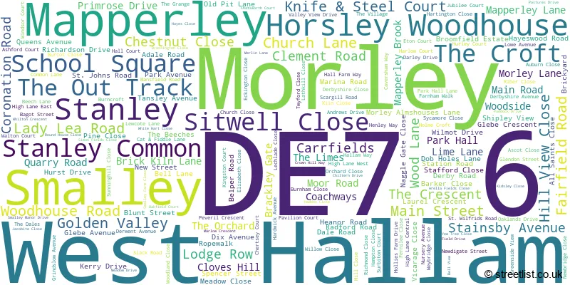
The largest settlement in the DE7 6 postal code is West Hallam followed by Smalley, and Morley.
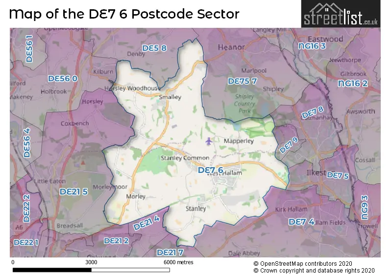
The DE7 6 Postcode shares a border with DE7 4 (ILKESTON, Stanton-by-Dale, Quarry Hill Industrial Estate), DE7 5 (ILKESTON), DE7 8 (ILKESTON, Manners Industrial Estate), DE7 9 (ILKESTON), DE21 2 (Oakwood), DE21 4 (Chaddesden, DERBY, Oakwood), DE21 5 (Little Eaton, Breadsall, Horsley), DE21 7 (Spondon, DERBY), DE56 0 (BELPER, Kilburn, Milford), DE75 7 (HEANOR, Loscoe, Shipley) and DE5 8 (Marehay, Denby, Denby Village).
The sector is within the post town of ILKESTON.
DE7 6 is a postcode sector within the DE7 postcode district which is within the DE Derby postcode area.
The Royal Mail delivery office for the DE7 6 postal sector is the Ilkeston Delivery Office.
The area of the DE7 6 postcode sector is 12.32 square miles which is 31.91 square kilometres or 7,886.10 square acres.

Map of the DE7 6 Postcode Sector
Explore the DE7 6 postcode sector by using our free interactive map.
| D | E | 7 | - | 6 | X | X |
| D | E | 7 | Space | 6 | Letter | Letter |
Official List of Streets
Smalley (42 Streets)
Stanley Common (22 Streets)
West Hallam (67 Streets)
Morley (16 Streets)
Horsley Woodhouse (17 Streets)
Mapperley (11 Streets)
Unofficial Streets or Alternative Spellings
Weather Forecast for DE7 6
Press Button to Show Forecast for Heanor
| Time Period | Icon | Description | Temperature | Rain Probability | Wind |
|---|---|---|---|---|---|
| 15:00 to 18:00 | Cloudy | 19.0°C (feels like 15.0°C) | 4.00% | S 16 mph | |
| 18:00 to 21:00 | Cloudy | 17.0°C (feels like 15.0°C) | 49.00% | SSE 11 mph | |
| 21:00 to 00:00 | Light rain | 15.0°C (feels like 14.0°C) | 52.00% | SSE 11 mph |
Press Button to Show Forecast for Heanor
| Time Period | Icon | Description | Temperature | Rain Probability | Wind |
|---|---|---|---|---|---|
| 00:00 to 03:00 | Heavy rain | 14.0°C (feels like 14.0°C) | 86.00% | ESE 7 mph | |
| 03:00 to 06:00 | Heavy rain | 14.0°C (feels like 12.0°C) | 90.00% | ESE 9 mph | |
| 06:00 to 09:00 | Heavy rain | 14.0°C (feels like 12.0°C) | 93.00% | ESE 9 mph | |
| 09:00 to 12:00 | Heavy rain | 14.0°C (feels like 13.0°C) | 93.00% | SE 9 mph | |
| 12:00 to 15:00 | Heavy rain | 14.0°C (feels like 13.0°C) | 85.00% | SSE 9 mph | |
| 15:00 to 18:00 | Cloudy | 14.0°C (feels like 13.0°C) | 14.00% | SE 9 mph | |
| 18:00 to 21:00 | Cloudy | 15.0°C (feels like 13.0°C) | 12.00% | SE 9 mph | |
| 21:00 to 00:00 | Cloudy | 13.0°C (feels like 12.0°C) | 8.00% | ESE 7 mph |
Press Button to Show Forecast for Heanor
| Time Period | Icon | Description | Temperature | Rain Probability | Wind |
|---|---|---|---|---|---|
| 00:00 to 03:00 | Cloudy | 12.0°C (feels like 11.0°C) | 7.00% | ESE 7 mph | |
| 03:00 to 06:00 | Cloudy | 11.0°C (feels like 10.0°C) | 9.00% | ESE 7 mph | |
| 06:00 to 09:00 | Overcast | 12.0°C (feels like 11.0°C) | 17.00% | E 7 mph | |
| 09:00 to 12:00 | Light rain shower (day) | 14.0°C (feels like 13.0°C) | 37.00% | ESE 7 mph | |
| 12:00 to 15:00 | Cloudy | 16.0°C (feels like 15.0°C) | 18.00% | ESE 7 mph | |
| 15:00 to 18:00 | Light rain shower (day) | 17.0°C (feels like 16.0°C) | 38.00% | ESE 7 mph | |
| 18:00 to 21:00 | Light rain shower (day) | 16.0°C (feels like 15.0°C) | 34.00% | ESE 7 mph | |
| 21:00 to 00:00 | Partly cloudy (night) | 13.0°C (feels like 13.0°C) | 5.00% | E 4 mph |
Press Button to Show Forecast for Heanor
| Time Period | Icon | Description | Temperature | Rain Probability | Wind |
|---|---|---|---|---|---|
| 00:00 to 03:00 | Partly cloudy (night) | 11.0°C (feels like 11.0°C) | 2.00% | ESE 4 mph | |
| 03:00 to 06:00 | Cloudy | 10.0°C (feels like 9.0°C) | 6.00% | ENE 2 mph | |
| 06:00 to 09:00 | Mist | 11.0°C (feels like 10.0°C) | 15.00% | N 4 mph | |
| 09:00 to 12:00 | Sunny day | 15.0°C (feels like 15.0°C) | 6.00% | ENE 4 mph | |
| 12:00 to 15:00 | Cloudy | 18.0°C (feels like 17.0°C) | 11.00% | E 4 mph | |
| 15:00 to 18:00 | Light rain | 18.0°C (feels like 17.0°C) | 43.00% | E 4 mph | |
| 18:00 to 21:00 | Light rain shower (day) | 17.0°C (feels like 16.0°C) | 38.00% | ESE 4 mph | |
| 21:00 to 00:00 | Partly cloudy (night) | 15.0°C (feels like 14.0°C) | 11.00% | E 4 mph |
Press Button to Show Forecast for Heanor
| Time Period | Icon | Description | Temperature | Rain Probability | Wind |
|---|---|---|---|---|---|
| 00:00 to 03:00 | Cloudy | 13.0°C (feels like 12.0°C) | 8.00% | NW 4 mph | |
| 03:00 to 06:00 | Cloudy | 12.0°C (feels like 11.0°C) | 9.00% | NNW 4 mph | |
| 06:00 to 09:00 | Overcast | 12.0°C (feels like 12.0°C) | 12.00% | N 4 mph | |
| 09:00 to 12:00 | Cloudy | 15.0°C (feels like 14.0°C) | 10.00% | N 4 mph | |
| 12:00 to 15:00 | Light rain shower (day) | 18.0°C (feels like 17.0°C) | 32.00% | N 4 mph | |
| 15:00 to 18:00 | Light rain shower (day) | 19.0°C (feels like 18.0°C) | 37.00% | N 7 mph | |
| 18:00 to 21:00 | Light rain shower (day) | 18.0°C (feels like 17.0°C) | 33.00% | N 7 mph | |
| 21:00 to 00:00 | Partly cloudy (night) | 15.0°C (feels like 14.0°C) | 10.00% | NNE 7 mph |
Schools and Places of Education Within the DE7 6 Postcode Sector
Horsley Woodhouse Primary School
Academy converter
Main Street, Ilkeston, Derbyshire, DE7 6AT
Head: Mrs Parmjit Atwal
Ofsted Rating: Good
Inspection: 2023-03-22 (418 days ago)
Website: Visit Horsley Woodhouse Primary School Website
Phone: 01332880403
Number of Pupils: 106
Mapperley CofE Controlled Primary School
Voluntary controlled school
Mapperley Village, Ilkeston, Derbyshire, DE7 6BT
Head: Mr Richard Cripps
Ofsted Rating: Requires improvement
Inspection: 2023-02-08 (460 days ago)
Website: Visit Mapperley CofE Controlled Primary School Website
Phone: 01159325386
Number of Pupils: 65
Morley Primary School
Community school
Main Road, Ilkeston, Derbyshire, DE7 6DF
Head: Mr Anthony Taylor
Ofsted Rating: Outstanding
Inspection: 2012-06-01 (4364 days ago)
Website: Visit Morley Primary School Website
Phone: 01332831295
Number of Pupils: 80
Richardson Endowed Primary School
Academy converter
Main Road, Ilkeston, Derbyshire, DE7 6EF
Head: Mr Martyn Fearn
Ofsted Rating: Good
Inspection: 2023-06-14 (334 days ago)
Website: Visit Richardson Endowed Primary School Website
Phone: 01332880317
Number of Pupils: 199
Scargill CofE Primary School
Academy sponsor led
Beech Lane, Ilkeston, Derbyshire, DE7 6GU
Head: Mrs Sarah Hallsworth
Ofsted Rating: Requires improvement
Inspection: 2022-02-02 (831 days ago)
Website: Visit Scargill CofE Primary School Website
Phone: 01159320005
Number of Pupils: 340
St Andrew's CofE Primary School
Voluntary controlled school
Station Road, Ilkeston, Derbyshire, DE7 6FB
Head: Mrs Elizabeth Stanley-Wainwright
Ofsted Rating: Good
Inspection: 2022-10-12 (579 days ago)
Website: Visit St Andrew's CofE Primary School Website
Phone: 01159324252
Number of Pupils: 94
House Prices in the DE7 6 Postcode Sector
| Type of Property | 2018 Average | 2018 Sales | 2017 Average | 2017 Sales | 2016 Average | 2016 Sales | 2015 Average | 2015 Sales |
|---|---|---|---|---|---|---|---|---|
| Detached | £299,385 | 99 | £287,884 | 134 | £277,551 | 111 | £260,291 | 121 |
| Semi-Detached | £185,046 | 59 | £173,103 | 64 | £165,482 | 67 | £153,891 | 56 |
| Terraced | £141,211 | 29 | £139,371 | 36 | £136,682 | 39 | £141,139 | 46 |
| Flats | £0 | 0 | £0 | 0 | £0 | 0 | £0 | 0 |
Important Postcodes DE7 6 in the Postcode Sector
DE7 6AT is the postcode for Horsley Woodhouse Primary School, Main Street, Horsley Woodhouse
DE7 6AX is the postcode for Arthur Medical Centre, Main Street
DE7 6DF is the postcode for Morley Primary School, Main Road
DE7 6DN is the postcode for LEARNING & SUPPORT BUILDING, Derby College, Broomfield Hall Campus, Broomfield Estate, BROOMFIELD NURSERY, Derby College, Broomfield Hall Campus, Broomfield Estate, MAIN HALL, DINING ROOM AND ANNEXE, Derby College, Broomfield Hall Campus, Broomfield Estate, CHATSWORTH, Derby College, Broomfield Hall Campus, Broomfield Estate, and SPORTS BARN, Derby College, Broomfield Hall Campus, Broomfield Estate
DE7 6EF is the postcode for BLOCK 02, Richardson Endowed Primary School, Main Road, and BLOCK 01, Richardson Endowed Primary School, Main Road
DE7 6FB is the postcode for St. Andrews C of E Voluntary Controlled Primary School, Station Road
DE7 6FS is the postcode for MAIN BUILDING, Stanley Common Church of England Primary School, 143 Belper Road
DE7 6GU is the postcode for Scargill C of E Voluntary Aided Primary School, Beech Lane, West Hallam, Scargill C of E Voluntary Aided Primary School, Beech Lane, and Scargill Church Of England Primary School, Beech Lane
DE7 6JB is the postcode for Beechcroft Old Peoples Home, Nursery Avenue, West Hallam, Beechcroft Old Peoples Home, Nursery Avenue, and MAIN BUILDING, Beechcroft Care Home, Nursery Avenue
| The DE7 6 Sector is within these Local Authorities |
|
|---|---|
| The DE7 6 Sector is within these Counties |
|
| The DE7 6 Sector is within these Water Company Areas |
|