The DE5 9 postcode sector is within the county of Derbyshire.
Did you know? According to the 2021 Census, the DE5 9 postcode sector is home to a bustling 5,006 residents!
Given that each sector allows for 400 unique postcode combinations. Letters C, I, K, M, O and V are not allowed in the last two letters of a postcode. With 87 postcodes already in use, this leaves 313 units available.
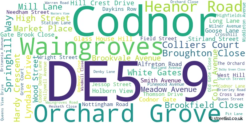
The largest settlements in the DE5 9 postal code are Codnor and Waingroves.
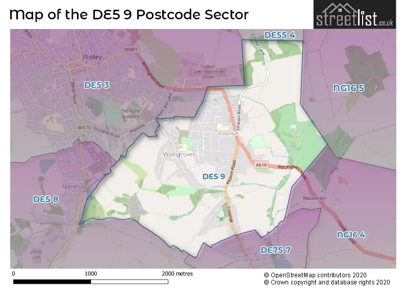
The DE5 9 Postcode shares a border with DE5 3 (RIPLEY, Pentrich, Butterley), DE55 4 (Somercotes, Riddings, Pye Bridge), DE75 7 (HEANOR, Loscoe, Shipley), NG16 4 (Langley Mill), NG16 5 (Brinsley, Underwood, Jacksdale) and DE5 8 (Marehay, Denby, Denby Village).
The sector is within the post town of RIPLEY.
DE5 9 is a postcode sector within the DE5 postcode district which is within the DE Derby postcode area.
The Royal Mail delivery office for the DE5 9 postal sector is the Ripley (de) Delivery Office.
The area of the DE5 9 postcode sector is 1.81 square miles which is 4.68 square kilometres or 1,157.33 square acres.

Map of the DE5 9 Postcode Sector
Explore the DE5 9 postcode sector by using our free interactive map.
| D | E | 5 | - | 9 | X | X |
| D | E | 5 | Space | 9 | Letter | Letter |
Official List of Streets
Codnor (50 Streets)
Waingroves (14 Streets)
Unofficial Streets or Alternative Spellings
RIPLEY
COUPE STREET HIGH HOLBORN ROAD NOTTINGHAM ROAD STEAM MILL LANE WHITELEY ROADWeather Forecast for DE5 9
Press Button to Show Forecast for Ripley
| Time Period | Icon | Description | Temperature | Rain Probability | Wind |
|---|---|---|---|---|---|
| 21:00 to 00:00 | Cloudy | 17.0°C (feels like 16.0°C) | 3.00% | ESE 7 mph |
Press Button to Show Forecast for Ripley
| Time Period | Icon | Description | Temperature | Rain Probability | Wind |
|---|---|---|---|---|---|
| 00:00 to 03:00 | Cloudy | 14.0°C (feels like 14.0°C) | 3.00% | SE 4 mph | |
| 03:00 to 06:00 | Cloudy | 13.0°C (feels like 12.0°C) | 3.00% | ESE 4 mph | |
| 06:00 to 09:00 | Cloudy | 13.0°C (feels like 12.0°C) | 3.00% | ESE 4 mph | |
| 09:00 to 12:00 | Cloudy | 16.0°C (feels like 15.0°C) | 4.00% | ESE 7 mph | |
| 12:00 to 15:00 | Cloudy | 20.0°C (feels like 18.0°C) | 4.00% | SE 9 mph | |
| 15:00 to 18:00 | Cloudy | 21.0°C (feels like 19.0°C) | 4.00% | SE 9 mph | |
| 18:00 to 21:00 | Cloudy | 20.0°C (feels like 18.0°C) | 4.00% | ESE 9 mph | |
| 21:00 to 00:00 | Cloudy | 16.0°C (feels like 15.0°C) | 4.00% | ESE 9 mph |
Press Button to Show Forecast for Ripley
| Time Period | Icon | Description | Temperature | Rain Probability | Wind |
|---|---|---|---|---|---|
| 00:00 to 03:00 | Cloudy | 13.0°C (feels like 12.0°C) | 3.00% | E 7 mph | |
| 03:00 to 06:00 | Cloudy | 11.0°C (feels like 10.0°C) | 3.00% | ENE 7 mph | |
| 06:00 to 09:00 | Cloudy | 12.0°C (feels like 11.0°C) | 3.00% | ENE 7 mph | |
| 09:00 to 12:00 | Cloudy | 16.0°C (feels like 15.0°C) | 3.00% | E 7 mph | |
| 12:00 to 15:00 | Cloudy | 20.0°C (feels like 19.0°C) | 6.00% | ESE 9 mph | |
| 15:00 to 18:00 | Cloudy | 21.0°C (feels like 19.0°C) | 13.00% | SE 11 mph | |
| 18:00 to 21:00 | Light rain shower (day) | 18.0°C (feels like 17.0°C) | 39.00% | S 7 mph | |
| 21:00 to 00:00 | Cloudy | 16.0°C (feels like 15.0°C) | 18.00% | S 7 mph |
Press Button to Show Forecast for Ripley
| Time Period | Icon | Description | Temperature | Rain Probability | Wind |
|---|---|---|---|---|---|
| 00:00 to 03:00 | Cloudy | 14.0°C (feels like 13.0°C) | 13.00% | SSE 7 mph | |
| 03:00 to 06:00 | Cloudy | 13.0°C (feels like 12.0°C) | 13.00% | S 7 mph | |
| 06:00 to 09:00 | Cloudy | 13.0°C (feels like 11.0°C) | 12.00% | S 9 mph | |
| 09:00 to 12:00 | Cloudy | 14.0°C (feels like 13.0°C) | 15.00% | S 9 mph | |
| 12:00 to 15:00 | Cloudy | 16.0°C (feels like 14.0°C) | 20.00% | SSE 11 mph | |
| 15:00 to 18:00 | Light rain | 16.0°C (feels like 14.0°C) | 56.00% | SSE 13 mph | |
| 18:00 to 21:00 | Light rain | 14.0°C (feels like 13.0°C) | 59.00% | SSE 11 mph | |
| 21:00 to 00:00 | Heavy rain shower (night) | 13.0°C (feels like 11.0°C) | 62.00% | SSE 11 mph |
Press Button to Show Forecast for Ripley
| Time Period | Icon | Description | Temperature | Rain Probability | Wind |
|---|---|---|---|---|---|
| 00:00 to 03:00 | Light rain | 12.0°C (feels like 10.0°C) | 50.00% | SSE 9 mph | |
| 03:00 to 06:00 | Cloudy | 11.0°C (feels like 10.0°C) | 18.00% | SE 9 mph | |
| 06:00 to 09:00 | Cloudy | 11.0°C (feels like 10.0°C) | 15.00% | SSE 9 mph | |
| 09:00 to 12:00 | Light rain shower (day) | 13.0°C (feels like 11.0°C) | 33.00% | SSE 11 mph | |
| 12:00 to 15:00 | Light rain shower (day) | 15.0°C (feels like 13.0°C) | 33.00% | SSE 13 mph | |
| 15:00 to 18:00 | Light rain shower (day) | 15.0°C (feels like 13.0°C) | 39.00% | SSE 11 mph | |
| 18:00 to 21:00 | Light rain shower (day) | 14.0°C (feels like 12.0°C) | 37.00% | SSE 11 mph | |
| 21:00 to 00:00 | Partly cloudy (night) | 12.0°C (feels like 10.0°C) | 12.00% | SE 9 mph |
Schools and Places of Education Within the DE5 9 Postcode Sector
Codnor Community Primary School Church of England Controlled
Voluntary controlled school
Whitegates, Ripley, Derbyshire, DE5 9QD
Head: Mr James Blake
Ofsted Rating: Good
Inspection: 2021-11-24 (898 days ago)
Website: Visit Codnor Community Primary School Church of England Controlled Website
Phone: 01773742537
Number of Pupils: 251
Waingroves Primary School
Academy converter
Waingroves Road, Ripley, Derbyshire, DE5 9TD
Head: Mrs Amarjeet Challand
Ofsted Rating: Good
Inspection: 2023-07-13 (302 days ago)
Website: Visit Waingroves Primary School Website
Phone: 01773744106
Number of Pupils: 206
House Prices in the DE5 9 Postcode Sector
| Type of Property | 2018 Average | 2018 Sales | 2017 Average | 2017 Sales | 2016 Average | 2016 Sales | 2015 Average | 2015 Sales |
|---|---|---|---|---|---|---|---|---|
| Detached | £242,170 | 39 | £219,944 | 28 | £208,428 | 40 | £196,813 | 31 |
| Semi-Detached | £143,843 | 36 | £152,295 | 47 | £144,335 | 33 | £126,285 | 24 |
| Terraced | £99,245 | 22 | £86,693 | 20 | £90,218 | 31 | £78,793 | 23 |
| Flats | £75,000 | 1 | £0 | 0 | £0 | 0 | £0 | 0 |
Important Postcodes DE5 9 in the Postcode Sector
DE5 9QD is the postcode for Codnor Community Primary School, White Gates, and Main Building, Codnor Community Primary School, White Gates
DE5 9QF is the postcode for Adult Community Education Centre, Peverel House, Mill Lane
DE5 9TD is the postcode for MAIN BLOCK, Waingroves Primary School, Waingroves Road
| The DE5 9 Sector is within these Local Authorities |
|
|---|---|
| The DE5 9 Sector is within these Counties |
|
| The DE5 9 Sector is within these Water Company Areas |
|