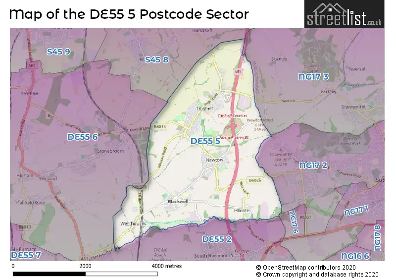
The DE55 5 postcode sector stands on the Derbyshire and Nottinghamshire border.
Did you know? According to the 2021 Census, the DE55 5 postcode sector is home to a bustling 8,579 residents!
Given that each sector allows for 400 unique postcode combinations. Letters C, I, K, M, O and V are not allowed in the last two letters of a postcode. With 191 postcodes already in use, this leaves 209 units available.
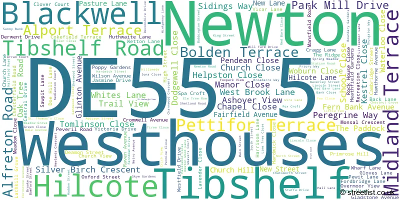
The largest settlement in the DE55 5 postal code is Tibshelf followed by Newton, and Blackwell.
The DE55 5 Postcode shares a border with S45 8 (Pilsley, Lower Pilsley), DE55 2 (South Normanton), DE55 6 (Shirland, Stonebroom, Morton), DE55 7 (ALFRETON, South Wingfield, Oakerthorpe), NG17 2 (SUTTON-IN-ASHFIELD, Huthwaite) and NG17 3 (SUTTON-IN-ASHFIELD, Stanton Hill, Skegby).
The sector is within the post town of ALFRETON.
DE55 5 is a postcode sector within the DE5 postcode district which is within the DE Derby postcode area.
The Royal Mail delivery office for the DE55 5 postal sector is the unknown.
The area of the DE55 5 postcode sector is 5.71 square miles which is 14.78 square kilometres or 3,652.23 square acres.
The DE55 5 postcode sector is crossed by the M1 motorway.
Waterways within the DE55 5 postcode sector include the Westwood Brook, Blackwell Brook, Alfreton Brook, Normanton Brook.

Map of the DE55 5 Postcode Sector
Explore the DE55 5 postcode sector by using our free interactive map.
| D | E | 5 | 5 | - | 5 | X | X |
| D | E | 5 | 5 | Space | 5 | Letter | Letter |
Official List of Streets
Tibshelf (72 Streets)
Blackwell (28 Streets)
Newton (36 Streets)
Westhouses (11 Streets)
Unofficial Streets or Alternative Spellings
SUTTON-IN-ASHFIELD
WILD HILLSouth Normanton
BERRISTOW LANE BIGGIN LANE BLACKWELL TRAIL COLLIERY ROAD FIVE PITS TRAIL FIVE PITS TRAIL NEWTON LINK LATHKIL GROVE NEW ROAD SAW PIT INDUSTRIAL ESTATE SILVERHILL TRAIL ST KILDA PLACE STEPS SUNNYBANK THE GREEN TIBSHELF CANTER TRACK TOWN LANEShirland
PARK LANEPilsley
CHESTERFIELD ROADMorton
PEWIT LANEStonebroom
DOE HILL LANEWeather Forecast for DE55 5
Press Button to Show Forecast for Hardwick Hall Garden (Nt)
| Time Period | Icon | Description | Temperature | Rain Probability | Wind |
|---|---|---|---|---|---|
| 18:00 to 21:00 | Sunny day | 9.0°C (feels like 7.0°C) | 0.00% | W 9 mph | |
| 21:00 to 00:00 | Clear night | 6.0°C (feels like 3.0°C) | 0.00% | SSW 9 mph |
Press Button to Show Forecast for Hardwick Hall Garden (Nt)
| Time Period | Icon | Description | Temperature | Rain Probability | Wind |
|---|---|---|---|---|---|
| 00:00 to 03:00 | Clear night | 5.0°C (feels like 1.0°C) | 5.00% | SSW 11 mph | |
| 03:00 to 06:00 | Light rain | 6.0°C (feels like 2.0°C) | 45.00% | SSW 13 mph | |
| 06:00 to 09:00 | Cloudy | 7.0°C (feels like 3.0°C) | 6.00% | SSW 13 mph | |
| 09:00 to 12:00 | Cloudy | 11.0°C (feels like 7.0°C) | 5.00% | SSW 18 mph | |
| 12:00 to 15:00 | Cloudy | 12.0°C (feels like 9.0°C) | 16.00% | S 20 mph | |
| 15:00 to 18:00 | Cloudy | 13.0°C (feels like 9.0°C) | 51.00% | SSW 18 mph | |
| 18:00 to 21:00 | Overcast | 11.0°C (feels like 8.0°C) | 16.00% | S 16 mph | |
| 21:00 to 00:00 | Cloudy | 11.0°C (feels like 8.0°C) | 12.00% | S 16 mph |
Press Button to Show Forecast for Hardwick Hall Garden (Nt)
| Time Period | Icon | Description | Temperature | Rain Probability | Wind |
|---|---|---|---|---|---|
| 00:00 to 03:00 | Cloudy | 9.0°C (feels like 6.0°C) | 4.00% | S 13 mph | |
| 03:00 to 06:00 | Clear night | 8.0°C (feels like 5.0°C) | 1.00% | SSE 13 mph | |
| 06:00 to 09:00 | Partly cloudy (day) | 8.0°C (feels like 5.0°C) | 1.00% | SSE 11 mph | |
| 09:00 to 12:00 | Sunny day | 13.0°C (feels like 10.0°C) | 1.00% | SSE 13 mph | |
| 12:00 to 15:00 | Sunny day | 16.0°C (feels like 13.0°C) | 3.00% | SSE 16 mph | |
| 15:00 to 18:00 | Cloudy | 17.0°C (feels like 13.0°C) | 6.00% | SSE 13 mph | |
| 18:00 to 21:00 | Partly cloudy (day) | 15.0°C (feels like 13.0°C) | 4.00% | SSE 9 mph | |
| 21:00 to 00:00 | Partly cloudy (night) | 11.0°C (feels like 10.0°C) | 5.00% | SSE 7 mph |
Press Button to Show Forecast for Hardwick Hall Garden (Nt)
| Time Period | Icon | Description | Temperature | Rain Probability | Wind |
|---|---|---|---|---|---|
| 00:00 to 03:00 | Cloudy | 9.0°C (feels like 8.0°C) | 9.00% | SSE 4 mph | |
| 03:00 to 06:00 | Cloudy | 9.0°C (feels like 8.0°C) | 8.00% | SSE 4 mph | |
| 06:00 to 09:00 | Cloudy | 9.0°C (feels like 8.0°C) | 11.00% | SE 4 mph | |
| 09:00 to 12:00 | Overcast | 12.0°C (feels like 11.0°C) | 12.00% | SE 4 mph | |
| 12:00 to 15:00 | Cloudy | 15.0°C (feels like 14.0°C) | 10.00% | ESE 7 mph | |
| 15:00 to 18:00 | Cloudy | 15.0°C (feels like 15.0°C) | 11.00% | E 4 mph | |
| 18:00 to 21:00 | Cloudy | 14.0°C (feels like 13.0°C) | 11.00% | NNE 7 mph | |
| 21:00 to 00:00 | Cloudy | 12.0°C (feels like 11.0°C) | 12.00% | NNE 7 mph |
Press Button to Show Forecast for Hardwick Hall Garden (Nt)
| Time Period | Icon | Description | Temperature | Rain Probability | Wind |
|---|---|---|---|---|---|
| 00:00 to 03:00 | Overcast | 10.0°C (feels like 9.0°C) | 16.00% | N 9 mph | |
| 03:00 to 06:00 | Light rain | 10.0°C (feels like 8.0°C) | 41.00% | NNW 9 mph | |
| 06:00 to 09:00 | Light rain | 10.0°C (feels like 8.0°C) | 40.00% | NNW 9 mph | |
| 09:00 to 12:00 | Cloudy | 12.0°C (feels like 11.0°C) | 11.00% | NNW 11 mph | |
| 12:00 to 15:00 | Cloudy | 16.0°C (feels like 14.0°C) | 6.00% | NNW 11 mph | |
| 15:00 to 18:00 | Cloudy | 17.0°C (feels like 14.0°C) | 5.00% | NNW 11 mph | |
| 18:00 to 21:00 | Partly cloudy (day) | 15.0°C (feels like 13.0°C) | 3.00% | NNW 11 mph | |
| 21:00 to 00:00 | Partly cloudy (night) | 11.0°C (feels like 10.0°C) | 1.00% | NNW 9 mph |
Schools and Places of Education Within the DE55 5 Postcode Sector
Blackwell Community Primary and Nursery School
Community school
Primrose Hill, Alfreton, Derbyshire, DE55 5JG
Head: Mrs Gill Gardner
Ofsted Rating: Good
Inspection: 2021-07-15 (1018 days ago)
Website: Visit Blackwell Community Primary and Nursery School Website
Phone: 01773811281
Number of Pupils: 121
Newton Primary School
Community school
Hall Lane, Alfreton, Derbyshire, DE55 5TL
Head: Mrs Kim Stow
Ofsted Rating: Good
Inspection: 2023-03-07 (418 days ago)
Website: Visit Newton Primary School Website
Phone: 01773872384
Number of Pupils: 139
Tibshelf Community School
Community school
Doe Hill Lane, Alfreton, Derbyshire, DE55 5LZ
Head: Mrs Lucie Wainwright
Ofsted Rating: Good
Inspection: 2021-09-30 (941 days ago)
Website: Visit Tibshelf Community School Website
Phone: 01773872391
Number of Pupils: 809
Tibshelf Infant School
Community school
144 High Street, Alfreton, Derbyshire, DE55 5PP
Head: Mrs Rachel Boswell
Ofsted Rating: Good
Inspection: 2022-11-16 (529 days ago)
Website: Visit Tibshelf Infant School Website
Phone: 01773872571
Number of Pupils: 186
Town End Junior School
Community school
Alfreton Road, Alfreton, Derbyshire, DE55 5PB
Head: Mrs Rachel Boswell
Ofsted Rating: Good
Inspection: 2023-10-25 (186 days ago)
Website: Visit Town End Junior School Website
Phone: 01773872306
Number of Pupils: 173
Westhouses Primary School
Community school
Bolden Terrace, Alfreton, Derbyshire, DE55 5AF
Head: Mrs Juliette Whitby
Ofsted Rating: Good
Inspection: 2022-09-22 (584 days ago)
Website: Visit Westhouses Primary School Website
Phone: 01773832518
Number of Pupils: 67
House Prices in the DE55 5 Postcode Sector
| Type of Property | 2018 Average | 2018 Sales | 2017 Average | 2017 Sales | 2016 Average | 2016 Sales | 2015 Average | 2015 Sales |
|---|---|---|---|---|---|---|---|---|
| Detached | £217,656 | 80 | £196,721 | 74 | £181,674 | 69 | £181,474 | 53 |
| Semi-Detached | £133,779 | 70 | £129,941 | 77 | £105,232 | 57 | £106,632 | 49 |
| Terraced | £101,636 | 25 | £87,207 | 37 | £86,277 | 39 | £95,876 | 29 |
| Flats | £0 | 0 | £72,000 | 1 | £0 | 0 | £0 | 0 |
Important Postcodes DE55 5 in the Postcode Sector
DE55 5AF is the postcode for Westhouses Primary School, Bolden Terrace
DE55 5JG is the postcode for Blackwell Primary School, Primrose Hill
DE55 5LZ is the postcode for TEACHING BLOCK 3, Tibshelf Community School, Doe Hill Lane, TIBSHELF COMMUNITY SCHOOL, DOE HILL LANE, TEACHING BLOCK 1, Tibshelf Community School, Doe Hill Lane, and MAIN BLOCK, Tibshelf Community School, Doe Hill Lane
DE55 5PB is the postcode for Town End Junior School, Alfreton Road
DE55 5PP is the postcode for Tibshelf Community School & Specialist Sports College, High Street, and Tibshelf Infant & Nursery School, High Street
DE55 5PS is the postcode for Main Building, Holmlea Home for Older People, Waverley Street, Main Building, Holmlea Care Home, Waverley Street, Staffa Health Centre, 3 Waverley Street, and Holmlea Home for Older People, Waverley Street
DE55 5TL is the postcode for Newton Primary School, Hall Lane
| The DE55 5 Sector is within these Local Authorities |
|
|---|---|
| The DE55 5 Sector is within these Counties |
|
| The DE55 5 Sector is within these Water Company Areas |
|