The DN22 6 postcode sector is within the county of Nottinghamshire.
Did you know? According to the 2021 Census, the DN22 6 postcode sector is home to a bustling 6,956 residents!
Given that each sector allows for 400 unique postcode combinations. Letters C, I, K, M, O and V are not allowed in the last two letters of a postcode. With 227 postcodes already in use, this leaves 173 units available.
The DN22 6 postal code covers the settlement of RETFORD.
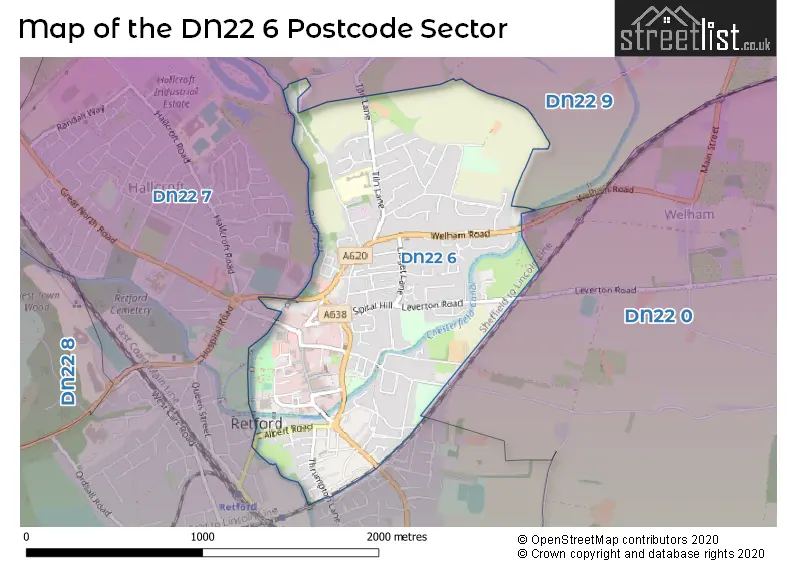
The DN22 6 Postcode shares a border with DN22 0 (North Leverton, Rampton, South Leverton), DN22 7 (RETFORD) and DN22 9 (Clarborough, North Wheatley, Sturton-le-Steeple).
The sector is within the post town of RETFORD.
DN22 6 is a postcode sector within the DN22 postcode district which is within the DN Doncaster postcode area.
The Royal Mail delivery office for the DN22 6 postal sector is the Retford Delivery Office.
The area of the DN22 6 postcode sector is 1.00 square miles which is 2.58 square kilometres or 637.12 square acres.
Waterways within the DN22 6 postcode sector include the Chesterfield Canal, River Idle.

Map of the DN22 6 Postcode Sector
Explore the DN22 6 postcode sector by using our free interactive map.
| D | N | 2 | 2 | - | 6 | X | X |
| D | N | 2 | 2 | Space | 6 | Letter | Letter |
Official List of Streets
RETFORD (136 Streets)
Unofficial Streets or Alternative Spellings
Weather Forecast for DN22 6
Press Button to Show Forecast for Retford
| Time Period | Icon | Description | Temperature | Rain Probability | Wind |
|---|---|---|---|---|---|
| 18:00 to 21:00 | Cloudy | 21.0°C (feels like 19.0°C) | 4.00% | ESE 9 mph | |
| 21:00 to 00:00 | Clear night | 16.0°C (feels like 15.0°C) | 0.00% | SE 7 mph |
Press Button to Show Forecast for Retford
| Time Period | Icon | Description | Temperature | Rain Probability | Wind |
|---|---|---|---|---|---|
| 00:00 to 03:00 | Cloudy | 15.0°C (feels like 14.0°C) | 3.00% | SSE 7 mph | |
| 03:00 to 06:00 | Cloudy | 12.0°C (feels like 12.0°C) | 3.00% | SE 4 mph | |
| 06:00 to 09:00 | Partly cloudy (day) | 12.0°C (feels like 12.0°C) | 0.00% | SE 7 mph | |
| 09:00 to 12:00 | Cloudy | 17.0°C (feels like 16.0°C) | 3.00% | SE 7 mph | |
| 12:00 to 15:00 | Cloudy | 21.0°C (feels like 19.0°C) | 3.00% | SE 9 mph | |
| 15:00 to 18:00 | Cloudy | 22.0°C (feels like 20.0°C) | 4.00% | SE 9 mph | |
| 18:00 to 21:00 | Cloudy | 20.0°C (feels like 18.0°C) | 3.00% | ESE 11 mph | |
| 21:00 to 00:00 | Cloudy | 15.0°C (feels like 14.0°C) | 4.00% | ESE 9 mph |
Press Button to Show Forecast for Retford
| Time Period | Icon | Description | Temperature | Rain Probability | Wind |
|---|---|---|---|---|---|
| 00:00 to 03:00 | Cloudy | 12.0°C (feels like 12.0°C) | 3.00% | ESE 7 mph | |
| 03:00 to 06:00 | Cloudy | 11.0°C (feels like 10.0°C) | 4.00% | E 4 mph | |
| 06:00 to 09:00 | Cloudy | 12.0°C (feels like 12.0°C) | 4.00% | ENE 4 mph | |
| 09:00 to 12:00 | Cloudy | 17.0°C (feels like 17.0°C) | 4.00% | ESE 7 mph | |
| 12:00 to 15:00 | Cloudy | 21.0°C (feels like 20.0°C) | 7.00% | SE 9 mph | |
| 15:00 to 18:00 | Cloudy | 22.0°C (feels like 19.0°C) | 14.00% | SE 11 mph | |
| 18:00 to 21:00 | Cloudy | 20.0°C (feels like 18.0°C) | 10.00% | SE 9 mph | |
| 21:00 to 00:00 | Cloudy | 16.0°C (feels like 16.0°C) | 13.00% | SSE 7 mph |
Press Button to Show Forecast for Retford
| Time Period | Icon | Description | Temperature | Rain Probability | Wind |
|---|---|---|---|---|---|
| 00:00 to 03:00 | Cloudy | 15.0°C (feels like 14.0°C) | 13.00% | SSE 4 mph | |
| 03:00 to 06:00 | Cloudy | 14.0°C (feels like 13.0°C) | 15.00% | SE 7 mph | |
| 06:00 to 09:00 | Cloudy | 14.0°C (feels like 13.0°C) | 15.00% | SW 9 mph | |
| 09:00 to 12:00 | Cloudy | 16.0°C (feels like 15.0°C) | 14.00% | S 11 mph | |
| 12:00 to 15:00 | Cloudy | 18.0°C (feels like 16.0°C) | 17.00% | S 11 mph | |
| 15:00 to 18:00 | Cloudy | 18.0°C (feels like 16.0°C) | 24.00% | SSE 13 mph | |
| 18:00 to 21:00 | Heavy rain | 16.0°C (feels like 14.0°C) | 76.00% | SSE 11 mph | |
| 21:00 to 00:00 | Light rain | 14.0°C (feels like 13.0°C) | 52.00% | SE 11 mph |
Press Button to Show Forecast for Retford
| Time Period | Icon | Description | Temperature | Rain Probability | Wind |
|---|---|---|---|---|---|
| 00:00 to 03:00 | Light rain | 13.0°C (feels like 11.0°C) | 48.00% | SSE 9 mph | |
| 03:00 to 06:00 | Light rain | 12.0°C (feels like 11.0°C) | 46.00% | SE 9 mph | |
| 06:00 to 09:00 | Cloudy | 13.0°C (feels like 11.0°C) | 12.00% | SSE 9 mph | |
| 09:00 to 12:00 | Light rain | 14.0°C (feels like 13.0°C) | 43.00% | SSE 11 mph | |
| 12:00 to 15:00 | Light rain shower (day) | 16.0°C (feels like 14.0°C) | 32.00% | SSE 13 mph | |
| 15:00 to 18:00 | Light rain shower (day) | 17.0°C (feels like 14.0°C) | 35.00% | SSE 13 mph | |
| 18:00 to 21:00 | Light rain shower (day) | 15.0°C (feels like 13.0°C) | 32.00% | SSE 11 mph | |
| 21:00 to 00:00 | Clear night | 13.0°C (feels like 11.0°C) | 5.00% | SSE 9 mph |
Schools and Places of Education Within the DN22 6 Postcode Sector
Carr Hill Primary and Nursery School
Community school
Tiln Lane, Retford, Nottinghamshire, DN22 6SW
Head: Mrs Sally I Alford
Ofsted Rating: Good
Inspection: 2022-04-27 (744 days ago)
Website: Visit Carr Hill Primary and Nursery School Website
Phone: 01777702948
Number of Pupils: 356
St Swithun's Church of England Primary Academy
Academy converter
Grove Street, Retford, Nottinghamshire, DN22 6LD
Head: Mr Paul Charly
Ofsted Rating: Requires improvement
Inspection: 2022-09-14 (604 days ago)
Website: Visit St Swithun's Church of England Primary Academy Website
Phone: 01777702043
Number of Pupils: 117
House Prices in the DN22 6 Postcode Sector
| Type of Property | 2018 Average | 2018 Sales | 2017 Average | 2017 Sales | 2016 Average | 2016 Sales | 2015 Average | 2015 Sales |
|---|---|---|---|---|---|---|---|---|
| Detached | £220,688 | 32 | £234,093 | 37 | £210,578 | 56 | £195,081 | 26 |
| Semi-Detached | £133,639 | 31 | £129,536 | 35 | £125,734 | 54 | £128,662 | 51 |
| Terraced | £107,897 | 58 | £127,757 | 41 | £107,133 | 47 | £119,212 | 52 |
| Flats | £106,635 | 17 | £110,918 | 14 | £77,154 | 13 | £76,388 | 9 |
Important Postcodes DN22 6 in the Postcode Sector
DN22 6AA is the postcode for Riverside Health Partnership, Riverside Walk
DN22 6AB is the postcode for H M Revenue & Customs, Kings Park House, Bridgegate, Bridgegate Centre
DN22 6BT is the postcode for The Old Police Station, Exchange Street
DN22 6DB is the postcode for RETFORD TOWN HALL, 17, The Square
DN22 6DE is the postcode for RETFORD TOWN HALL, Bassetlaw District Council, 17 The Square
DN22 6DG is the postcode for Nottinghamshire County Council, Chancery Lane
DN22 6JR is the postcode for Jobcentre Plus, 23a Grove Street
DN22 6JX is the postcode for Retford Bus Station, Beardsalls Row
DN22 6LD is the postcode for St. Swithuns C of E Primary School, 56 Grove Street
DN22 6QD is the postcode for Nottinghamshire Police, Retford Police Station
DN22 6SW is the postcode for Carr Hill Primary School, Tiln Lane
| The DN22 6 Sector is within these Local Authorities |
|
|---|---|
| The DN22 6 Sector is within these Counties |
|
| The DN22 6 Sector is within these Water Company Areas |
|
Tourist Attractions within the DN22 6 Postcode Area
We found 1 visitor attractions within the DN22 postcode area
| Bassetlaw Museum |
|---|
| Museums & Art Galleries |
| Museum and / or Art Gallery |
| View Bassetlaw Museum on Google Maps |