The DT10 postcode district is a postal district located in the DT Dorchester postcode area with a population of 12,047 residents according to the 2021 England and Wales Census.
The area of the DT10 postcode district is 44.92 square miles which is 116.34 square kilometres or 28,748.85 acres.
Currently, the DT10 district has about 451 postcode units spread across 2 geographic postcode sectors.
Given that each sector allows for 400 unique postcode combinations, the district has a capacity of 800 postcodes. With 451 postcodes already in use, this leaves 349 units available.
The largest settlement in the DT10 postal code is STURMINSTER NEWTON followed by Stalbridge, and Marnhull.
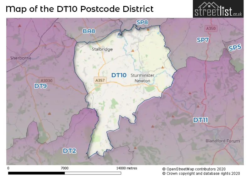
The DT10 Postcode shares a border with BA8 (Henstridge, TEMPLECOMBE, Horsington), DT11 (BLANDFORD FORUM, Blandford St. Mary, Milborne St. Andrew), SP7 (SHAFTESBURY, Motcombe, Donhead St. Mary), SP8 (GILLINGHAM, Bourton, East Stour) and DT2 (Crossways, Charminster, Puddletown).
The primary settlement in the DT10 postcode district is Sturminster Newton, which is located in the county of Dorset, England. Other significant settlements in this district include Hinton St. Mary, Manston, Marnhull, Moorside, Rixon, and Todber. The most significant post town in this district is Sturminster Newton.
For the district DT10, we have data on 3 postcode sectors. Here's a breakdown: The sector DT10 1, covers Sturminster Newton and Marnhull in Dorset. The sector DT10 2, covers Stalbridge in Dorset. The sector DT10 9 is non-geographic. It's often designated for PO Boxes, large organisations, or special services.

Map of the DT10 Postcode District
Explore the DT10 postcode district by using our free interactive map.
When it comes to local government, postal geography often disregards political borders. However, for a breakdown in the DT10 District: the district mostly encompasses the Dorset area with a total of 463 postcodes.
Recent House Sales in DT10
| Date | Price | Address |
|---|---|---|
| 18/10/2023 | £700,000 | Pleck, Hazelbury Bryan, Sturminster Newton, DT10 2EF |
| 16/10/2023 | £302,500 | Vale Road, Stalbridge, Sturminster Newton, DT10 2NS |
| 06/10/2023 | £617,500 | Churchfoot Lane, Hazelbury Bryan, Sturminster Newton, DT10 2DS |
| 29/09/2023 | £465,000 | White Lane Close, Sturminster Newton, DT10 1EJ |
| 19/09/2023 | £412,500 | Maple Row, Stalbridge, Sturminster Newton, DT10 2NR |
| 15/09/2023 | £270,000 | Vale Road, Stalbridge, Sturminster Newton, DT10 2NS |
| 08/09/2023 | £325,000 | Thomas Hardy Close, Sturminster Newton, DT10 1PG |
| 07/09/2023 | £360,000 | Rixon, Sturminster Newton, DT10 1BQ |
| 31/08/2023 | £640,000 | Bakers Field, Stalbridge, Sturminster Newton, DT10 2FB |
| 30/08/2023 | £415,000 | Larks Meadow, Stalbridge, Sturminster Newton, DT10 2LF |
Weather Forecast for DT10
Press Button to Show Forecast for Sturminster Newton
| Time Period | Icon | Description | Temperature | Rain Probability | Wind |
|---|---|---|---|---|---|
| 06:00 to 09:00 | Cloudy | 6.0°C (feels like 4.0°C) | 9.00% | E 7 mph | |
| 09:00 to 12:00 | Cloudy | 8.0°C (feels like 6.0°C) | 11.00% | E 9 mph | |
| 12:00 to 15:00 | Overcast | 9.0°C (feels like 7.0°C) | 19.00% | E 9 mph | |
| 15:00 to 18:00 | Overcast | 9.0°C (feels like 7.0°C) | 22.00% | E 9 mph | |
| 18:00 to 21:00 | Cloudy | 9.0°C (feels like 7.0°C) | 17.00% | E 9 mph | |
| 21:00 to 00:00 | Overcast | 7.0°C (feels like 5.0°C) | 18.00% | E 7 mph |
Press Button to Show Forecast for Sturminster Newton
| Time Period | Icon | Description | Temperature | Rain Probability | Wind |
|---|---|---|---|---|---|
| 00:00 to 03:00 | Cloudy | 6.0°C (feels like 4.0°C) | 21.00% | ENE 7 mph | |
| 03:00 to 06:00 | Light rain | 6.0°C (feels like 3.0°C) | 54.00% | ENE 9 mph | |
| 06:00 to 09:00 | Light rain | 6.0°C (feels like 3.0°C) | 50.00% | ENE 9 mph | |
| 09:00 to 12:00 | Cloudy | 8.0°C (feels like 6.0°C) | 17.00% | ENE 11 mph | |
| 12:00 to 15:00 | Cloudy | 11.0°C (feels like 9.0°C) | 16.00% | E 11 mph | |
| 15:00 to 18:00 | Light rain | 11.0°C (feels like 9.0°C) | 50.00% | ENE 11 mph | |
| 18:00 to 21:00 | Light rain | 10.0°C (feels like 8.0°C) | 53.00% | ENE 11 mph | |
| 21:00 to 00:00 | Light rain | 9.0°C (feels like 6.0°C) | 50.00% | ENE 11 mph |
Press Button to Show Forecast for Sturminster Newton
| Time Period | Icon | Description | Temperature | Rain Probability | Wind |
|---|---|---|---|---|---|
| 00:00 to 03:00 | Light rain | 8.0°C (feels like 6.0°C) | 53.00% | NE 11 mph | |
| 03:00 to 06:00 | Light rain | 8.0°C (feels like 5.0°C) | 54.00% | NE 9 mph | |
| 06:00 to 09:00 | Heavy rain | 8.0°C (feels like 5.0°C) | 73.00% | NE 9 mph | |
| 09:00 to 12:00 | Light rain shower (day) | 10.0°C (feels like 8.0°C) | 40.00% | E 11 mph | |
| 12:00 to 15:00 | Heavy rain shower (day) | 11.0°C (feels like 9.0°C) | 56.00% | NNE 11 mph | |
| 15:00 to 18:00 | Light rain shower (day) | 12.0°C (feels like 9.0°C) | 40.00% | S 11 mph | |
| 18:00 to 21:00 | Light rain shower (day) | 11.0°C (feels like 9.0°C) | 34.00% | S 9 mph | |
| 21:00 to 00:00 | Clear night | 8.0°C (feels like 6.0°C) | 4.00% | W 7 mph |
Where is the DT10 Postcode District?
The postcode district for DT10 is located in Sturminster Newton. It is surrounded by nearby towns such as Templecombe to the northwest (6.03 miles away), Shaftesbury to the northeast (7.72 miles away), Blandford Forum to the southeast (8.36 miles away), Sherborne to the west (8.43 miles away), and Gillingham to the north (8.5 miles away). Additionally, the distance from this postcode district to the center of London is approximately 104.08 miles.
The district is within the post town of STURMINSTER NEWTON.
The sector has postcodes within the nation of England.
The DT10 Postcode District is in the Somerset region of Dorset and Somerset within the South West (England).
| Postcode Sector | Delivery Office |
|---|---|
| DT10 1 | Sturminster Newton Delivery Office |
| DT10 2 | Sturminster Newton Delivery Office |
| D | T | 1 | 0 | - | X | X | X |
| D | T | 1 | 0 | Space | Numeric | Letter | Letter |
Tourist Attractions within the Postcode Area
We found 1 visitor attractions within the DT10 postcode area
| Sturminster Newton Museum |
|---|
| Museums & Art Galleries |
| Museum and / or Art Gallery |
| View Sturminster Newton Museum on Google Maps |
Current Monthly Rental Prices
| # Bedrooms | Min Price | Max Price | Avg Price |
|---|---|---|---|
| 1 | £650 | £650 | £650 |
| 2 | £950 | £950 | £950 |
| 3 | £1,200 | £1,250 | £1,217 |
Current House Prices
| # Bedrooms | Min Price | Max Price | Avg Price |
|---|---|---|---|
| £100,000 | £120,000 | £110,000 | |
| 1 | £79,950 | £190,000 | £116,633 |
| 2 | £185,000 | £450,000 | £284,200 |
| 3 | £165,000 | £899,950 | £388,084 |
| 4 | £221,500 | £1,100,000 | £569,411 |
| 5 | £300,000 | £1,150,000 | £818,000 |
| 6 | £275,000 | £275,000 | £275,000 |
| 7 | £1,000,000 | £1,700,000 | £1,350,000 |
| 8 | £1,100,000 | £1,100,000 | £1,100,000 |
| 9 | £6,950,000 | £6,950,000 | £6,950,000 |
Estate Agents who Operate in the DT10 District
| Logo | Name | Brand Name | Address | Contact Number | Total Properties |
|---|---|---|---|---|---|
 | Sturminster Newton | Morton New | 1 Market House, Market Place, Sturminster Newton, DT10 1AS | 01258 442261 | 57 |
 | Sturminster Newton | Symonds & Sampson | Agriculture House, Market Place, Sturminster Newton, DT10 1AR | 01258 442389 | 30 |
 | Sturminster Newton | Roy Barretts | Drapers House Market Place, Sturminster Newton, DT10 1AS | 01258 444862 | 29 |
 | Sherborne | Rolfe East | 80 Cheap Street, Sherborne, DT9 3BJ | 01935 316132 | 9 |
 | Shaftesbury | Meyers Estate Agents | 44 Vale View Shaftesbury SP7 8TJ | 01747 449955 | 9 |
| Type of Property | 2018 Average | 2018 Sales | 2017 Average | 2017 Sales | 2016 Average | 2016 Sales | 2015 Average | 2015 Sales |
|---|---|---|---|---|---|---|---|---|
| Detached | £412,619 | 65 | £422,724 | 109 | £407,642 | 99 | £345,479 | 89 |
| Semi-Detached | £261,503 | 50 | £255,352 | 58 | £250,425 | 57 | £235,009 | 52 |
| Terraced | £218,113 | 31 | £221,950 | 33 | £208,401 | 42 | £193,461 | 54 |
| Flats | £119,261 | 19 | £114,075 | 16 | £109,233 | 20 | £104,871 | 14 |