The E12 5 postcode sector is within the county of Greater London.
Did you know? According to the 2021 Census, the E12 5 postcode sector is home to a bustling 16,897 residents!
Given that each sector allows for 400 unique postcode combinations. Letters C, I, K, M, O and V are not allowed in the last two letters of a postcode. With 181 postcodes already in use, this leaves 219 units available.
The largest settlements in the E12 5 postal code are MANOR PARK and WANSTEAD .
The E12 5 Postcode shares a border with IG1 2 (ILFORD ), E7 0 (FOREST GATE ), E7 8 (FOREST GATE , MANOR PARK ), E11 2 (WANSTEAD , LONDON ), E11 3 (LEYTONSTONE , WANSTEAD ), E12 6 (MANOR PARK ) and IG1 3 (CRANBROOK , ILFORD ).
The sector is within the post town of LONDON.
E12 5 is a postcode sector within the E11 postcode district which is within the E East London postcode area.
The Royal Mail delivery office for the E12 5 postal sector is the unknown.
The area of the E12 5 postcode sector is 1.33 square miles which is 3.45 square kilometres or 852.63 square acres.
Waterways within the E12 5 postcode sector include the River Roding.

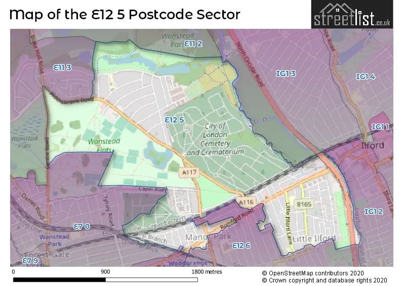
Map of the E12 5 Postcode Sector
Explore the E12 5 postcode sector by using our free interactive map.
| E | 1 | 2 | - | 5 | X | X |
| E | 1 | 2 | Space | 5 | Letter | Letter |
Official List of Streets
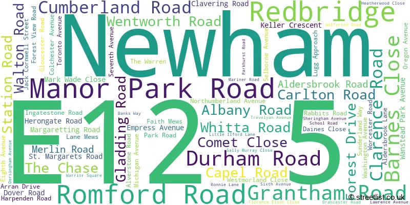
Newham (56 Streets)
Redbridge (18 Streets)
Unofficial Streets or Alternative Spellings
Newham
CARLYLE ROAD CHURCH ROAD FIFTH AVENUE FIRST AVENUE FOURTH AVENUE GREENHILL GROVE HAMPTON ROAD HERBERT ROAD HIGH STREET NORTH MEANLEY ROAD SALISBURY ROAD SEBERT ROAD VERNON AVENUERedbridge
ALDERS CLOSE BRADING CRESCENT LAKE HOUSE ROAD QUEENSWOOD GARDENS WOODLANDS AVENUE ALBURY MEWS ANCHOR ROAD BASSETT ROAD BELFRY ROAD BURGE ROAD CENTRAL AVENUE CENTRE DRIVE CENTRE ROAD CHAPEL AVENUE CHEETHAMS ROAD CHESTNUT AVENUE CHURCH AVENUE CORNWELL CRESCENT DIVISIONAL ROAD EAST BOUNDARY ROAD FARM ROAD FORGES ROAD GARDENS WAY LAPWING TERRACE LAWN DRIVE LIMES AVENUE LINK ROAD MANOR AVENUE MEMORIAL AVENUE NEW ROAD NORTH BOUNDARY ROAD NORTH CIRCULAR ROAD NURSERY ROAD OGDEN HOUSE POPLAR ROAD REMEMBRANCE ROAD RODING VALLEY WAY SOUTH BOUNDARY ROAD SOUTH DRIVE SOUTHGATE ROAD ST ANDREWS ROAD ST DIONIS ROAD SUNDIAL ROAD WILLOW ROAD WOODLAND AVENUE WYMANS WAYILFORD
ILFORD HILLWeather Forecast for E12 5
Press Button to Show Forecast for Ilford
| Time Period | Icon | Description | Temperature | Rain Probability | Wind |
|---|---|---|---|---|---|
| 06:00 to 09:00 | Sunny day | 10.0°C (feels like 9.0°C) | 1.00% | SE 4 mph | |
| 09:00 to 12:00 | Sunny day | 15.0°C (feels like 13.0°C) | 3.00% | SE 9 mph | |
| 12:00 to 15:00 | Cloudy | 16.0°C (feels like 14.0°C) | 8.00% | SSE 11 mph | |
| 15:00 to 18:00 | Cloudy | 16.0°C (feels like 14.0°C) | 10.00% | SSE 11 mph | |
| 18:00 to 21:00 | Cloudy | 15.0°C (feels like 14.0°C) | 10.00% | SSE 7 mph | |
| 21:00 to 00:00 | Partly cloudy (night) | 13.0°C (feels like 12.0°C) | 8.00% | SE 4 mph |
Press Button to Show Forecast for Ilford
| Time Period | Icon | Description | Temperature | Rain Probability | Wind |
|---|---|---|---|---|---|
| 00:00 to 03:00 | Cloudy | 12.0°C (feels like 11.0°C) | 9.00% | SE 4 mph | |
| 03:00 to 06:00 | Cloudy | 11.0°C (feels like 10.0°C) | 8.00% | SSE 4 mph | |
| 06:00 to 09:00 | Cloudy | 11.0°C (feels like 11.0°C) | 10.00% | SSW 4 mph | |
| 09:00 to 12:00 | Cloudy | 13.0°C (feels like 13.0°C) | 11.00% | ENE 4 mph | |
| 12:00 to 15:00 | Cloudy | 16.0°C (feels like 16.0°C) | 11.00% | ESE 4 mph | |
| 15:00 to 18:00 | Cloudy | 17.0°C (feels like 16.0°C) | 14.00% | E 7 mph | |
| 18:00 to 21:00 | Cloudy | 16.0°C (feels like 15.0°C) | 10.00% | ESE 9 mph | |
| 21:00 to 00:00 | Cloudy | 14.0°C (feels like 13.0°C) | 10.00% | N 7 mph |
Press Button to Show Forecast for Ilford
| Time Period | Icon | Description | Temperature | Rain Probability | Wind |
|---|---|---|---|---|---|
| 00:00 to 03:00 | Light rain shower (night) | 12.0°C (feels like 11.0°C) | 45.00% | N 7 mph | |
| 03:00 to 06:00 | Overcast | 11.0°C (feels like 10.0°C) | 21.00% | NNW 7 mph | |
| 06:00 to 09:00 | Overcast | 11.0°C (feels like 10.0°C) | 16.00% | NW 7 mph | |
| 09:00 to 12:00 | Cloudy | 14.0°C (feels like 12.0°C) | 11.00% | NW 7 mph | |
| 12:00 to 15:00 | Partly cloudy (day) | 17.0°C (feels like 16.0°C) | 5.00% | NW 9 mph | |
| 15:00 to 18:00 | Partly cloudy (day) | 19.0°C (feels like 17.0°C) | 5.00% | N 9 mph | |
| 18:00 to 21:00 | Partly cloudy (day) | 18.0°C (feels like 16.0°C) | 5.00% | N 9 mph | |
| 21:00 to 00:00 | Partly cloudy (night) | 14.0°C (feels like 13.0°C) | 5.00% | NW 9 mph |
Schools and Places of Education Within the E12 5 Postcode Sector
Aldersbrook Primary School
Community school
Harpenden Road, London, Essex, E12 5HL
Head: Julie Crouch
Ofsted Rating: Outstanding
Inspection: 2014-12-03 (3436 days ago)
Website: Visit Aldersbrook Primary School Website
Phone: 02089890210
Number of Pupils: 679
Dersingham Primary School
Community school
Dersingham Avenue, Manor Park, London, London, , E12 5QJ
Head: Mr Lando Du Plooy
Ofsted Rating: Good
Inspection: 2019-06-12 (1784 days ago)
Website: Visit Dersingham Primary School Website
Phone: 07939940037
Number of Pupils: 624
Sheringham Nursery School & Children's Centre
Local authority nursery school
Sheringham Avenue, London, , E12 5PB
Head: Miss Lindsey Foster
Ofsted Rating: Outstanding
Inspection: 2018-10-31 (2008 days ago)
Website: Visit Sheringham Nursery School & Children's Centre Website
Phone: 02085532479
Number of Pupils: 179
Sir John Heron Primary School
Community school
School Road, London, , E12 5PY
Head: Ms Nazia Ishaq
Ofsted Rating: Good
Inspection: 2022-05-19 (712 days ago)
Website: Visit Sir John Heron Primary School Website
Phone: 02085149860
Number of Pupils: 468
House Prices in the E12 5 Postcode Sector
| Type of Property | 2018 Average | 2018 Sales | 2017 Average | 2017 Sales | 2016 Average | 2016 Sales | 2015 Average | 2015 Sales |
|---|---|---|---|---|---|---|---|---|
| Detached | £1,301,000 | 1 | £785,333 | 3 | £781,375 | 4 | £651,666 | 3 |
| Semi-Detached | £856,500 | 5 | £890,404 | 13 | £647,000 | 6 | £479,969 | 8 |
| Terraced | £495,631 | 62 | £525,790 | 55 | £454,657 | 77 | £403,623 | 83 |
| Flats | £269,511 | 28 | £266,979 | 49 | £233,825 | 67 | £202,919 | 74 |
Important Postcodes E12 5 in the Postcode Sector
E12 5AA is the postcode for Royal Mail, Manor Park Delivery Office, Manor Park Road
E12 5AD is the postcode for London Borough of Newham, Manor Park Library, 685-691 Romford Road
E12 5AF is the postcode for Salisbury Primary School, Romford Road, and LONDON BOROUGH OF NEWHAM, Salisbury Primary School, Romford Road
E12 5DL is the postcode for Aldersbrook Medical Centre, 65 Aldersbrook Road
E12 5DQ is the postcode for City of London Cemetery & Crematorium, Aldersbrook Road, and MAIN OFFICES, City of London Cemetery & Crematorium, Aldersbrook Road
E12 5HH is the postcode for Corporation of London, Wanstead Playing Fields, Aldersbrook Road
E12 5HL is the postcode for Aldersbrook Primary School, Harpenden Road, Aldersbrook Primary School, Harpenden Road, Wanstead, and INFANT BLOCK, Aldersbrook Primary School, Harpenden Road
E12 5LN is the postcode for Tunnelling and Underground Construction Academy, ALDERSBROOK SIDINGS, LUGG APPROACH
E12 5PB is the postcode for LONDON BOROUGH OF NEWHAM, Sheringham Primary School, Sheringham Avenue, Sheringham Primary School, Sheringham Avenue, and Sheringham Nursery School, Sheringham Avenue
E12 5PY is the postcode for Sir John Heron Primary School, School Road, and LONDON BOROUGH OF NEWHAM, Sir John Heron Primary School, School Road
E12 5QJ is the postcode for Dersingham Primary School, Dersingham Avenue
E12 5QP is the postcode for Dersingham Infant School, Lawrence Avenue
| The E12 5 Sector is within these Local Authorities |
|
|---|---|
| The E12 5 Sector is within these Counties |
|
| The E12 5 Sector is within these Water Company Areas |
|