The E2 postcode district is a postal district located in the E London - E postcode area with a population of 50,134 residents according to the 2021 England and Wales Census.
The area of the E2 postcode district is 1.08 square miles which is 2.80 square kilometres or 692.90 acres.
Currently, the E2 district has about 962 postcode units spread across 5 geographic postcode sectors.
Given that each sector allows for 400 unique postcode combinations, the district has a capacity of 2,000 postcodes. With 962 postcodes already in use, this leaves 1038 units available.
The largest settlements in the E2 postal code are LONDON and HACKNEY.
The E2 Postcode shares a border with E1 (LONDON), E8 (HACKNEY) and N1 (ISLINGTON, HACKNEY).
The primary settlement in the E2 postcode district is Tower Hamlets, located in Greater London. The most significant post town in this district is London, which is also in Greater London. Hackney is another significant settlement in the E2 postcode district, located within Greater London.
For the district E2, we have data on 6 postcode sectors. Here's a breakdown: The sector E2 0, covers Tower Hamlets in Greater London. The sector E2 2 is non-geographic. It's often designated for PO Boxes, large organisations, or special services. The sector E2 6, covers Tower Hamlets in Greater London. The sector E2 7, covers Tower Hamlets in Greater London. The sector E2 8, covers Hackney in Greater London. The sector E2 9, covers Tower Hamlets in Greater London.

Map of the E2 Postcode District
Explore the E2 postcode district by using our free interactive map.
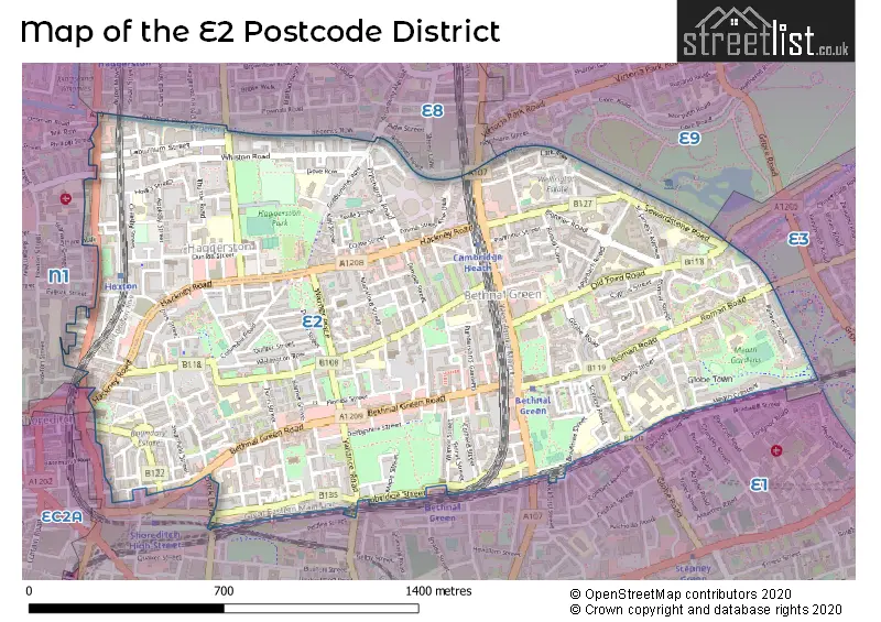
When it comes to local government, postal geography often disregards political borders. However, for a breakdown in the E2 District: the district mostly encompasses the Tower Hamlets London Boro (786 postcodes), and finally, the Hackney London Boro area (196 postcodes).
Recent House Sales in E2
| Date | Price | Address |
|---|---|---|
| 16/10/2023 | £395,000 | Ada Place, London, E2 9BB |
| 13/10/2023 | £851,000 | Kingsland Road, London, E2 8DY |
| 25/09/2023 | £750,000 | Pritchards Road, London, E2 9AW |
| 19/09/2023 | £325,000 | Wilmot Street, London, E2 0BU |
| 19/09/2023 | £660,000 | Kedleston Walk, London, E2 9RP |
| 13/09/2023 | £470,000 | Chambord Street, London, E2 7LL |
| 08/09/2023 | £675,000 | Claredale Street, London, E2 6PG |
| 07/09/2023 | £700,000 | Pritchards Road, London, E2 9BJ |
| 07/09/2023 | £1,270,000 | Quilter Street, London, E2 7BT |
| 01/09/2023 | £1,200,000 | Durant Street, London, E2 7BP |
Weather Forecast for E2
Press Button to Show Forecast for Islington
| Time Period | Icon | Description | Temperature | Rain Probability | Wind |
|---|---|---|---|---|---|
| 00:00 to 03:00 | Light rain | 8.0°C (feels like 6.0°C) | 47.00% | ENE 9 mph | |
| 03:00 to 06:00 | Heavy rain | 7.0°C (feels like 4.0°C) | 86.00% | NE 9 mph | |
| 06:00 to 09:00 | Light rain | 6.0°C (feels like 4.0°C) | 62.00% | NE 9 mph | |
| 09:00 to 12:00 | Overcast | 8.0°C (feels like 5.0°C) | 16.00% | NE 9 mph | |
| 12:00 to 15:00 | Overcast | 11.0°C (feels like 9.0°C) | 13.00% | NE 7 mph | |
| 15:00 to 18:00 | Cloudy | 12.0°C (feels like 11.0°C) | 18.00% | ENE 7 mph | |
| 18:00 to 21:00 | Light rain | 12.0°C (feels like 10.0°C) | 81.00% | NE 9 mph | |
| 21:00 to 00:00 | Heavy rain | 10.0°C (feels like 8.0°C) | 91.00% | NE 9 mph |
Press Button to Show Forecast for Islington
| Time Period | Icon | Description | Temperature | Rain Probability | Wind |
|---|---|---|---|---|---|
| 00:00 to 03:00 | Heavy rain | 9.0°C (feels like 7.0°C) | 91.00% | NNE 9 mph | |
| 03:00 to 06:00 | Heavy rain | 9.0°C (feels like 7.0°C) | 92.00% | NE 9 mph | |
| 06:00 to 09:00 | Light rain | 9.0°C (feels like 7.0°C) | 57.00% | NNW 7 mph | |
| 09:00 to 12:00 | Heavy rain | 9.0°C (feels like 7.0°C) | 83.00% | W 9 mph | |
| 12:00 to 15:00 | Light rain | 9.0°C (feels like 7.0°C) | 57.00% | WNW 11 mph | |
| 15:00 to 18:00 | Cloudy | 10.0°C (feels like 8.0°C) | 14.00% | W 11 mph | |
| 18:00 to 21:00 | Cloudy | 11.0°C (feels like 9.0°C) | 8.00% | WSW 9 mph | |
| 21:00 to 00:00 | Partly cloudy (night) | 9.0°C (feels like 8.0°C) | 4.00% | SW 7 mph |
Press Button to Show Forecast for Islington
| Time Period | Icon | Description | Temperature | Rain Probability | Wind |
|---|---|---|---|---|---|
| 00:00 to 03:00 | Clear night | 8.0°C (feels like 7.0°C) | 2.00% | SW 4 mph | |
| 03:00 to 06:00 | Clear night | 7.0°C (feels like 5.0°C) | 1.00% | SSW 4 mph | |
| 06:00 to 09:00 | Sunny day | 7.0°C (feels like 6.0°C) | 1.00% | S 4 mph | |
| 09:00 to 12:00 | Partly cloudy (day) | 12.0°C (feels like 10.0°C) | 1.00% | S 9 mph | |
| 12:00 to 15:00 | Cloudy | 14.0°C (feels like 12.0°C) | 6.00% | S 11 mph | |
| 15:00 to 18:00 | Partly cloudy (day) | 15.0°C (feels like 13.0°C) | 3.00% | S 11 mph | |
| 18:00 to 21:00 | Sunny day | 14.0°C (feels like 12.0°C) | 3.00% | S 9 mph | |
| 21:00 to 00:00 | Clear night | 11.0°C (feels like 10.0°C) | 1.00% | SSE 7 mph |
Press Button to Show Forecast for Islington
| Time Period | Icon | Description | Temperature | Rain Probability | Wind |
|---|---|---|---|---|---|
| 00:00 to 03:00 | Clear night | 10.0°C (feels like 8.0°C) | 1.00% | SE 7 mph | |
| 03:00 to 06:00 | Clear night | 9.0°C (feels like 8.0°C) | 2.00% | ESE 7 mph | |
| 06:00 to 09:00 | Cloudy | 9.0°C (feels like 8.0°C) | 7.00% | ESE 7 mph | |
| 09:00 to 12:00 | Cloudy | 13.0°C (feels like 11.0°C) | 5.00% | ESE 7 mph | |
| 12:00 to 15:00 | Cloudy | 16.0°C (feels like 14.0°C) | 9.00% | SE 9 mph | |
| 15:00 to 18:00 | Cloudy | 17.0°C (feels like 15.0°C) | 11.00% | SE 9 mph | |
| 18:00 to 21:00 | Cloudy | 16.0°C (feels like 14.0°C) | 10.00% | SE 9 mph | |
| 21:00 to 00:00 | Light rain shower (night) | 13.0°C (feels like 12.0°C) | 34.00% | ESE 7 mph |
Where is the E2 Postcode District?
The E2 postcode district is located in the town of London. It is approximately 3.23 miles away from the center of London. The nearest towns to E2 are Hackney, Barbican, Holborn and Covent Garden, Queen Elizabeth Olympic Park, Islington, and Bromley by Bow.
The district is within the post town of LONDON.
The sector has postcodes within the nation of England.
The E2 Postcode District is covers the following regions.
- Tower Hamlets - Inner London - East - London
- Hackney and Newham - Inner London - East - London
| Postcode Sector | Delivery Office |
|---|---|
| E2 0 | Bethnal Green Sdelivery Office |
| E2 6 | Bethnal Green Sdelivery Office |
| E2 7 | Bethnal Green Sdelivery Office |
| E2 8 | Bethnal Green Sdelivery Office |
| E2 9 | Bethnal Green Sdelivery Office |
| E | 2 | - | X | X | X |
| E | 2 | Space | Numeric | Letter | Letter |
Tourist Attractions within the Postcode Area
We found 1 visitor attractions within the E2 postcode area
| Museum of Childhood at Bethnal Green |
|---|
| Museums & Art Galleries |
| Museum and / or Art Gallery |
| View Museum of Childhood at Bethnal Green on Google Maps |
Current Monthly Rental Prices
| # Bedrooms | Min Price | Max Price | Avg Price |
|---|---|---|---|
| £125 | £7,129 | £1,589 | |
| 1 | £1,075 | £7,883 | £2,486 |
| 2 | £2,000 | £8,024 | £3,116 |
| 3 | £2,400 | £9,000 | £4,434 |
| 4 | £3,200 | £4,600 | £3,977 |
| 5 | £4,000 | £4,000 | £4,000 |
Current House Prices
| # Bedrooms | Min Price | Max Price | Avg Price |
|---|---|---|---|
| £25,000 | £7,000,000 | £1,604,158 | |
| 1 | £299,995 | £800,000 | £460,890 |
| 2 | £234,500 | £1,275,000 | £595,853 |
| 3 | £410,000 | £3,000,000 | £833,202 |
| 4 | £810,000 | £4,250,000 | £1,492,917 |
| 5 | £600,000 | £4,250,000 | £2,425,000 |
| 6 | £2,500,000 | £2,500,000 | £2,500,000 |
Estate Agents who Operate in the E2 District
| Logo | Name | Brand Name | Address | Contact Number | Total Properties |
|---|---|---|---|---|---|
 | Shoreditch | Foxtons | 86 - 90 Curtain Rd, London EC2A 3AA | 020 3909 6725 | 62 |
 | Shoreditch | Dexters | 44 Great Eastern Street London EC2A 3EP | 020 7483 6372 | 36 |
 | Vonder | Vonder | 60 Welbeck Street, London, W1G 9XB | 020 3871 0492 | 27 |
 | Bethnal Green | Elms Estates | 454 Bethnal Green Road, London, E2 0EA | 020 3906 1037 | 19 |
 | London | OpenRent | 39 Great Windmill Street London W1D 7LX | 020 3322 3265 | 18 |
| Type of Property | 2018 Average | 2018 Sales | 2017 Average | 2017 Sales | 2016 Average | 2016 Sales | 2015 Average | 2015 Sales |
|---|---|---|---|---|---|---|---|---|
| Detached | £1,140,000 | 1 | £0 | 0 | £0 | 0 | £525,000 | 1 |
| Semi-Detached | £0 | 0 | £702,500 | 2 | £0 | 0 | £620,000 | 1 |
| Terraced | £991,735 | 35 | £858,225 | 39 | £986,887 | 42 | £805,939 | 41 |
| Flats | £488,042 | 314 | £525,317 | 535 | £514,396 | 541 | £455,429 | 521 |