The E9 5 postcode sector is within the county of Greater London.
Did you know? According to the 2021 Census, the E9 5 postcode sector is home to a bustling 14,460 residents!
Given that each sector allows for 400 unique postcode combinations. Letters C, I, K, M, O and V are not allowed in the last two letters of a postcode. With 243 postcodes already in use, this leaves 157 units available.
The largest settlements in the E9 5 postal code are HACKNEY and LONDON .
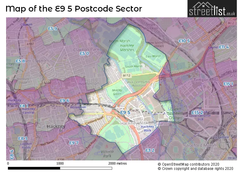
The E9 5 Postcode shares a border with E9 6 (HACKNEY ), E10 5 (LEYTON ), E15 2 (STRATFORD ), E3 2 (LONDON ), E5 0 (HACKNEY ) and E9 7 (HACKNEY ).
The sector is within the post town of LONDON.
E9 5 is a postcode sector within the E9 postcode district which is within the E East London postcode area.
The Royal Mail delivery office for the E9 5 postal sector is the Homerton Sdelivery Office.
The area of the E9 5 postcode sector is 1.01 square miles which is 2.61 square kilometres or 646.11 square acres.
Waterways within the E9 5 postcode sector include the Lee Navigation.

Map of the E9 5 Postcode Sector
Explore the E9 5 postcode sector by using our free interactive map.
| E | 9 | - | 5 | X | X |
| E | 9 | Space | 5 | Letter | Letter |
Official List of Streets
Hackney (72 Streets)
Unofficial Streets or Alternative Spellings
Hackney
ADLEY STREET BERGER ROAD COOPERSALE ROAD DAUBENEY ROAD FLANDERS WAY GASCOYNE ROAD GLASKIN MEWS GLYN ROAD MACKINTOSH LANE MEESON STREET QUEEN ANNE ROAD RODING ROAD TREHURST STREET WATERDEN ROADTower Hamlets
CLARNICO LANE WICK LANEWaltham Forest
RUCKHOLT ROADWeather Forecast for E9 5
Press Button to Show Forecast for London Olympic Park North
| Time Period | Icon | Description | Temperature | Rain Probability | Wind |
|---|---|---|---|---|---|
| 15:00 to 18:00 | Overcast | 12.0°C (feels like 11.0°C) | 9.00% | E 7 mph | |
| 18:00 to 21:00 | Cloudy | 11.0°C (feels like 9.0°C) | 9.00% | E 9 mph | |
| 21:00 to 00:00 | Cloudy | 9.0°C (feels like 7.0°C) | 9.00% | E 9 mph |
Press Button to Show Forecast for London Olympic Park North
| Time Period | Icon | Description | Temperature | Rain Probability | Wind |
|---|---|---|---|---|---|
| 00:00 to 03:00 | Overcast | 8.0°C (feels like 6.0°C) | 18.00% | ENE 9 mph | |
| 03:00 to 06:00 | Heavy rain | 7.0°C (feels like 5.0°C) | 79.00% | ENE 9 mph | |
| 06:00 to 09:00 | Light rain | 7.0°C (feels like 4.0°C) | 57.00% | NE 7 mph | |
| 09:00 to 12:00 | Overcast | 8.0°C (feels like 5.0°C) | 14.00% | NE 9 mph | |
| 12:00 to 15:00 | Overcast | 11.0°C (feels like 10.0°C) | 13.00% | NE 7 mph | |
| 15:00 to 18:00 | Cloudy | 13.0°C (feels like 11.0°C) | 12.00% | ENE 7 mph | |
| 18:00 to 21:00 | Heavy rain | 12.0°C (feels like 10.0°C) | 81.00% | ENE 9 mph | |
| 21:00 to 00:00 | Heavy rain | 10.0°C (feels like 8.0°C) | 86.00% | NE 9 mph |
Press Button to Show Forecast for London Olympic Park North
| Time Period | Icon | Description | Temperature | Rain Probability | Wind |
|---|---|---|---|---|---|
| 00:00 to 03:00 | Heavy rain | 9.0°C (feels like 7.0°C) | 89.00% | NNE 11 mph | |
| 03:00 to 06:00 | Heavy rain | 9.0°C (feels like 7.0°C) | 89.00% | NNE 9 mph | |
| 06:00 to 09:00 | Heavy rain | 9.0°C (feels like 7.0°C) | 85.00% | N 7 mph | |
| 09:00 to 12:00 | Light rain | 9.0°C (feels like 7.0°C) | 58.00% | WNW 9 mph | |
| 12:00 to 15:00 | Light rain | 10.0°C (feels like 7.0°C) | 55.00% | WNW 11 mph | |
| 15:00 to 18:00 | Cloudy | 11.0°C (feels like 9.0°C) | 18.00% | W 11 mph | |
| 18:00 to 21:00 | Cloudy | 11.0°C (feels like 9.0°C) | 10.00% | WSW 9 mph | |
| 21:00 to 00:00 | Partly cloudy (night) | 10.0°C (feels like 8.0°C) | 6.00% | SW 7 mph |
Press Button to Show Forecast for London Olympic Park North
| Time Period | Icon | Description | Temperature | Rain Probability | Wind |
|---|---|---|---|---|---|
| 00:00 to 03:00 | Partly cloudy (night) | 8.0°C (feels like 7.0°C) | 2.00% | SW 4 mph | |
| 03:00 to 06:00 | Clear night | 7.0°C (feels like 5.0°C) | 1.00% | SSW 4 mph | |
| 06:00 to 09:00 | Sunny day | 7.0°C (feels like 6.0°C) | 1.00% | S 4 mph | |
| 09:00 to 12:00 | Sunny day | 12.0°C (feels like 10.0°C) | 1.00% | S 9 mph | |
| 12:00 to 15:00 | Cloudy | 14.0°C (feels like 12.0°C) | 8.00% | S 11 mph | |
| 15:00 to 18:00 | Partly cloudy (day) | 15.0°C (feels like 13.0°C) | 4.00% | S 11 mph | |
| 18:00 to 21:00 | Sunny day | 14.0°C (feels like 12.0°C) | 4.00% | S 9 mph | |
| 21:00 to 00:00 | Clear night | 11.0°C (feels like 10.0°C) | 1.00% | SSE 7 mph |
Press Button to Show Forecast for London Olympic Park North
| Time Period | Icon | Description | Temperature | Rain Probability | Wind |
|---|---|---|---|---|---|
| 00:00 to 03:00 | Clear night | 10.0°C (feels like 9.0°C) | 1.00% | SE 7 mph | |
| 03:00 to 06:00 | Clear night | 9.0°C (feels like 8.0°C) | 3.00% | ESE 7 mph | |
| 06:00 to 09:00 | Partly cloudy (day) | 9.0°C (feels like 8.0°C) | 5.00% | ESE 7 mph | |
| 09:00 to 12:00 | Cloudy | 13.0°C (feels like 12.0°C) | 7.00% | ESE 7 mph | |
| 12:00 to 15:00 | Cloudy | 16.0°C (feels like 14.0°C) | 11.00% | SE 9 mph | |
| 15:00 to 18:00 | Cloudy | 17.0°C (feels like 15.0°C) | 13.00% | SE 9 mph | |
| 18:00 to 21:00 | Cloudy | 16.0°C (feels like 14.0°C) | 11.00% | SE 9 mph | |
| 21:00 to 00:00 | Light rain shower (night) | 14.0°C (feels like 13.0°C) | 35.00% | ESE 7 mph |
Schools and Places of Education Within the E9 5 Postcode Sector
Gainsborough Primary School
Community school
Berkshire Road, London, , E9 5ND
Head: Ms Jenna Clark
Ofsted Rating: Good
Inspection: 2023-06-15 (316 days ago)
Website: Visit Gainsborough Primary School Website
Phone: 02089854622
Number of Pupils: 273
Ickburgh School
Community special school
Kenworthy Road, London, , E9 5RB
Head: Mr Joseph Sieber
Ofsted Rating: Good
Inspection: 2023-06-29 (302 days ago)
Website: Visit Ickburgh School Website
Phone: 02088064638
Number of Pupils: 156
Kingsmead Primary School
Community school
Kingsmead Way, London, , E9 5PP
Head: Ms Louise Nichols
Ofsted Rating: Outstanding
Inspection: 2023-11-23 (155 days ago)
Website: Visit Kingsmead Primary School Website
Phone: 02089855779
Number of Pupils: 225
St. Dominic's Catholic Primary School
Voluntary aided school
Ballance Road, London, , E9 5SR
Head: Ms Deirdre Finan
Ofsted Rating: Good
Inspection: 2023-03-29 (394 days ago)
Website: Visit St. Dominic's Catholic Primary School Website
Phone: 02089850995
Number of Pupils: 274
Wentworth Nursery School and Children's Centre
Local authority nursery school
Cassland Road, London, , E9 5BY
Head: Ms Farzana Chowdhury
Ofsted Rating: Outstanding
Inspection: 2023-04-26 (366 days ago)
Website: Visit Wentworth Nursery School and Children's Centre Website
Phone: 02089853491
Number of Pupils: 91
House Prices in the E9 5 Postcode Sector
| Type of Property | 2018 Average | 2018 Sales | 2017 Average | 2017 Sales | 2016 Average | 2016 Sales | 2015 Average | 2015 Sales |
|---|---|---|---|---|---|---|---|---|
| Detached | £0 | 0 | £0 | 0 | £0 | 0 | £0 | 0 |
| Semi-Detached | £0 | 0 | £680,000 | 1 | £0 | 0 | £0 | 0 |
| Terraced | £779,233 | 15 | £698,682 | 22 | £675,179 | 36 | £604,257 | 29 |
| Flats | £382,714 | 61 | £393,070 | 87 | £363,014 | 82 | £319,806 | 105 |
Important Postcodes E9 5 in the Postcode Sector
E9 5AN is the postcode for The Wick Health Centre, 200 Wick Road
E9 5DU is the postcode for The Eastern Hub, Victoria Park
E9 5HT is the postcode for Victoria Park Sports Pavilion, St. Mark's Gate
E9 5LD is the postcode for 1 Trowbridge Road
E9 5LG is the postcode for Unit B/1, 30, Felstead Street
E9 5ND is the postcode for Gainsborough Primary School, Berkshire Road
E9 5PF is the postcode for Hackney Marshes North Pavillion, Homerton Road, Hackney Marshes Sports Centre, Homerton Road, Hackney Marshes Centre, Hackney Marshes, Homerton Road, and NORTH MARSHES CHANGING ROOMS, Hackney Marshes Sports Centre, Homerton Road
E9 5PP is the postcode for Kingsmead Primary School, Kingsmead Way
E9 5RB is the postcode for New Ickburgh School, Kenworthy Road, and Cardinal Pole RC School, Kenworthy Road
E9 5SR is the postcode for St. Dominic RC Primary School, Ballance Road, INFANTS SCHOOL, St. Dominic RC Primary School, Ballance Road, and JUNIOR SCHOOL, St. Dominic RC Primary School, Ballance Road
E9 5TD is the postcode for JOHN WARBURTON BUILDING, East London Mental Health Trust, John Howard Centre, 12 Kenworthy Road, East London Mental Health Trust, Beaumont Building, 12 Kenworthy Road, East London Mental Health Trust, Elizabeth Fry Building, East London Mental Health Trust, Whitbread Building, Kenworthy Road Health Centre, 10 Kenworthy Road, East London Mental Health Trust, Whitbread Building, 12 Kenworthy Road, East London Mental Health Trust, Millfield Unit, East London Mental Health Trust, Elizabeth Fry Building, 12 Kenworthy Road, KENWORTHY ROAD HEALTH CENTRE, 10 KENWORTHY ROAD, HACKNEY, East London Mental Health Trust, Millfield Unit, 12 Kenworthy Road, East London Mental Health Trust, John Howard Centre, 12 Kenworthy Road, East London Mental Health Trust, Beaumont Building, East London NHS Foundation Trust, 12 Kenworthy Road, and RECEPTION, East London Mental Health Trust, John Howard Centre, 12 Kenworthy Road
| The E9 5 Sector is within these Local Authorities |
|
|---|---|
| The E9 5 Sector is within these Counties |
|
| The E9 5 Sector is within these Water Company Areas |
|