The EN5 5 postcode sector is within the county of Greater London.
Did you know? According to the 2021 Census, the EN5 5 postcode sector is home to a bustling 9,099 residents!
Given that each sector allows for 400 unique postcode combinations. Letters C, I, K, M, O and V are not allowed in the last two letters of a postcode. With 261 postcodes already in use, this leaves 139 units available.
The largest settlement in the EN5 5 postal code is NEW BARNET followed by BARNET , and POTTERS ROAD TO HADLEY COMMON .
The EN5 5 Postcode shares a border with EN5 2 (BARNET , UNDERHILL , CHIPPING BARNET ), EN4 0 (ENFIELD , ENFIELD NORTH ), EN4 8 (EAST BARNET , NEW BARNET , STATION ROAD TO BROOKHILL ROAD ), EN4 9 (NEW BARNET , BARNET , EAST BARNET ), EN5 1 (NEW BARNET , BARNET , UNDERHILL ) and EN5 4 (BARNET , DURY ROAD TO GREAT NORTH ROAD , ARKLEY BARNET SECTION ).
The sector is within the post town of BARNET.
EN5 5 is a postcode sector within the EN4 postcode district which is within the EN Enfield postcode area.
The Royal Mail delivery office for the EN5 5 postal sector is the unknown.
The area of the EN5 5 postcode sector is 1.02 square miles which is 2.63 square kilometres or 649.71 square acres.

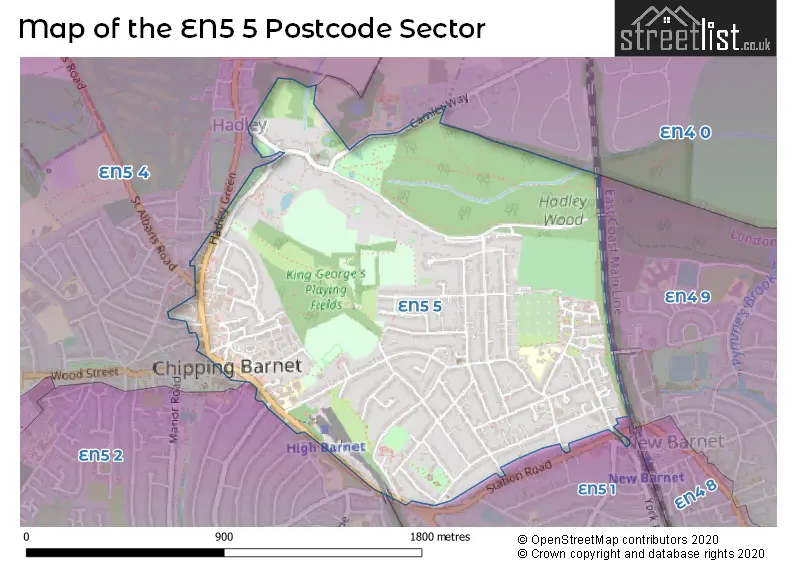
Map of the EN5 5 Postcode Sector
Explore the EN5 5 postcode sector by using our free interactive map.
| E | N | 5 | - | 5 | X | X |
| E | N | 5 | Space | 5 | Letter | Letter |
Official List of Streets
BARNET (65 Streets)
New Barnet (11 Streets)
Unofficial Streets or Alternative Spellings
BARNET
BEDFORD AVENUE CAMLET WAY CHRIST CHURCH LANE EAST BARNET ROAD FAIRFIELD WAY FITZJOHN AVENUE HADLEY GREEN MILTON AVENUE NORMANDY AVENUE ROWAN WALK SALISBURY ROAD TODHUNTER TERRACE UNDERHILL UNION STREET WOOD STREETNew Barnet
STATION APPROACH STATION ROAD CHURCH PASSAGE GREAT NORTH ROAD HADLEY COMMON AND BAKERS HILL (NEAR TO) HADLEY MEWS HADLEY WOOD ROAD HIGHWOOD COURT HURST RISE KING GEORGES PLAYING FIELDS MORREL CLOSE NESBITTS ALLEY NURSERY ROW PRESTON COURT RAVENSCROFT COTTAGES ST ALBANS ROAD SYDNEY CHAPMAN WAY THE HIGHLANDS THE SPIRES SHOPPING CENTRE TRIANGLE PASSAGE WESTERN PARADEWeather Forecast for EN5 5
Press Button to Show Forecast for Barnet
| Time Period | Icon | Description | Temperature | Rain Probability | Wind |
|---|---|---|---|---|---|
| 12:00 to 15:00 | Cloudy | 21.0°C (feels like 20.0°C) | 3.00% | ESE 2 mph | |
| 15:00 to 18:00 | Cloudy | 22.0°C (feels like 21.0°C) | 3.00% | E 4 mph | |
| 18:00 to 21:00 | Sunny day | 19.0°C (feels like 17.0°C) | 0.00% | ESE 11 mph | |
| 21:00 to 00:00 | Cloudy | 15.0°C (feels like 14.0°C) | 3.00% | E 7 mph |
Press Button to Show Forecast for Barnet
| Time Period | Icon | Description | Temperature | Rain Probability | Wind |
|---|---|---|---|---|---|
| 00:00 to 03:00 | Clear night | 12.0°C (feels like 11.0°C) | 0.00% | E 7 mph | |
| 03:00 to 06:00 | Cloudy | 10.0°C (feels like 9.0°C) | 3.00% | ENE 4 mph | |
| 06:00 to 09:00 | Cloudy | 10.0°C (feels like 9.0°C) | 8.00% | E 7 mph | |
| 09:00 to 12:00 | Cloudy | 16.0°C (feels like 15.0°C) | 3.00% | E 7 mph | |
| 12:00 to 15:00 | Partly cloudy (day) | 21.0°C (feels like 19.0°C) | 0.00% | ESE 9 mph | |
| 15:00 to 18:00 | Partly cloudy (day) | 22.0°C (feels like 20.0°C) | 0.00% | ESE 9 mph | |
| 18:00 to 21:00 | Cloudy | 19.0°C (feels like 17.0°C) | 3.00% | E 11 mph | |
| 21:00 to 00:00 | Partly cloudy (night) | 15.0°C (feels like 14.0°C) | 0.00% | E 9 mph |
Press Button to Show Forecast for Barnet
| Time Period | Icon | Description | Temperature | Rain Probability | Wind |
|---|---|---|---|---|---|
| 00:00 to 03:00 | Cloudy | 14.0°C (feels like 12.0°C) | 4.00% | E 9 mph | |
| 03:00 to 06:00 | Cloudy | 13.0°C (feels like 12.0°C) | 3.00% | E 7 mph | |
| 06:00 to 09:00 | Cloudy | 13.0°C (feels like 12.0°C) | 3.00% | E 7 mph | |
| 09:00 to 12:00 | Cloudy | 18.0°C (feels like 17.0°C) | 3.00% | ESE 7 mph | |
| 12:00 to 15:00 | Cloudy | 22.0°C (feels like 20.0°C) | 4.00% | SE 9 mph | |
| 15:00 to 18:00 | Cloudy | 22.0°C (feels like 20.0°C) | 11.00% | SSE 9 mph | |
| 18:00 to 21:00 | Cloudy | 20.0°C (feels like 18.0°C) | 13.00% | SSW 7 mph | |
| 21:00 to 00:00 | Cloudy | 17.0°C (feels like 16.0°C) | 11.00% | S 7 mph |
Press Button to Show Forecast for Barnet
| Time Period | Icon | Description | Temperature | Rain Probability | Wind |
|---|---|---|---|---|---|
| 00:00 to 03:00 | Cloudy | 14.0°C (feels like 13.0°C) | 10.00% | SSW 7 mph | |
| 03:00 to 06:00 | Overcast | 13.0°C (feels like 11.0°C) | 13.00% | SSW 9 mph | |
| 06:00 to 09:00 | Overcast | 13.0°C (feels like 11.0°C) | 11.00% | S 9 mph | |
| 09:00 to 12:00 | Cloudy | 15.0°C (feels like 13.0°C) | 10.00% | S 11 mph | |
| 12:00 to 15:00 | Cloudy | 16.0°C (feels like 14.0°C) | 15.00% | S 13 mph | |
| 15:00 to 18:00 | Light rain | 15.0°C (feels like 13.0°C) | 55.00% | SSE 13 mph | |
| 18:00 to 21:00 | Heavy rain | 15.0°C (feels like 12.0°C) | 77.00% | SSE 13 mph | |
| 21:00 to 00:00 | Light rain shower (night) | 13.0°C (feels like 11.0°C) | 44.00% | SSE 11 mph |
Press Button to Show Forecast for Barnet
| Time Period | Icon | Description | Temperature | Rain Probability | Wind |
|---|---|---|---|---|---|
| 00:00 to 03:00 | Light rain | 12.0°C (feels like 10.0°C) | 51.00% | S 9 mph | |
| 03:00 to 06:00 | Overcast | 11.0°C (feels like 9.0°C) | 19.00% | SSE 9 mph | |
| 06:00 to 09:00 | Cloudy | 11.0°C (feels like 9.0°C) | 14.00% | SSE 11 mph | |
| 09:00 to 12:00 | Light rain shower (day) | 13.0°C (feels like 11.0°C) | 32.00% | S 13 mph | |
| 12:00 to 15:00 | Partly cloudy (day) | 15.0°C (feels like 12.0°C) | 10.00% | S 13 mph | |
| 15:00 to 18:00 | Light rain shower (day) | 15.0°C (feels like 12.0°C) | 35.00% | S 13 mph | |
| 18:00 to 21:00 | Light rain shower (day) | 14.0°C (feels like 12.0°C) | 31.00% | S 11 mph | |
| 21:00 to 00:00 | Partly cloudy (night) | 12.0°C (feels like 10.0°C) | 8.00% | S 9 mph |
Schools and Places of Education Within the EN5 5 Postcode Sector
Cromer Road Primary School
Community school
Cromer Road, Barnet, Hertfordshire, EN5 5HT
Head: Mrs Dana O'Donnell
Ofsted Rating: Good
Inspection: 2022-11-23 (534 days ago)
Website: Visit Cromer Road Primary School Website
Phone: 02084493492
Number of Pupils: 415
Queen Elizabeth's Girls' School
Academy converter
High Street, Barnet, Hertfordshire, EN5 5RR
Head: Violet Walker
Ofsted Rating: Good
Inspection: 2021-09-22 (961 days ago)
Website: Visit Queen Elizabeth's Girls' School Website
Phone: 02084492984
Number of Pupils: 1132
House Prices in the EN5 5 Postcode Sector
| Type of Property | 2018 Average | 2018 Sales | 2017 Average | 2017 Sales | 2016 Average | 2016 Sales | 2015 Average | 2015 Sales |
|---|---|---|---|---|---|---|---|---|
| Detached | £1,002,295 | 10 | £904,346 | 13 | £795,775 | 20 | £788,100 | 15 |
| Semi-Detached | £728,828 | 25 | £639,157 | 27 | £723,206 | 34 | £601,715 | 42 |
| Terraced | £438,500 | 21 | £481,104 | 14 | £580,444 | 17 | £430,023 | 22 |
| Flats | £304,248 | 64 | £315,187 | 60 | £336,053 | 94 | £272,530 | 83 |
Important Postcodes EN5 5 in the Postcode Sector
EN5 5HT is the postcode for Cromer Road Jmi School, Cromer Road
EN5 5RR is the postcode for TERRAPIN BLOCK, Queen Elizabeths Girls School, High Street, BLOCK A, Queen Elizabeths Girls School, High Street, and BLOCK C, Queen Elizabeths Girls School, High Street
EN5 5RU is the postcode for Police Station, 26-32 High Street, BARNET POLICE STATION, Police Station, 26-32 High Street, and BARNET POLICE STATION, 26-32 HIGH STREET
EN5 5TS is the postcode for Hadley Wood Hospital, 52 Moxon St, Barnet
EN5 5UJ is the postcode for Barnet & Southgate College, Graseby House
EN5 5UU is the postcode for Post Office, 63-65 High Street
| The EN5 5 Sector is within these Local Authorities |
|
|---|---|
| The EN5 5 Sector is within these Counties |
|
| The EN5 5 Sector is within these Water Company Areas |
|