The EX18 7 postcode sector is within the county of Devon.
Did you know? According to the 2021 Census, the EX18 7 postcode sector is home to a bustling 3,287 residents!
Given that each sector allows for 400 unique postcode combinations. Letters C, I, K, M, O and V are not allowed in the last two letters of a postcode. With 197 postcodes already in use, this leaves 203 units available.
The largest settlement in the EX18 7 postal code is CHULMLEIGH followed by Chawleigh, and Wembworthy.
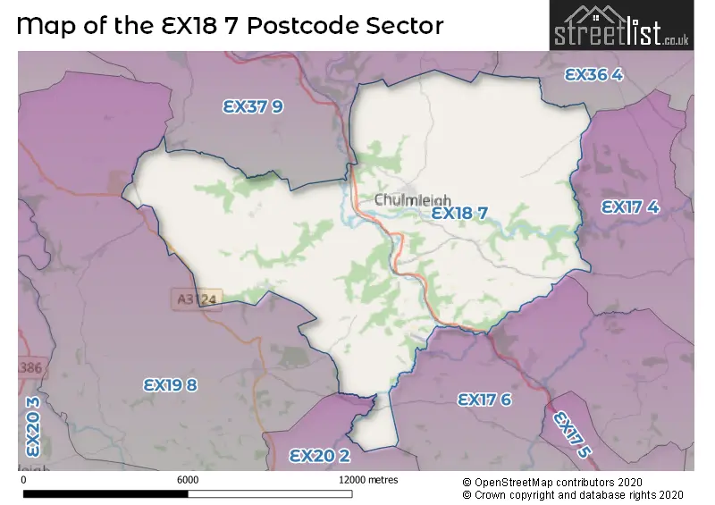
The EX18 7 Postcode shares a border with EX17 4 (Cheriton Fitzpaine, Sandford, Black Dog), EX17 6 (Bow, Lapford, Morchard Bishop), EX19 8 (WINKLEIGH, Dolton, Beaford), EX20 2 (NORTH TAWTON, South Zeal, Sampford Courtenay), EX36 4 (SOUTH MOLTON, Bishops Nympton, Knowstone) and EX37 9 (High Bickington, Chittlehampton, Burrington).
The sector is within the post town of CHULMLEIGH.
EX18 7 is a postcode sector within the EX17 postcode district which is within the EX Exeter postcode area.
The Royal Mail delivery office for the EX18 7 postal sector is the unknown.
The area of the EX18 7 postcode sector is 45.23 square miles which is 117.14 square kilometres or 28,946.58 square acres.
Waterways within the EX18 7 postcode sector include the River Mole, River Yeo, River Taw.


Map of the EX18 7 Postcode Sector
Explore the EX18 7 postcode sector by using our free interactive map.
| E | X | 1 | 8 | - | 7 | X | X |
| E | X | 1 | 8 | Space | 7 | Letter | Letter |
Official List of Streets
CHULMLEIGH (26 Streets)
Ashreigney (6 Streets)
Chawleigh (7 Streets)
Riddlecombe (3 Streets)
Eggesford (4 Streets)
Wembworthy (4 Streets)
Hollocombe (1 Streets)
Unofficial Streets or Alternative Spellings
Schools and Places of Education Within the EX18 7 Postcode Sector
Chulmleigh Community College
Academy converter
Beacon Road, Chulmleigh, Devon, EX18 7AA
Head: Mr Michael Johnson
Ofsted Rating: Good
Inspection: 2023-10-18 (218 days ago)
Website: Visit Chulmleigh Community College Website
Phone: 01769580215
Number of Pupils: 748
Chulmleigh Primary School
Academy converter
Beacon Road, Chulmleigh, Devon, EX18 7AA
Head: Mr Michael Johnson
Ofsted Rating: Good
Inspection: 2023-09-28 (238 days ago)
Website: Visit Chulmleigh Primary School Website
Phone: 01769580535
Number of Pupils: 182
House Prices in the EX18 7 Postcode Sector
| Type of Property | 2018 Average | 2018 Sales | 2017 Average | 2017 Sales | 2016 Average | 2016 Sales | 2015 Average | 2015 Sales |
|---|---|---|---|---|---|---|---|---|
| Detached | £324,996 | 28 | £317,891 | 32 | £308,548 | 30 | £342,420 | 25 |
| Semi-Detached | £214,042 | 19 | £215,968 | 11 | £207,664 | 7 | £200,106 | 9 |
| Terraced | £206,235 | 17 | £191,432 | 19 | £219,393 | 20 | £179,462 | 13 |
| Flats | £115,498 | 3 | £0 | 0 | £128,500 | 2 | £89,167 | 3 |
Important Postcodes EX18 7 in the Postcode Sector
EX18 7AA is the postcode for Newnam Building, The Community College, Sports Hall, The Community College, Road From Bonds Cross To Four Crossways, The Community College, Chulmleigh Cp School, Colleton Building, The Community College, and SPORTS HALL, The Community College
EX18 7DL is the postcode for Wallingbrook Health Centre, Back Lane
| The EX18 7 Sector is within these Local Authorities |
|
|---|---|
| The EX18 7 Sector is within these Counties |
|
| The EX18 7 Sector is within these Water Company Areas |
|