The HA1 postcode district is a postal district located in the HA Harrow postcode area with a population of 45,038 residents according to the 2021 England and Wales Census.
The area of the HA1 postcode district is 3.03 square miles which is 7.85 square kilometres or 1,939.68 acres.
Currently, the HA1 district has about 933 postcode units spread across 4 geographic postcode sectors.
Given that each sector allows for 400 unique postcode combinations, the district has a capacity of 1,600 postcodes. With 933 postcodes already in use, this leaves 667 units available.
The HA1 postal code covers the settlement of HARROW.
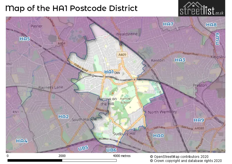
The HA1 Postcode shares a border with HA0 (WEMBLEY), HA2 (HARROW, SOUTH HARROW) and HA3 (HARROW).
The primary settlement in the HA1 postcode district is Harrow, which is located in the county of Greater London. The most significant postal town in this district is Harrow.
For the district HA1, we have data on 5 postcode sectors. Here's a breakdown: The sector HA1 1, covers Harrow in Greater London. The sector HA1 2, covers Harrow in Greater London. The sector HA1 3, covers Harrow in Greater London. The sector HA1 4, covers Harrow in Greater London. The sector HA1 9 is non-geographic. It's often designated for PO Boxes, large organisations, or special services.


Map of the HA1 Postcode District
Explore the HA1 postcode district by using our free interactive map.
When it comes to local government, postal geography often disregards political borders. However, for a breakdown in the HA1 District: the district mostly encompasses the Harrow London Boro (895 postcodes), and finally, the Brent London Boro area (43 postcodes).
Recent House Sales in HA1
| Date | Price | Address |
|---|---|---|
| 19/10/2023 | £400,000 | West Street, Harrow, HA1 3EL |
| 12/10/2023 | £620,000 | Roxborough Park, Harrow, HA1 3AY |
| 02/10/2023 | £825,000 | West Street, Harrow, HA1 3EL |
| 19/09/2023 | £760,000 | Flambard Road, Harrow, HA1 2NB |
| 13/09/2023 | £365,000 | Perceval Square, Harrow, HA1 1ER |
| 12/09/2023 | £207,500 | Francis Road, Harrow, HA1 2QU |
| 08/09/2023 | £535,000 | Hide Road, Harrow, HA1 4SE |
| 06/09/2023 | £345,000 | Lyon Road, Harrow, HA1 2SX |
| 04/09/2023 | £308,000 | Oxford Road, Harrow, HA1 4JQ |
| 31/08/2023 | £665,000 | Welldon Crescent, Harrow, HA1 1QP |
Weather Forecast for HA1
Press Button to Show Forecast for Harrow
| Time Period | Icon | Description | Temperature | Rain Probability | Wind |
|---|---|---|---|---|---|
| 06:00 to 09:00 | Overcast | 9.0°C (feels like 7.0°C) | 56.00% | SW 7 mph | |
| 09:00 to 12:00 | Light rain | 8.0°C (feels like 6.0°C) | 55.00% | W 9 mph | |
| 12:00 to 15:00 | Light rain | 8.0°C (feels like 4.0°C) | 53.00% | W 13 mph | |
| 15:00 to 18:00 | Cloudy | 9.0°C (feels like 6.0°C) | 20.00% | WSW 11 mph | |
| 18:00 to 21:00 | Cloudy | 10.0°C (feels like 8.0°C) | 14.00% | SW 9 mph | |
| 21:00 to 00:00 | Clear night | 8.0°C (feels like 6.0°C) | 1.00% | SW 7 mph |
Press Button to Show Forecast for Harrow
| Time Period | Icon | Description | Temperature | Rain Probability | Wind |
|---|---|---|---|---|---|
| 00:00 to 03:00 | Partly cloudy (night) | 7.0°C (feels like 5.0°C) | 1.00% | SW 7 mph | |
| 03:00 to 06:00 | Clear night | 6.0°C (feels like 4.0°C) | 0.00% | SSW 7 mph | |
| 06:00 to 09:00 | Sunny day | 7.0°C (feels like 5.0°C) | 0.00% | S 7 mph | |
| 09:00 to 12:00 | Cloudy | 12.0°C (feels like 9.0°C) | 4.00% | S 11 mph | |
| 12:00 to 15:00 | Partly cloudy (day) | 14.0°C (feels like 11.0°C) | 3.00% | S 13 mph | |
| 15:00 to 18:00 | Partly cloudy (day) | 15.0°C (feels like 12.0°C) | 2.00% | S 13 mph | |
| 18:00 to 21:00 | Sunny day | 14.0°C (feels like 11.0°C) | 2.00% | S 9 mph | |
| 21:00 to 00:00 | Clear night | 11.0°C (feels like 9.0°C) | 0.00% | SSE 7 mph |
Press Button to Show Forecast for Harrow
| Time Period | Icon | Description | Temperature | Rain Probability | Wind |
|---|---|---|---|---|---|
| 00:00 to 03:00 | Clear night | 9.0°C (feels like 8.0°C) | 1.00% | SE 7 mph | |
| 03:00 to 06:00 | Clear night | 9.0°C (feels like 7.0°C) | 0.00% | ESE 7 mph | |
| 06:00 to 09:00 | Partly cloudy (day) | 9.0°C (feels like 8.0°C) | 1.00% | ESE 7 mph | |
| 09:00 to 12:00 | Partly cloudy (day) | 13.0°C (feels like 12.0°C) | 3.00% | SE 7 mph | |
| 12:00 to 15:00 | Light rain shower (day) | 16.0°C (feels like 14.0°C) | 30.00% | SSE 9 mph | |
| 15:00 to 18:00 | Light rain shower (day) | 16.0°C (feels like 14.0°C) | 32.00% | SSE 9 mph | |
| 18:00 to 21:00 | Cloudy | 15.0°C (feels like 14.0°C) | 11.00% | SE 7 mph | |
| 21:00 to 00:00 | Cloudy | 13.0°C (feels like 12.0°C) | 15.00% | ESE 7 mph |
Press Button to Show Forecast for Harrow
| Time Period | Icon | Description | Temperature | Rain Probability | Wind |
|---|---|---|---|---|---|
| 00:00 to 03:00 | Cloudy | 12.0°C (feels like 11.0°C) | 15.00% | ESE 4 mph | |
| 03:00 to 06:00 | Cloudy | 11.0°C (feels like 10.0°C) | 11.00% | E 4 mph | |
| 06:00 to 09:00 | Fog | 11.0°C (feels like 10.0°C) | 21.00% | E 4 mph | |
| 09:00 to 12:00 | Cloudy | 14.0°C (feels like 13.0°C) | 14.00% | E 4 mph | |
| 12:00 to 15:00 | Cloudy | 17.0°C (feels like 16.0°C) | 13.00% | E 7 mph | |
| 15:00 to 18:00 | Cloudy | 19.0°C (feels like 17.0°C) | 14.00% | ESE 7 mph | |
| 18:00 to 21:00 | Cloudy | 17.0°C (feels like 16.0°C) | 11.00% | SSE 7 mph | |
| 21:00 to 00:00 | Cloudy | 14.0°C (feels like 13.0°C) | 11.00% | NE 7 mph |
Where is the HA1 Postcode District?
The postcode district HA1 is located in Harrow, which is a town in London. Harrow is situated approximately 10.21 miles away from the center of London. It is surrounded by several nearby towns, including Harrow on the Hill to the southeast (0.22 miles), West Harrow to the west (0.59 miles), Northwick Park to the east (0.80 miles), Sudbury Hill to the south (1.27 miles), Wealdstone to the north (1.37 miles), South Harrow to the southwest (1.44 miles), and Kenton to the northeast (1.64 miles).
The district is within the post town of HARROW.
The sector has postcodes within the nation of England.
The HA1 Postcode District is covers the following regions.
- Harrow and Hillingdon - Outer London - West and North West - London
- Brent - Outer London - West and North West - London
| Postcode Sector | Delivery Office |
|---|---|
| HA1 1 | Harrow Central Delivery Office |
| HA1 2 | Harrow Central Delivery Office |
| HA1 3 | Harrow Central Delivery Office |
| HA1 4 | Harrow Central Delivery Office |
| H | A | 1 | - | X | X | X |
| H | A | 1 | Space | Numeric | Letter | Letter |
Tourist Attractions within the Postcode Area
We found 1 visitor attractions within the HA1 postcode area
| Harrow School Old Speech Room Gallery |
|---|
| Museums & Art Galleries |
| Museum and / or Art Gallery |
| View Harrow School Old Speech Room Gallery on Google Maps |
Current Monthly Rental Prices
| # Bedrooms | Min Price | Max Price | Avg Price |
|---|---|---|---|
| £800 | £1,400 | £1,091 | |
| 1 | £650 | £5,100 | £1,665 |
| 2 | £1,400 | £5,100 | £2,091 |
| 3 | £1,900 | £5,417 | £2,696 |
| 4 | £2,300 | £8,233 | £4,027 |
| 5 | £5,000 | £10,833 | £7,917 |
| 6 | £4,900 | £4,900 | £4,900 |
| 7 | £14,000 | £15,000 | £14,500 |
Current House Prices
| # Bedrooms | Min Price | Max Price | Avg Price |
|---|---|---|---|
| £32,500 | £1,100,000 | £275,808 | |
| 1 | £80,000 | £445,999 | £261,863 |
| 2 | £102,500 | £585,000 | £406,670 |
| 3 | £345,000 | £1,700,000 | £621,967 |
| 4 | £400,000 | £1,450,000 | £935,398 |
| 5 | £675,000 | £2,750,000 | £1,029,370 |
| 6 | £700,000 | £2,375,000 | £1,535,667 |
| 7 | £4,395,000 | £4,395,000 | £4,395,000 |
Estate Agents who Operate in the HA1 District
| Logo | Name | Brand Name | Address | Contact Number | Total Properties |
|---|---|---|---|---|---|
 | Harrow | Foxtons | 321 Station Road, Harrow, HA1 2AA | 020 3910 6604 | 76 |
 | Harrow | Brian Cox | 310 Station Road, Harrow, HA1 2DX | 020 3840 3656 | 24 |
 | Harrow Sales | Gibbs Gillespie | 303 - 305 Rayners Lane, HA5 5EH | 020 3909 9703 | 22 |
 | Harrow | Connells | 182 Station Road, Harrow, HA1 2RH | 020 3892 9703 | 17 |
 | Harrow | Woodward Estate Agents | The Old Fire Station, 90 High Street, Harrow On The Hill, HA1 3LP | 020 8864 8844 | 16 |
| Type of Property | 2018 Average | 2018 Sales | 2017 Average | 2017 Sales | 2016 Average | 2016 Sales | 2015 Average | 2015 Sales |
|---|---|---|---|---|---|---|---|---|
| Detached | £956,000 | 23 | £1,041,718 | 28 | £941,833 | 27 | £978,045 | 32 |
| Semi-Detached | £635,133 | 79 | £574,892 | 52 | £553,294 | 70 | £546,153 | 98 |
| Terraced | £505,459 | 83 | £542,913 | 82 | £498,343 | 77 | £483,842 | 90 |
| Flats | £380,833 | 570 | £341,718 | 412 | £335,910 | 277 | £288,316 | 370 |