The HA4 6 postcode sector is within the county of Greater London.
Did you know? According to the 2021 Census, the HA4 6 postcode sector is home to a bustling 11,460 residents!
Given that each sector allows for 400 unique postcode combinations. Letters C, I, K, M, O and V are not allowed in the last two letters of a postcode. With 224 postcodes already in use, this leaves 176 units available.
The largest settlements in the HA4 6 postal code are RUISLIP and SOUTH RUISLIP .
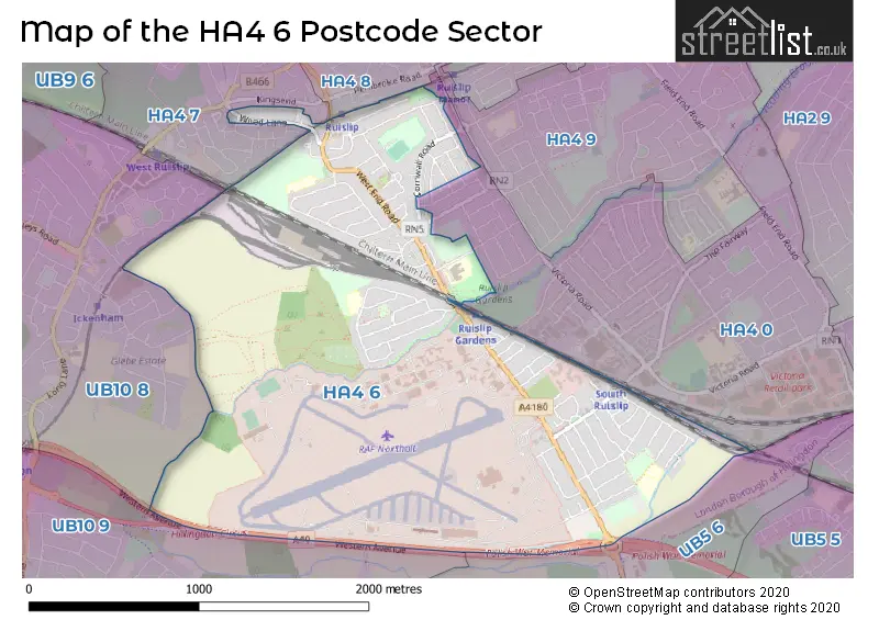
The HA4 6 Postcode shares a border with UB10 9 (UXBRIDGE ), HA4 0 (RUISLIP ), UB5 6 (NORTHOLT , RUISLIP , HAYES ), UB10 8 (ICKENHAM ), HA4 7 (RUISLIP ) and HA4 8 (RUISLIP , EASTCOTE ).
The sector is within the post town of RUISLIP.
HA4 6 is a postcode sector within the HA4 postcode district which is within the HA Harrow postcode area.
The Royal Mail delivery office for the HA4 6 postal sector is the Ruislip Delivery Office.
The area of the HA4 6 postcode sector is 2.11 square miles which is 5.47 square kilometres or 1,352.69 square acres.
Waterways within the HA4 6 postcode sector include the Yeading Brook.

Map of the HA4 6 Postcode Sector
Explore the HA4 6 postcode sector by using our free interactive map.
| H | A | 4 | - | 6 | X | X |
| H | A | 4 | Space | 6 | Letter | Letter |
Official List of Streets
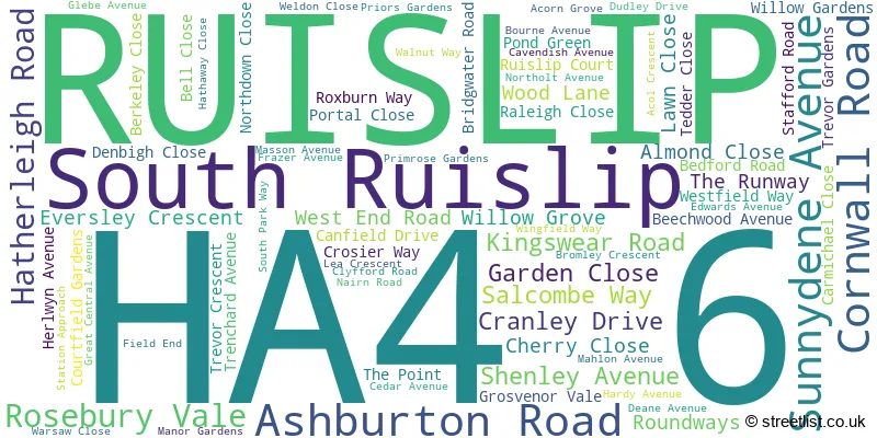
RUISLIP (74 Streets)
Unofficial Streets or Alternative Spellings
RUISLIP
CHICHESTER AVENUE LONG DRIVE SEATON GARDENS SIDMOUTH DRIVE TORRINGTON ROADNORTHOLT,
WEST END ROAD AUSTINS LANE BRIDGEWATER ROAD JIM ONEIL WALK NORTH - SOUTH LINK ROAD POLISH WAR MEMORIAL RUISLIP GARDENS STATION ROAD ST GILES AVENUEIckenham
AUSTINS LANEHillingdon
FREEZELAND WAYEaling
WESTERN AVENUEWeather Forecast for HA4 6
Press Button to Show Forecast for Northolt
| Time Period | Icon | Description | Temperature | Rain Probability | Wind |
|---|---|---|---|---|---|
| 03:00 to 06:00 | Cloudy | 5.0°C (feels like 3.0°C) | 5.00% | NE 7 mph | |
| 06:00 to 09:00 | Cloudy | 5.0°C (feels like 2.0°C) | 5.00% | NE 7 mph | |
| 09:00 to 12:00 | Cloudy | 8.0°C (feels like 6.0°C) | 5.00% | ENE 9 mph | |
| 12:00 to 15:00 | Cloudy | 11.0°C (feels like 10.0°C) | 8.00% | E 9 mph | |
| 15:00 to 18:00 | Overcast | 11.0°C (feels like 10.0°C) | 16.00% | ENE 9 mph | |
| 18:00 to 21:00 | Cloudy | 11.0°C (feels like 10.0°C) | 13.00% | NE 7 mph | |
| 21:00 to 00:00 | Cloudy | 8.0°C (feels like 5.0°C) | 12.00% | E 7 mph |
Press Button to Show Forecast for Northolt
| Time Period | Icon | Description | Temperature | Rain Probability | Wind |
|---|---|---|---|---|---|
| 00:00 to 03:00 | Cloudy | 6.0°C (feels like 4.0°C) | 17.00% | ENE 4 mph | |
| 03:00 to 06:00 | Light rain | 5.0°C (feels like 3.0°C) | 47.00% | NE 7 mph | |
| 06:00 to 09:00 | Cloudy | 6.0°C (feels like 3.0°C) | 22.00% | NE 7 mph | |
| 09:00 to 12:00 | Cloudy | 9.0°C (feels like 7.0°C) | 16.00% | ENE 9 mph | |
| 12:00 to 15:00 | Overcast | 12.0°C (feels like 10.0°C) | 17.00% | E 11 mph | |
| 15:00 to 18:00 | Overcast | 13.0°C (feels like 11.0°C) | 23.00% | ENE 13 mph | |
| 18:00 to 21:00 | Light rain | 11.0°C (feels like 9.0°C) | 53.00% | ENE 11 mph | |
| 21:00 to 00:00 | Light rain | 10.0°C (feels like 7.0°C) | 54.00% | NE 11 mph |
Press Button to Show Forecast for Northolt
| Time Period | Icon | Description | Temperature | Rain Probability | Wind |
|---|---|---|---|---|---|
| 00:00 to 03:00 | Heavy rain | 9.0°C (feels like 7.0°C) | 71.00% | NE 9 mph | |
| 03:00 to 06:00 | Heavy rain | 9.0°C (feels like 7.0°C) | 76.00% | ENE 7 mph | |
| 06:00 to 09:00 | Light rain | 9.0°C (feels like 8.0°C) | 52.00% | ESE 7 mph | |
| 09:00 to 12:00 | Heavy rain | 11.0°C (feels like 9.0°C) | 76.00% | ESE 9 mph | |
| 12:00 to 15:00 | Light rain shower (day) | 13.0°C (feels like 11.0°C) | 44.00% | SSE 11 mph | |
| 15:00 to 18:00 | Light rain shower (day) | 14.0°C (feels like 12.0°C) | 39.00% | WSW 13 mph | |
| 18:00 to 21:00 | Light rain shower (day) | 12.0°C (feels like 10.0°C) | 34.00% | WSW 11 mph | |
| 21:00 to 00:00 | Cloudy | 10.0°C (feels like 9.0°C) | 11.00% | WSW 7 mph |
Schools and Places of Education Within the HA4 6 Postcode Sector
Bourne Primary School
Community school
Cedar Avenue, Ruislip, , HA4 6UJ
Head: Ms Michelle Green
Ofsted Rating: Good
Inspection: 2022-01-12 (835 days ago)
Website: Visit Bourne Primary School Website
Phone: 01895462359
Number of Pupils: 218
Ruislip Gardens Primary School
Community school
Stafford Road, Ruislip, , HA4 6PD
Head: Miss Nicky Bulpett
Ofsted Rating: Good
Inspection: 2019-06-05 (1787 days ago)
Website: Visit Ruislip Gardens Primary School Website
Phone: 01895632895
Number of Pupils: 288
Sacred Heart Catholic Primary School
Voluntary aided school
Herlwyn Avenue, Ruislip, , HA4 6EZ
Head: Ms Theresa McManus
Ofsted Rating: Outstanding
Inspection: 2013-02-07 (4096 days ago)
Website: Visit Sacred Heart Catholic Primary School Website
Phone: 01895633240
Number of Pupils: 681
House Prices in the HA4 6 Postcode Sector
| Type of Property | 2018 Average | 2018 Sales | 2017 Average | 2017 Sales | 2016 Average | 2016 Sales | 2015 Average | 2015 Sales |
|---|---|---|---|---|---|---|---|---|
| Detached | £606,684 | 19 | £642,768 | 11 | £560,029 | 14 | £562,917 | 12 |
| Semi-Detached | £518,864 | 43 | £540,039 | 51 | £499,682 | 45 | £460,035 | 72 |
| Terraced | £490,101 | 37 | £474,406 | 39 | £469,119 | 37 | £414,755 | 55 |
| Flats | £307,289 | 49 | £338,734 | 48 | £317,004 | 65 | £283,282 | 72 |
Important Postcodes HA4 6 in the Postcode Sector
HA4 6ER is the postcode for Wood Lane Medical Centre, 2a Wood Lane
HA4 6EZ is the postcode for Sacred Heart Catholic Primary School, Herlwyn Avenue
HA4 6NG is the postcode for Royal Air Force, Northolt Airfield, West End Road
HA4 6PD is the postcode for RUISLIP GARDENS PRIMARY SCHOOL, STAFFORD ROAD
HA4 6UJ is the postcode for Bourne Primary School, Cedar Avenue
| The HA4 6 Sector is within these Local Authorities |
|
|---|---|
| The HA4 6 Sector is within these Counties |
|
| The HA4 6 Sector is within these Water Company Areas |
|