The HG5 postcode district is a postal district located in the HG Harrogate postcode area with a population of 18,703 residents according to the 2021 England and Wales Census.
The area of the HG5 postcode district is 30.23 square miles which is 78.29 square kilometres or 19,345.02 acres.
Currently, the HG5 district has about 588 postcode units spread across 3 geographic postcode sectors.
Given that each sector allows for 400 unique postcode combinations, the district has a capacity of 1,200 postcodes. With 588 postcodes already in use, this leaves 612 units available.
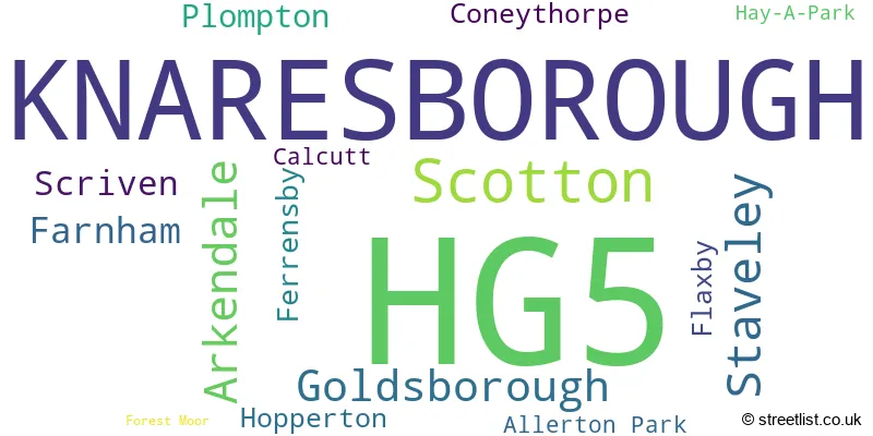
The largest settlement in the HG5 postal code is KNARESBOROUGH followed by Scotton, and Staveley.
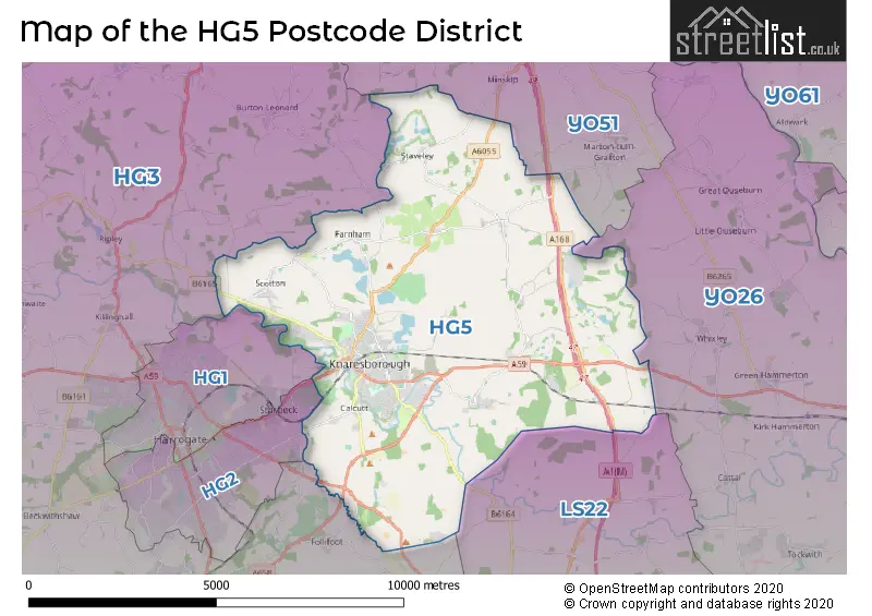
The HG5 Postcode shares a border with LS22 (WETHERBY, Collingham, Linton), HG1 (HARROGATE), HG3 (HARROGATE, Killinghall, Greenhow Hill), YO51 (Boroughbridge, Marton Cum Grafton, Roecliffe) and YO26 (YORK, Upper Poppleton, Tockwith).
In the HG5 postcode district in North Yorkshire, the primary settlement is Knaresborough. Other significant settlements include Allerton Park, Arkendale, Coneythorpe, Ferrensby, Flaxby, Hay-A-Park, Hopperton, and Staveley. The most significant post town in this district is Knaresborough.
For the district HG5, we have data on 4 postcode sectors. Here's a breakdown: The sector HG5 0, covers Knaresborough in North Yorkshire. The sector HG5 5 is non-geographic. It's often designated for PO Boxes, large organisations, or special services. The sector HG5 8, covers Knaresborough in North Yorkshire. The sector HG5 9, covers Knaresborough and Scotton and Staveley in North Yorkshire.

Map of the HG5 Postcode District
Explore the HG5 postcode district by using our free interactive map.
When it comes to local government, postal geography often disregards political borders. However, for a breakdown in the HG5 District: the district mostly encompasses the North Yorkshire area with a total of 619 postcodes.
Recent House Sales in HG5
| Date | Price | Address |
|---|---|---|
| 16/10/2023 | £350,000 | Stockwell Road, Knaresborough, HG5 0JG |
| 16/10/2023 | £155,000 | York Place, Knaresborough, HG5 0AD |
| 13/10/2023 | £492,000 | Havikil Park, Scotton, Knaresborough, HG5 9JL |
| 06/10/2023 | £165,000 | Byards Park, Knaresborough, HG5 9BB |
| 06/10/2023 | £480,000 | Scotton Drive, Knaresborough, HG5 9HG |
| 04/10/2023 | £490,000 | Pinfold Green, Staveley, Knaresborough, HG5 9LR |
| 14/09/2023 | £190,000 | Prospect Terrace, Knaresborough, HG5 0HR |
| 12/09/2023 | £425,000 | The Spinney, Knaresborough, HG5 0TD |
| 08/09/2023 | £879,950 | Forest Moor Road, Knaresborough, HG5 8LT |
| 08/09/2023 | £425,000 | Whitsundale Close, Knaresborough, HG5 0HX |
Weather Forecast for HG5
Press Button to Show Forecast for Knaresborough
| Time Period | Icon | Description | Temperature | Rain Probability | Wind |
|---|---|---|---|---|---|
| 06:00 to 09:00 | Partly cloudy (day) | 3.0°C (feels like 0.0°C) | 1.00% | N 4 mph | |
| 09:00 to 12:00 | Cloudy | 8.0°C (feels like 6.0°C) | 9.00% | NE 7 mph | |
| 12:00 to 15:00 | Overcast | 9.0°C (feels like 7.0°C) | 49.00% | ENE 9 mph | |
| 15:00 to 18:00 | Cloudy | 8.0°C (feels like 6.0°C) | 18.00% | ENE 9 mph | |
| 18:00 to 21:00 | Overcast | 8.0°C (feels like 6.0°C) | 13.00% | ENE 7 mph | |
| 21:00 to 00:00 | Cloudy | 5.0°C (feels like 3.0°C) | 7.00% | NNE 7 mph |
Press Button to Show Forecast for Knaresborough
| Time Period | Icon | Description | Temperature | Rain Probability | Wind |
|---|---|---|---|---|---|
| 00:00 to 03:00 | Cloudy | 4.0°C (feels like 1.0°C) | 4.00% | N 7 mph | |
| 03:00 to 06:00 | Cloudy | 5.0°C (feels like 1.0°C) | 10.00% | N 9 mph | |
| 06:00 to 09:00 | Light rain | 6.0°C (feels like 2.0°C) | 47.00% | N 11 mph | |
| 09:00 to 12:00 | Light rain | 7.0°C (feels like 3.0°C) | 51.00% | N 13 mph | |
| 12:00 to 15:00 | Light rain | 8.0°C (feels like 5.0°C) | 51.00% | NNW 11 mph | |
| 15:00 to 18:00 | Light rain | 10.0°C (feels like 8.0°C) | 44.00% | NW 9 mph | |
| 18:00 to 21:00 | Cloudy | 9.0°C (feels like 8.0°C) | 10.00% | WSW 7 mph | |
| 21:00 to 00:00 | Clear night | 6.0°C (feels like 4.0°C) | 2.00% | WSW 9 mph |
Press Button to Show Forecast for Knaresborough
| Time Period | Icon | Description | Temperature | Rain Probability | Wind |
|---|---|---|---|---|---|
| 00:00 to 03:00 | Clear night | 5.0°C (feels like 2.0°C) | 1.00% | SW 7 mph | |
| 03:00 to 06:00 | Clear night | 5.0°C (feels like 2.0°C) | 1.00% | SSW 7 mph | |
| 06:00 to 09:00 | Sunny day | 5.0°C (feels like 3.0°C) | 1.00% | S 7 mph | |
| 09:00 to 12:00 | Partly cloudy (day) | 10.0°C (feels like 8.0°C) | 1.00% | S 11 mph | |
| 12:00 to 15:00 | Cloudy | 13.0°C (feels like 10.0°C) | 6.00% | S 13 mph | |
| 15:00 to 18:00 | Cloudy | 14.0°C (feels like 11.0°C) | 7.00% | S 13 mph | |
| 18:00 to 21:00 | Cloudy | 13.0°C (feels like 10.0°C) | 7.00% | SSE 11 mph | |
| 21:00 to 00:00 | Partly cloudy (night) | 10.0°C (feels like 8.0°C) | 4.00% | SE 9 mph |
Press Button to Show Forecast for Knaresborough
| Time Period | Icon | Description | Temperature | Rain Probability | Wind |
|---|---|---|---|---|---|
| 00:00 to 03:00 | Clear night | 8.0°C (feels like 6.0°C) | 2.00% | SSE 9 mph | |
| 03:00 to 06:00 | Partly cloudy (night) | 6.0°C (feels like 4.0°C) | 3.00% | SE 7 mph | |
| 06:00 to 09:00 | Partly cloudy (day) | 7.0°C (feels like 5.0°C) | 3.00% | ESE 7 mph | |
| 09:00 to 12:00 | Cloudy | 11.0°C (feels like 10.0°C) | 9.00% | ESE 9 mph | |
| 12:00 to 15:00 | Cloudy | 15.0°C (feels like 13.0°C) | 12.00% | ESE 11 mph | |
| 15:00 to 18:00 | Partly cloudy (day) | 15.0°C (feels like 13.0°C) | 13.00% | ESE 11 mph | |
| 18:00 to 21:00 | Partly cloudy (day) | 13.0°C (feels like 11.0°C) | 5.00% | E 9 mph | |
| 21:00 to 00:00 | Cloudy | 10.0°C (feels like 9.0°C) | 10.00% | ENE 7 mph |
Where is the HG5 Postcode District?
The postcode district, HG5, is located in the town of Knaresborough. This town is situated near several other towns in different directions. To the South of Knaresborough is the town of Wetherby, which is approximately 6.5 miles away. To the West is Harrogate, located about 8.1 miles from Knaresborough. In the North West direction, roughly 8.8 miles away, is Ripon. Moving towards the North, we find the town of Thirsk, which is approximately 12.4 miles away. To the South East of Knaresborough is Tadcaster, located about 12.5 miles away. Lastly, in the South West direction, we have Otley, which is around 12.9 miles from Knaresborough. Additionally, Knaresborough is approximately 182.1 miles away from the center of London.
The district is within the post town of KNARESBOROUGH.
The sector has postcodes within the nation of England.
The HG5 Postcode District is in the North Yorkshire CC region of North Yorkshire within the Yorkshire and The Humber.
| Postcode Sector | Delivery Office |
|---|---|
| HG5 0 | Knaresborough Delivery Office |
| HG5 8 | Knaresborough Delivery Office |
| HG5 9 | Knaresborough Delivery Office |
| H | G | 5 | - | X | X | X |
| H | G | 5 | Space | Numeric | Letter | Letter |
Tourist Attractions within the Postcode Area
We found 1 visitor attractions within the HG5 postcode area
| Allerton Castle |
|---|
| Historic Properties |
| Historic House / House and Garden / Palace |
| View Allerton Castle on Google Maps |
Current Monthly Rental Prices
| # Bedrooms | Min Price | Max Price | Avg Price |
|---|---|---|---|
| 1 | £825 | £825 | £825 |
| 2 | £895 | £1,100 | £983 |
| 3 | £1,100 | £1,400 | £1,240 |
| 4 | £1,500 | £1,650 | £1,575 |
| 5 | £2,250 | £3,995 | £3,123 |
Current House Prices
| # Bedrooms | Min Price | Max Price | Avg Price |
|---|---|---|---|
| £200,000 | £1,400,000 | £850,000 | |
| 1 | £79,995 | £209,950 | £128,699 |
| 2 | £97,475 | £700,000 | £254,991 |
| 3 | £117,075 | £674,995 | £351,512 |
| 4 | £299,999 | £1,000,000 | £540,134 |
| 5 | £449,950 | £1,850,000 | £964,608 |
| 6 | £399,000 | £1,288,500 | £881,500 |
| 7 | £3,400,000 | £3,400,000 | £3,400,000 |
Estate Agents who Operate in the HG5 District
| Logo | Name | Brand Name | Address | Contact Number | Total Properties |
|---|---|---|---|---|---|
 | Knaresborough | Dacre Son & Hartley | 35 High Street Knaresborough HG5 0ET | 01423 227664 | 25 |
 | Knaresborough | Newby James Ltd | 15 Market Place, Knaresborough, HG5 8AL | 01423 803309 | 20 |
 | Knaresborough | Bridgfords | 35B High Street Knaresborough HG5 0ET | 01423 411225 | 12 |
 | Knaresborough | Stephensons | 85 High Street, Knaresborough, HG5 0HL | 01423 227643 | 11 |
 | Harrogate | Verity Frearson | Tudor House Albert Street, Harrogate, HG1 1JT | 01423 227834 | 8 |
| Type of Property | 2018 Average | 2018 Sales | 2017 Average | 2017 Sales | 2016 Average | 2016 Sales | 2015 Average | 2015 Sales |
|---|---|---|---|---|---|---|---|---|
| Detached | £444,679 | 120 | £471,669 | 149 | £438,722 | 121 | £417,112 | 109 |
| Semi-Detached | £274,437 | 125 | £267,804 | 93 | £269,541 | 89 | £262,542 | 99 |
| Terraced | £239,564 | 76 | £260,695 | 69 | £231,307 | 61 | £221,151 | 74 |
| Flats | £155,894 | 31 | £189,518 | 25 | £153,682 | 22 | £140,884 | 28 |