The HG5 0 postcode sector is within the county of North Yorkshire.
Did you know? According to the 2021 Census, the HG5 0 postcode sector is home to a bustling 9,663 residents!
Given that each sector allows for 400 unique postcode combinations. Letters C, I, K, M, O and V are not allowed in the last two letters of a postcode. With 270 postcodes already in use, this leaves 130 units available.
The largest settlement in the HG5 0 postal code is KNARESBOROUGH followed by Arkendale, and Allerton Park.
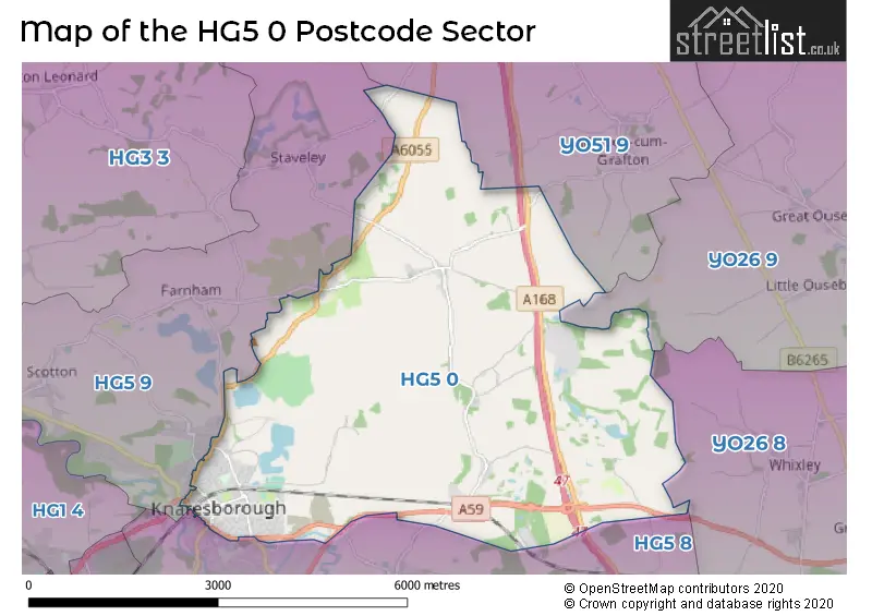
The HG5 0 Postcode shares a border with YO26 8 (Green Hammerton, Whixley, Kirk Hammerton), YO26 9 (Great Ouseburn, Little Ouseburn, Lower Dunsforth), YO51 9 (Boroughbridge, Marton Cum Grafton, Roecliffe), HG5 8 (KNARESBOROUGH, Goldsborough, Plompton) and HG5 9 (KNARESBOROUGH, Scotton, Staveley).
The sector is within the post town of KNARESBOROUGH.
HG5 0 is a postcode sector within the HG5 postcode district which is within the HG Harrogate postcode area.
The Royal Mail delivery office for the HG5 0 postal sector is the Knaresborough Delivery Office.
The area of the HG5 0 postcode sector is 13.01 square miles which is 33.69 square kilometres or 8,324.29 square acres.
The HG5 0 postcode sector is crossed by the A1M Major A road.
Waterways within the HG5 0 postcode sector include the River Nidd.

Map of the HG5 0 Postcode Sector
Explore the HG5 0 postcode sector by using our free interactive map.
| H | G | 5 | - | 0 | X | X |
| H | G | 5 | Space | 0 | Letter | Letter |
Official List of Streets
KNARESBOROUGH (160 Streets)
Ferrensby (5 Streets)
Staveley (1 Streets)
Arkendale (6 Streets)
Coneythorpe (2 Streets)
Flaxby (3 Streets)
Unofficial Streets or Alternative Spellings
Marton Cum Grafton
BRAIMBER LANEGoldsborough
STATION ROADKNARESBOROUGH
ALEXANDRA PLACE BYARDS PARK FINKLE STREET FISHER STREET GRACIOUS STREET GREENGATE LANE HAMBLETON TERRACE HAY-A-PARK LANE HILTON LANE ILES LANE KING JAMES ROAD MANSE LANE MARKET PLACE PARK GATE PARK GROVE PARK TERRACE PARK WAY PROSPECT TERRACE RAW GAP SCRIVEN ROAD SILVER STREET SLINGSBY AVENUE ST. ROBERTS CLOSE STATION ROAD STEADS YARD TENTERGATE LANE TENTERGATE ROAD VICARAGE LANE VICTORIA AVENUEStaveley
ARKENDALE ROADGreat Ouseburn
MOOR LANEFarnham
FARNHAM LANEWeather Forecast for HG5 0
Press Button to Show Forecast for Knaresborough
| Time Period | Icon | Description | Temperature | Rain Probability | Wind |
|---|---|---|---|---|---|
| 09:00 to 12:00 | Cloudy | 8.0°C (feels like 6.0°C) | 9.00% | NE 7 mph | |
| 12:00 to 15:00 | Overcast | 9.0°C (feels like 7.0°C) | 49.00% | ENE 9 mph | |
| 15:00 to 18:00 | Cloudy | 8.0°C (feels like 6.0°C) | 18.00% | ENE 9 mph | |
| 18:00 to 21:00 | Overcast | 8.0°C (feels like 6.0°C) | 13.00% | ENE 7 mph | |
| 21:00 to 00:00 | Cloudy | 5.0°C (feels like 3.0°C) | 7.00% | NNE 7 mph |
Press Button to Show Forecast for Knaresborough
| Time Period | Icon | Description | Temperature | Rain Probability | Wind |
|---|---|---|---|---|---|
| 00:00 to 03:00 | Cloudy | 4.0°C (feels like 1.0°C) | 4.00% | N 7 mph | |
| 03:00 to 06:00 | Cloudy | 5.0°C (feels like 1.0°C) | 10.00% | N 9 mph | |
| 06:00 to 09:00 | Light rain | 6.0°C (feels like 2.0°C) | 47.00% | N 11 mph | |
| 09:00 to 12:00 | Light rain | 7.0°C (feels like 3.0°C) | 51.00% | N 13 mph | |
| 12:00 to 15:00 | Light rain | 8.0°C (feels like 5.0°C) | 51.00% | NNW 11 mph | |
| 15:00 to 18:00 | Light rain | 10.0°C (feels like 8.0°C) | 44.00% | NW 9 mph | |
| 18:00 to 21:00 | Cloudy | 9.0°C (feels like 8.0°C) | 10.00% | WSW 7 mph | |
| 21:00 to 00:00 | Clear night | 6.0°C (feels like 4.0°C) | 2.00% | WSW 9 mph |
Press Button to Show Forecast for Knaresborough
| Time Period | Icon | Description | Temperature | Rain Probability | Wind |
|---|---|---|---|---|---|
| 00:00 to 03:00 | Clear night | 5.0°C (feels like 2.0°C) | 1.00% | SW 7 mph | |
| 03:00 to 06:00 | Clear night | 5.0°C (feels like 2.0°C) | 1.00% | SSW 7 mph | |
| 06:00 to 09:00 | Sunny day | 5.0°C (feels like 3.0°C) | 1.00% | S 7 mph | |
| 09:00 to 12:00 | Partly cloudy (day) | 10.0°C (feels like 8.0°C) | 1.00% | S 11 mph | |
| 12:00 to 15:00 | Cloudy | 13.0°C (feels like 10.0°C) | 6.00% | S 13 mph | |
| 15:00 to 18:00 | Cloudy | 14.0°C (feels like 11.0°C) | 7.00% | S 13 mph | |
| 18:00 to 21:00 | Cloudy | 13.0°C (feels like 10.0°C) | 7.00% | SSE 11 mph | |
| 21:00 to 00:00 | Partly cloudy (night) | 10.0°C (feels like 8.0°C) | 4.00% | SE 9 mph |
Press Button to Show Forecast for Knaresborough
| Time Period | Icon | Description | Temperature | Rain Probability | Wind |
|---|---|---|---|---|---|
| 00:00 to 03:00 | Clear night | 8.0°C (feels like 6.0°C) | 2.00% | SSE 9 mph | |
| 03:00 to 06:00 | Partly cloudy (night) | 6.0°C (feels like 4.0°C) | 3.00% | SE 7 mph | |
| 06:00 to 09:00 | Partly cloudy (day) | 7.0°C (feels like 5.0°C) | 3.00% | ESE 7 mph | |
| 09:00 to 12:00 | Cloudy | 11.0°C (feels like 10.0°C) | 9.00% | ESE 9 mph | |
| 12:00 to 15:00 | Cloudy | 15.0°C (feels like 13.0°C) | 12.00% | ESE 11 mph | |
| 15:00 to 18:00 | Partly cloudy (day) | 15.0°C (feels like 13.0°C) | 13.00% | ESE 11 mph | |
| 18:00 to 21:00 | Partly cloudy (day) | 13.0°C (feels like 11.0°C) | 5.00% | E 9 mph | |
| 21:00 to 00:00 | Cloudy | 10.0°C (feels like 9.0°C) | 10.00% | ENE 7 mph |
Schools and Places of Education Within the HG5 0 Postcode Sector
The Forest School
Academy special converter
Park Lane, Knaresborough, North Yorkshire, HG5 0DQ
Head: Mrs Shona Crichton
Ofsted Rating: Requires improvement
Inspection: 2023-02-22 (430 days ago)
Website: Visit The Forest School Website
Phone: 01423864583
Number of Pupils: 136
House Prices in the HG5 0 Postcode Sector
| Type of Property | 2018 Average | 2018 Sales | 2017 Average | 2017 Sales | 2016 Average | 2016 Sales | 2015 Average | 2015 Sales |
|---|---|---|---|---|---|---|---|---|
| Detached | £401,713 | 65 | £432,373 | 68 | £354,594 | 44 | £334,425 | 32 |
| Semi-Detached | £243,668 | 80 | £234,447 | 60 | £240,751 | 49 | £207,948 | 50 |
| Terraced | £237,541 | 46 | £249,507 | 35 | £207,808 | 35 | £198,436 | 41 |
| Flats | £142,482 | 14 | £142,786 | 7 | £140,227 | 11 | £141,480 | 10 |
Important Postcodes HG5 0 in the Postcode Sector
HG5 0AD is the postcode for Doctors Surgery, 31b York Place
HG5 0BN is the postcode for CHILDRENS CENTRE INC SOCIAL CARE OFFICES, Knaresborough Childrens Centre, Manor Road, and KNARESBOROUGH CHILDRENS CENTRE AND CARE OFFICES, MANOR ROAD, KNARESBOROUGH
HG5 0DG is the postcode for MAIN BUILDING, The Forest School, Park Lane,
HG5 0DQ is the postcode for TOP BLOCK, The Forest School, Park Lane, MAIN BUILDING, The Forest School, Park Lane, and The Forest School, Park Lane
HG5 0HL is the postcode for Knaresborough House, High Street
HG5 0HW is the postcode for Knaresborough Town Council, Knaresborough House, High Street
HG5 0JN is the postcode for KNARESBOROUGH ST JOHNS CHURCH OF ENGLAND PRIMARY SCHOOL, STOCKWELL ROAD, KNARESBOROUGH, and St. Johns C of E Primary School, Stockwell Road
HG5 0JY is the postcode for Doctors Surgery, 21 Stockwell Road
HG5 0LG is the postcode for Knaresborough Community Centre, Stockwell Avenue
HG5 0SL is the postcode for MAIN BUILDING, Meadowside Cp School, Halfpenny Lane, and Meadowside Cp School, Halfpenny Lane
HG5 0UB is the postcode for Alexander House, 3 Ash Tree Road, Beech House Surgery, 1 Ash Tree Road, and Craven Harrogate & Rural District Pct, Alexander House, Ash Tree Road
| The HG5 0 Sector is within these Local Authorities |
|
|---|---|
| The HG5 0 Sector is within these Counties |
|
| The HG5 0 Sector is within these Water Company Areas |
|
Tourist Attractions within the HG5 0 Postcode Area
We found 1 visitor attractions within the HG5 postcode area
| Allerton Castle |
|---|
| Historic Properties |
| Historic House / House and Garden / Palace |
| View Allerton Castle on Google Maps |