The HP3 9 postcode sector is within the county of Hertfordshire.
Did you know? According to the 2021 Census, the HP3 9 postcode sector is home to a bustling 15,668 residents!
Given that each sector allows for 400 unique postcode combinations. Letters C, I, K, M, O and V are not allowed in the last two letters of a postcode. With 318 postcodes already in use, this leaves 82 units available.
The largest settlement in the HP3 9 postal code is HEMEL HEMPSTEAD followed by Nash Mills Wharf, and APSLEY.
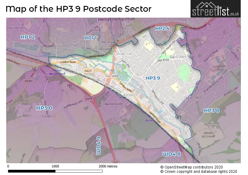
The HP3 9 Postcode shares a border with HP1 2 (HEMEL HEMPSTEAD), HP2 4 (HEMEL HEMPSTEAD, Paradise Industrial Estate), HP3 0 (BOVINGDON, HEMEL HEMPSTEAD, Felden), WD4 8 (KINGS LANGLEY , HUNTON BRIDGE , ABBOTS LANGLEY ), HP1 1 (HEMEL HEMPSTEAD) and HP3 8 (HEMEL HEMPSTEAD, NASH MILLS, Pimlico).
The sector is within the post town of HEMEL HEMPSTEAD.
HP3 9 is a postcode sector within the HP1 postcode district which is within the HP Hemel Hempstead postcode area.
The Royal Mail delivery office for the HP3 9 postal sector is the unknown.
The area of the HP3 9 postcode sector is 1.40 square miles which is 3.62 square kilometres or 894.00 square acres.
Waterways within the HP3 9 postcode sector include the River Gade, Grand Union Canal.

Map of the HP3 9 Postcode Sector
Explore the HP3 9 postcode sector by using our free interactive map.
| H | P | 3 | - | 9 | X | X |
| H | P | 3 | Space | 9 | Letter | Letter |
Official List of Streets
HEMEL HEMPSTEAD (154 Streets)
Nash Mills Wharf (5 Streets)
Shendish (1 Streets)
Unofficial Streets or Alternative Spellings
HEMEL HEMPSTEAD
BARNACRES ROAD BELSIZE ROAD BENNETTS END CLOSE BENNETTS END ROAD BENNETTS GATE CHIPPERFIELD ROAD FISHERY ROAD GATE CROFT HEATH LANE KIMPS WAY KING EDWARD STREET MILL CLOSE PINECROFT STATION ROAD THE DENES BRUNEL COURT CAVENDISH COURT CHARLOTTE COURT GRAND UNION CANAL HOLLY BANK KINGS COURT LOCKVIEW COURT NASH MILLS LANE ORAM PLACE PARTRIDGES PINEWOOD GARDENS PRINCESS COURT SAINT ALBANS HILL SAINT ALBANS ROAD SHELLEY MEWS ST ALBANS ROAD ST JOHNS ROAD THE CART TRACK THE NAP THE PLOUGH ROUNDABOUT TWO WATERS WAY WOODMAN ROADFelden
FEATHERBED LANEPimlico
BUNKERS LANENash Mills
LOWER ROADParadise Industrial Estate
WOOD LANESchools and Places of Education Within the HP3 9 Postcode Sector
Belswains Primary School
Community school
Barnfield, Hemel Hempstead, Hertfordshire, HP3 9QJ
Head: Mrs Neysa Claridge
Ofsted Rating: Good
Inspection: 2023-03-29 (421 days ago)
Website: Visit Belswains Primary School Website
Phone: 01442264324
Number of Pupils: 377
Lime Walk Primary School
Community school
Lime Walk, Hemel Hempstead, Hertfordshire, HP3 9LN
Head: Mr Andrew Kerse
Ofsted Rating: Good
Inspection: 2023-02-08 (470 days ago)
Website: Visit Lime Walk Primary School Website
Phone: 01442262341
Number of Pupils: 204
Nash Mills Church of England Primary School
Voluntary aided school
Belswains Lane, Hemel Hempstead, Hertfordshire, HP3 9XB
Head: Mr Allan Maher
Ofsted Rating: Good
Inspection: 2022-11-24 (546 days ago)
Website: Visit Nash Mills Church of England Primary School Website
Phone: 01442252972
Number of Pupils: 230
Tudor Primary School
Community school
Redwood Drive, Hemel Hempstead, Hertfordshire, HP3 9ER
Head: Mr Rob Weightman
Ofsted Rating: Good
Inspection: 2022-12-07 (533 days ago)
Website: Visit Tudor Primary School Website
Phone: 01442256294
Number of Pupils: 434
House Prices in the HP3 9 Postcode Sector
| Type of Property | 2018 Average | 2018 Sales | 2017 Average | 2017 Sales | 2016 Average | 2016 Sales | 2015 Average | 2015 Sales |
|---|---|---|---|---|---|---|---|---|
| Detached | £485,342 | 19 | £527,140 | 15 | £477,026 | 19 | £431,690 | 21 |
| Semi-Detached | £412,557 | 57 | £390,156 | 76 | £381,935 | 53 | £338,875 | 74 |
| Terraced | £368,006 | 84 | £366,979 | 83 | £361,165 | 82 | £312,537 | 100 |
| Flats | £269,822 | 107 | £283,699 | 145 | £272,876 | 235 | £251,332 | 237 |
Important Postcodes HP3 9 in the Postcode Sector
HP3 9BF is the postcode for Network House, Brindley Way, Apsley One, Brindley Way, and Meadowside House, Brindley Way
HP3 9ER is the postcode for MAIN BLOCK, Tudor Primary School, Redwood Drive, Tudor School, Redwood Drive, TUDOR PRIMARY SCHOOL, REDWOOD DRIVE, HEMEL HEMPSTEAD, and NEW BLOCK, Tudor School, Redwood Drive
HP3 9JW is the postcode for The Orchards, Ashley Close
HP3 9LN is the postcode for Lime Walk Primary School, Lime Walk, and LIME WALK PRIMARY SCHOOL, LIME WALK, HEMEL HEMPSTEAD
HP3 9LY is the postcode for Bennetts End Surgery, Gatecroft
HP3 9QJ is the postcode for BLOCK B BELSWAINS SCHOOL, Belswains Primary School, Barnfield, Belswains Infant School, Barnfield, and Belswains Primary School, Barnfield
HP3 9XB is the postcode for Nash Mills C of E Primary School, Belswains Lane
| The HP3 9 Sector is within these Local Authorities |
|
|---|---|
| The HP3 9 Sector is within these Counties |
|
| The HP3 9 Sector is within these Water Company Areas |
|