The HR7 postcode district is a postal district located in the HR Hereford postcode area with a population of 7,357 residents according to the 2021 England and Wales Census.
The area of the HR7 postcode district is 47.99 square miles which is 124.29 square kilometres or 30,712.01 acres.
Currently, the HR7 district has about 278 postcode units spread across 1 geographic postcode sectors.
Given that each sector allows for 400 unique postcode combinations, the district has a capacity of 400 postcodes. With 278 postcodes already in use, this leaves 122 units available.
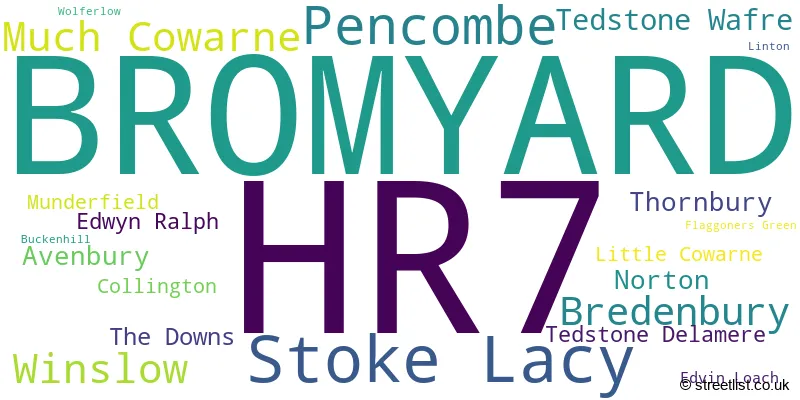
The largest settlement in the HR7 postal code is BROMYARD followed by Tedstone Wafre, and Stoke Lacy.
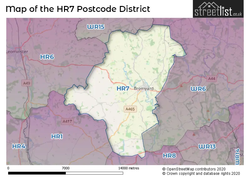
The HR7 Postcode shares a border with HR8 (LEDBURY, Much Marcle, Bosbury), WR6 (Martley, Clifton-on-Teme, Holt Heath), WR15 (TENBURY WELLS, Burford, Newnham Bridge), HR1 (HEREFORD, Bartestree, Bodenham) and HR6 (LEOMINSTER, Kingsland, Pembridge).
The HR7 postcode district in Herefordshire, England, is primarily represented by the settlement of Bromyard. Other significant settlements in this district include Avenbury, Bredenbury, Collington, Edvin Loach, Edwyn Ralph, Little Cowarne, Much Cowarne, Munderfield, Norton, Pencombe, Stoke Lacy, Tedstone Delamere, Tedstone Wafre, The Downs, Thornbury, Winslow, and Wolferlow.
For the district HR7, we have data on 1 postcode sectors. Here's a breakdown: The sector HR7 4, covers Bromyard in Herefordshire.
HR7 Postcode Sectors

Map of the HR7 Postcode District
Explore the HR7 postcode district by using our free interactive map.
When it comes to local government, postal geography often disregards political borders. However, for a breakdown in the HR7 District: the district mostly encompasses the County of Herefordshire (276 postcodes), and finally, the Malvern Hills District area (4 postcodes).
Recent House Sales in HR7
| Date | Price | Address |
|---|---|---|
| 30/08/2023 | £292,500 | Bramley Orchards, Bromyard, HR7 4UT |
| 30/08/2023 | £217,500 | Old Road, Bromyard, HR7 4BQ |
| 23/08/2023 | £125,000 | Flaggoners Close, Bromyard, HR7 4TZ |
| 21/08/2023 | £210,000 | Winslow Road, Bromyard, HR7 4TX |
| 15/08/2023 | £190,000 | Old Ditch Close, Bromyard, HR7 4DE |
| 14/08/2023 | £210,000 | Porthouse Rise, Bromyard, HR7 4FS |
| 11/08/2023 | £495,000 | Lower Hardwick Lane, Winslow, Bromyard, HR7 4LN |
| 11/08/2023 | £173,000 | St Peters Gardens, Bromyard, HR7 4DA |
| 04/08/2023 | £284,000 | Porthouse Rise, Bromyard, HR7 4FS |
| 31/07/2023 | £155,000 | Rowberry Street, Bromyard, HR7 4DU |
Weather Forecast for HR7
Press Button to Show Forecast for Bromyard
| Time Period | Icon | Description | Temperature | Rain Probability | Wind |
|---|---|---|---|---|---|
| 03:00 to 06:00 | Cloudy | 4.0°C (feels like 2.0°C) | 6.00% | ENE 4 mph | |
| 06:00 to 09:00 | Cloudy | 4.0°C (feels like 1.0°C) | 6.00% | ENE 7 mph | |
| 09:00 to 12:00 | Cloudy | 6.0°C (feels like 4.0°C) | 7.00% | E 7 mph | |
| 12:00 to 15:00 | Cloudy | 8.0°C (feels like 7.0°C) | 12.00% | ENE 7 mph | |
| 15:00 to 18:00 | Cloudy | 9.0°C (feels like 8.0°C) | 13.00% | ENE 4 mph | |
| 18:00 to 21:00 | Cloudy | 8.0°C (feels like 7.0°C) | 10.00% | E 4 mph | |
| 21:00 to 00:00 | Partly cloudy (night) | 5.0°C (feels like 4.0°C) | 9.00% | NE 4 mph |
Press Button to Show Forecast for Bromyard
| Time Period | Icon | Description | Temperature | Rain Probability | Wind |
|---|---|---|---|---|---|
| 00:00 to 03:00 | Cloudy | 4.0°C (feels like 1.0°C) | 13.00% | ENE 7 mph | |
| 03:00 to 06:00 | Cloudy | 3.0°C (feels like 0.0°C) | 13.00% | NE 7 mph | |
| 06:00 to 09:00 | Cloudy | 3.0°C (feels like 0.0°C) | 12.00% | NE 7 mph | |
| 09:00 to 12:00 | Cloudy | 7.0°C (feels like 4.0°C) | 16.00% | ENE 9 mph | |
| 12:00 to 15:00 | Light rain | 9.0°C (feels like 7.0°C) | 49.00% | ENE 9 mph | |
| 15:00 to 18:00 | Overcast | 10.0°C (feels like 8.0°C) | 22.00% | ENE 9 mph | |
| 18:00 to 21:00 | Cloudy | 9.0°C (feels like 7.0°C) | 19.00% | NE 9 mph | |
| 21:00 to 00:00 | Cloudy | 7.0°C (feels like 4.0°C) | 21.00% | NE 11 mph |
Press Button to Show Forecast for Bromyard
| Time Period | Icon | Description | Temperature | Rain Probability | Wind |
|---|---|---|---|---|---|
| 00:00 to 03:00 | Light rain | 6.0°C (feels like 3.0°C) | 50.00% | NE 11 mph | |
| 03:00 to 06:00 | Heavy rain | 6.0°C (feels like 2.0°C) | 73.00% | NNE 11 mph | |
| 06:00 to 09:00 | Heavy rain | 6.0°C (feels like 2.0°C) | 75.00% | NNE 13 mph | |
| 09:00 to 12:00 | Light rain | 7.0°C (feels like 3.0°C) | 55.00% | N 13 mph | |
| 12:00 to 15:00 | Light rain | 9.0°C (feels like 5.0°C) | 53.00% | NNW 13 mph | |
| 15:00 to 18:00 | Light rain | 10.0°C (feels like 7.0°C) | 51.00% | NNW 13 mph | |
| 18:00 to 21:00 | Light rain shower (day) | 9.0°C (feels like 8.0°C) | 34.00% | NNW 7 mph | |
| 21:00 to 00:00 | Clear night | 6.0°C (feels like 5.0°C) | 6.00% | W 4 mph |
Where is the HR7 Postcode District?
The data shows that the postcode district HR7 is located in Bromyard, a town in Herefordshire. Bromyard is surrounded by several nearby towns, including Tenbury Wells to the north (8.7 miles away), Leominster to the west (8.8 miles away), Malvern to the southeast (10.9 miles away), Ledbury to the south (11.8 miles away), Worcester to the east (13.8 miles away), Hereford to the southwest (14.1 miles away), Ludlow to the northwest (14.7 miles away), and Stourport-on-Severn to the northeast (15.2 miles away). Furthermore, the distance to London from Bromyard is approximately 113.5 miles.
The district is within the post town of BROMYARD.
The sector has postcodes within the nation of England.
The HR7 Postcode District is covers the following regions.
- Herefordshire, County of - Herefordshire, Worcestershire and Warwickshire - West Midlands (England)
- Worcestershire - Herefordshire, Worcestershire and Warwickshire - West Midlands (England)
Postcode Sectors within the HR7 District
| Postcode Sector | Delivery Office |
|---|---|
| HR7 4 | Bromyard Postal Delivery Office |
| H | R | 7 | - | X | X | X |
| H | R | 7 | Space | Numeric | Letter | Letter |
Current Monthly Rental Prices
| # Bedrooms | Min Price | Max Price | Avg Price |
|---|
Current House Prices
| # Bedrooms | Min Price | Max Price | Avg Price |
|---|---|---|---|
| £175,000 | £1,995,000 | £1,085,000 | |
| 1 | £65,000 | £190,000 | £108,600 |
| 2 | £65,000 | £505,995 | £203,207 |
| 3 | £75,000 | £825,000 | £360,559 |
| 4 | £260,000 | £645,000 | £422,330 |
| 5 | £395,000 | £1,950,000 | £916,875 |
| 6 | £595,000 | £1,300,000 | £930,000 |
| 7 | £1,200,000 | £1,200,000 | £1,200,000 |
Estate Agents who Operate in the HR7 District
| Logo | Name | Brand Name | Address | Contact Number | Total Properties |
|---|---|---|---|---|---|
 | Bromyard | Barry Bufton | 27 High Street, Bromyard, HR7 4AA | 01885 477134 | 17 |
 | Bromyard | Flint & Cook | 37 High Street Bromyard HR7 4AE | 01885 477330 | 12 |
 | Hereford | Andrew Morris Estate Agents Limited | 1 Bridge Street, Hereford, HR4 9DF | 01432 805202 | 7 |
 | Wiltshire | Quickmove Properties | 15 Interface Business Park, Binknoll Lane, Royal Wootton Bassett, SN4 8SY | 01793 540551 | 6 |
 | Covering the West Midlands | Andrew Grant | Covering the West Midlands | 01905 673182 | 6 |
| Type of Property | 2018 Average | 2018 Sales | 2017 Average | 2017 Sales | 2016 Average | 2016 Sales | 2015 Average | 2015 Sales |
|---|---|---|---|---|---|---|---|---|
| Detached | £322,203 | 37 | £305,937 | 51 | £275,451 | 62 | £307,083 | 47 |
| Semi-Detached | £206,800 | 25 | £190,532 | 30 | £192,677 | 28 | £187,659 | 22 |
| Terraced | £169,161 | 28 | £152,242 | 30 | £176,662 | 26 | £154,700 | 27 |
| Flats | £86,107 | 7 | £99,242 | 6 | £74,439 | 9 | £80,983 | 9 |