
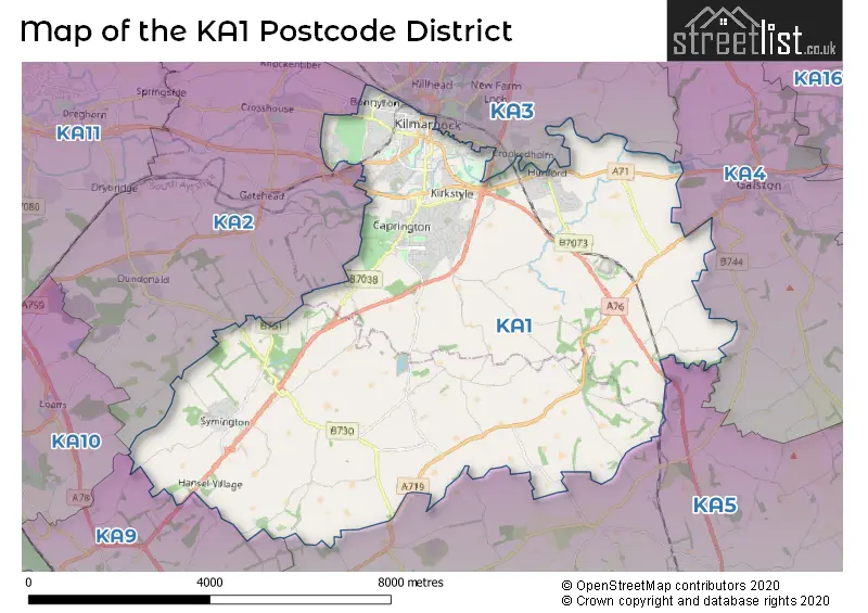
Map of the Postcode District
Explore the postcode district by using our interactive map.
Circles represent recorded crime; the larger the circle, the higher the crime rates.
Your support helps keep this site running!
If you enjoy using this website, consider buying me a coffee to help cover hosting costs.
The postcode district located in the KA Kilmarnock postal area , KA1 has a population of 29,225 residents according to the 2011 Scotland Census.
The area of the district is 29.22 square miles (75.67 square kilometers or 18,699.09 acres).
Where is the KA1 District?
To give you an idea where the district is located we have created the following table showing nearby towns.
Nearest Towns to KA1
| Town | Distance (miles) | Direction |
|---|---|---|
| Galston | 4.74 | ENE |
| Prestwick | 6.85 | SW |
| Newmilns | 6.92 | ENE |
| Troon | 7.16 | WSW |
| Irvine | 7.71 | WNW |
| Stewarton | 7.90 | N |
| Darvel | 8.55 | ENE |
| Ayr | 9.45 | SW |
| Kilwinning | 10.11 | NW |
| Cumnock | 11.65 | SE |
| Stevenston | 11.72 | WNW |
| Saltcoats | 12.65 | WNW |
| Ardrossan | 13.78 | WNW |
| Barrhead | 16.52 | NNE |
| Maybole | 16.65 | SSW |
| New Cumnock | 16.80 | SE |
| East Kilbride | 18.15 | NE |
| Johnstone | 18.61 | N |
| Paisley | 19.28 | N |
Post towns for this district are DARVEL, KILMARNOCK.
Postcode Information for District KA1 (Total Geographical Postcodes: 982)
| Location | Post Town | Sector | Number of Postcodes |
|---|---|---|---|
| KILMARNOCK | KILMARNOCK | KA1 3 | 216 |
| KILMARNOCK | KILMARNOCK | KA1 2 | 203 |
| KILMARNOCK | KILMARNOCK | KA1 4 | 196 |
| KILMARNOCK | KILMARNOCK | KA1 1 | 137 |
| Hurlford | KILMARNOCK | KA1 5 | 108 |
| Symington | KILMARNOCK | KA1 5 | 68 |
| KILMARNOCK | KILMARNOCK | KA1 5 | 19 |
| Craigie | KILMARNOCK | KA1 5 | 19 |
| Annandale | KILMARNOCK | KA1 2 | 7 |
| Glencairn Industrial Estate | KILMARNOCK | KA1 4 | 6 |
| Loreny Industrial Estate | KILMARNOCK | KA1 5 | 2 |
| Caprington | KILMARNOCK | KA1 4 | 1 |
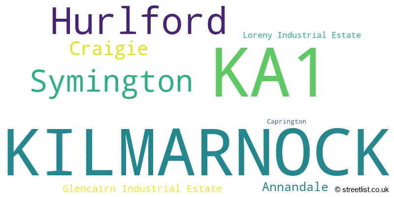
The primary settlement in the KA1 postcode district is Kilmarnock, which belongs to the county of Ayrshire and Arran. Other significant settlements in the district include Annandale, Caprington, Glencairn Industrial Estate, Craigie, Hurlford, Loreny Industrial Estate, and Symington. The main post town in the district is also Kilmarnock.
When it comes to local government, postal geography often disregards political borders. However, this district intersects the following councils: the district mostly encompasses the East Ayrshire (930 postal codes), and finally, the South Ayrshire area (91 postal codes).
The largest settlement in the KA1 postal code is KILMARNOCK followed by Hurlford, and Symington.
The KA1 Postcode shares a border with KA2 (Dundonald, Crosshouse, KILMARNOCK), KA9 (PRESTWICK, Monkton), KA3 (KILMARNOCK, Stewarton, Kilmaurs), KA4 (GALSTON, Moscow) and KA5 (MAUCHLINE, Catrine, Tarbolton).


Stations in the Sector
Kilmarnock
CRS Code: KMK
Operator: SR
Line: Glasgow South Western Line
Company: ScotRail
Accessable Motorway Junctions
M77 J8
Average Driving Time from within the district: 6.92
Average Driving Distance: 5.31
Number of Postcodes that can access the Motorway Junction: 1009
M77 J7
Average Driving Time from within the district: 8.18
Average Driving Distance: 6.34
Number of Postcodes that can access the Motorway Junction: 1009
M77 J6
Average Driving Time from within the district: 11.15
Average Driving Distance: 9.00
Number of Postcodes that can access the Motorway Junction: 1009
M77 J5
Average Driving Time from within the district: 15.35
Average Driving Distance: 14.03
Number of Postcodes that can access the Motorway Junction: 1009
M77 J4
Average Driving Time from within the district: 17.72
Average Driving Distance: 16.11
Number of Postcodes that can access the Motorway Junction: 1009
Weather Forecast for Craigie
| Time Period | Icon | Description | Temperature | Rain Probability | Wind |
|---|---|---|---|---|---|
| 12:00 to 15:00 | Light rain shower (day) | 11.0°C (feels like 8.0°C) | 38.00% | WSW 16 mph | |
| 15:00 to 18:00 | Partly cloudy (day) | 11.0°C (feels like 9.0°C) | 37.00% | WSW 11 mph | |
| 18:00 to 21:00 | Partly cloudy (night) | 10.0°C (feels like 8.0°C) | 1.00% | SSW 9 mph | |
| 21:00 to 00:00 | Cloudy | 10.0°C (feels like 7.0°C) | 4.00% | SSW 11 mph |
| Time Period | Icon | Description | Temperature | Rain Probability | Wind |
|---|---|---|---|---|---|
| 00:00 to 03:00 | Cloudy | 10.0°C (feels like 7.0°C) | 4.00% | SSW 13 mph | |
| 03:00 to 06:00 | Cloudy | 10.0°C (feels like 7.0°C) | 12.00% | SSW 16 mph | |
| 06:00 to 09:00 | Cloudy | 10.0°C (feels like 7.0°C) | 18.00% | SSW 13 mph | |
| 09:00 to 12:00 | Partly cloudy (day) | 11.0°C (feels like 8.0°C) | 1.00% | SSW 13 mph | |
| 12:00 to 15:00 | Cloudy | 13.0°C (feels like 11.0°C) | 3.00% | SSW 16 mph | |
| 15:00 to 18:00 | Cloudy | 13.0°C (feels like 10.0°C) | 4.00% | S 13 mph | |
| 18:00 to 21:00 | Cloudy | 11.0°C (feels like 9.0°C) | 4.00% | S 11 mph | |
| 21:00 to 00:00 | Cloudy | 12.0°C (feels like 9.0°C) | 5.00% | S 16 mph |
| Time Period | Icon | Description | Temperature | Rain Probability | Wind |
|---|---|---|---|---|---|
| 00:00 to 03:00 | Cloudy | 13.0°C (feels like 9.0°C) | 14.00% | S 18 mph | |
| 03:00 to 06:00 | Cloudy | 12.0°C (feels like 9.0°C) | 5.00% | S 16 mph | |
| 06:00 to 09:00 | Cloudy | 12.0°C (feels like 9.0°C) | 4.00% | S 16 mph | |
| 09:00 to 12:00 | Cloudy | 12.0°C (feels like 9.0°C) | 5.00% | SSE 16 mph | |
| 12:00 to 15:00 | Overcast | 13.0°C (feels like 10.0°C) | 10.00% | SSE 18 mph | |
| 15:00 to 18:00 | Overcast | 13.0°C (feels like 10.0°C) | 14.00% | SSE 16 mph | |
| 18:00 to 21:00 | Overcast | 13.0°C (feels like 10.0°C) | 24.00% | S 13 mph | |
| 21:00 to 00:00 | Light rain | 13.0°C (feels like 11.0°C) | 55.00% | S 11 mph |
| Time Period | Icon | Description | Temperature | Rain Probability | Wind |
|---|---|---|---|---|---|
| 00:00 to 03:00 | Light rain | 12.0°C (feels like 10.0°C) | 53.00% | S 11 mph | |
| 03:00 to 06:00 | Light rain | 11.0°C (feels like 9.0°C) | 50.00% | W 9 mph | |
| 06:00 to 09:00 | Light rain | 10.0°C (feels like 8.0°C) | 53.00% | WNW 9 mph | |
| 09:00 to 12:00 | Light rain shower (day) | 10.0°C (feels like 8.0°C) | 42.00% | SSE 9 mph | |
| 12:00 to 15:00 | Heavy rain shower (day) | 11.0°C (feels like 9.0°C) | 59.00% | N 11 mph | |
| 15:00 to 18:00 | Light rain shower (day) | 11.0°C (feels like 10.0°C) | 43.00% | NNE 9 mph | |
| 18:00 to 21:00 | Partly cloudy (night) | 9.0°C (feels like 7.0°C) | 12.00% | N 9 mph | |
| 21:00 to 00:00 | Partly cloudy (night) | 8.0°C (feels like 6.0°C) | 7.00% | SW 7 mph |
| Time Period | Icon | Description | Temperature | Rain Probability | Wind |
|---|---|---|---|---|---|
| 00:00 to 03:00 | Cloudy | 8.0°C (feels like 6.0°C) | 15.00% | S 7 mph | |
| 03:00 to 06:00 | Cloudy | 8.0°C (feels like 6.0°C) | 25.00% | SSW 9 mph | |
| 06:00 to 09:00 | Overcast | 9.0°C (feels like 7.0°C) | 32.00% | SW 11 mph | |
| 09:00 to 12:00 | Light rain | 10.0°C (feels like 7.0°C) | 59.00% | SW 11 mph | |
| 12:00 to 15:00 | Light rain | 11.0°C (feels like 8.0°C) | 53.00% | SW 13 mph | |
| 15:00 to 18:00 | Light rain shower (day) | 10.0°C (feels like 7.0°C) | 42.00% | WSW 16 mph | |
| 18:00 to 21:00 | Light rain shower (night) | 9.0°C (feels like 7.0°C) | 38.00% | WSW 13 mph | |
| 21:00 to 00:00 | Light rain shower (night) | 9.0°C (feels like 6.0°C) | 37.00% | WSW 13 mph |
| Postal Sector | Delivery Office |
|---|---|
| KA1 1 | Kilmarnock Delivery Office |
| KA1 2 | Kilmarnock Delivery Office |
| KA1 3 | Kilmarnock Delivery Office |
| KA1 4 | Kilmarnock Delivery Office |
| KA1 5 | Kilmarnock Delivery Office |
| K | A | 1 | - | X | X | X |
| K | A | 1 | Space | Numeric | Letter | Letter |
Street List for the KA1 District
Current Monthly Rental Prices
| # Bedrooms | Min Price | Max Price | Avg Price |
|---|---|---|---|
| 1 | £450 | £525 | £475 |
| 2 | £450 | £650 | £554 |
| 3 | £795 | £795 | £795 |
Current House Prices
| # Bedrooms | Min Price | Max Price | Avg Price |
|---|---|---|---|
| £50,000 | £100,000 | £75,000 | |
| 1 | £39,995 | £55,000 | £48,641 |
| 2 | £37,500 | £225,000 | £97,021 |
| 3 | £85,000 | £275,000 | £176,887 |
| 4 | £59,000 | £330,000 | £256,298 |
| 5 | £330,000 | £685,000 | £497,857 |
| 8 | £925,000 | £925,000 | £925,000 |
Estate Agents
| Logo | Name | Brand Name | Address | Contact Number |
|---|---|---|---|---|
 | Fardalehill | Bellway Homes (Scotland West) | Kilmarnock, KA1 2LA | 01563 597207 |
 | Kilmarnock | Property Matters Ltd | 97 John Finnie Street, Kilmarnock, KA1 1BG | 01563 590802 |
 | Newmilns | Greig Residential | 18 Henrietta Street Galston KA4 8HQ | 01563 501350 |
 | Kilmarnock | Slater Hogg & Howison | 31-33 John Finnie Street Kilmarnock KA1 1BL | 01563 593216 |
 | Troon | JC Roxburgh Properties Ltd. | 19 -21 Ayr Street, Troon, KA10 6EB | 01292 431498 |