The KA2 postcode district is a postal district located in the KA Kilmarnock postcode area with a population of 7,144 residents according to the 2011 Scotland Census.
The area of the KA2 postcode district is 14.43 square miles which is 37.37 square kilometres or 9,233.73 acres.
Currently, the KA2 district has about 225 postcode units spread across 18 geographic postcode sectors.
Given that each sector allows for 400 unique postcode combinations, the district has a capacity of 7,200 postcodes. With 225 postcodes already in use, this leaves 6975 units available.
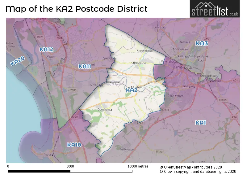
The largest settlement in the KA2 postal code is Dundonald followed by Crosshouse, and KILMARNOCK.
The KA2 Postcode shares a border with KA11 (Dreghorn, Girdle Toll, IRVINE) and KA1 (KILMARNOCK, Hurlford, Symington).
The primary settlement in the KA2 postcode district is Kilmarnock in the county of Ayrshire and Arran. Other significant settlements include Crosshouse, Gatehead, Knockentiber, Dundonald, and Symington. Kilmarnock is the most significant post town in this district.
For the district KA2, we have data on 2 postcode sectors. Here's a breakdown: The sector KA2 0, covers Crosshouse and Kilmarnock and Knockentiber in Ayrshire and Arran. The sector KA2 9, covers Dundonald in Ayrshire and Arran.

Map of the KA2 Postcode District
Explore the KA2 postcode district by using our free interactive map.
When it comes to local government, postal geography often disregards political borders. However, for a breakdown in the KA2 District: the district mostly encompasses the East Ayrshire (122 postcodes), followed by the South Ayrshire area (101 postcodes), and finally, the North Ayrshire area (4 postcodes).
Weather Forecast for KA2
Press Button to Show Forecast for Kilmarnock F.C.
| Time Period | Icon | Description | Temperature | Rain Probability | Wind |
|---|---|---|---|---|---|
| 00:00 to 03:00 | Cloudy | 4.0°C (feels like 2.0°C) | 4.00% | E 4 mph | |
| 03:00 to 06:00 | Cloudy | 3.0°C (feels like 1.0°C) | 5.00% | NE 4 mph | |
| 06:00 to 09:00 | Partly cloudy (day) | 4.0°C (feels like 2.0°C) | 1.00% | NE 2 mph | |
| 09:00 to 12:00 | Cloudy | 7.0°C (feels like 6.0°C) | 5.00% | N 2 mph | |
| 12:00 to 15:00 | Cloudy | 8.0°C (feels like 7.0°C) | 8.00% | N 4 mph | |
| 15:00 to 18:00 | Cloudy | 8.0°C (feels like 8.0°C) | 9.00% | WNW 4 mph | |
| 18:00 to 21:00 | Partly cloudy (day) | 8.0°C (feels like 7.0°C) | 7.00% | NW 4 mph | |
| 21:00 to 00:00 | Partly cloudy (night) | 5.0°C (feels like 3.0°C) | 3.00% | ENE 4 mph |
Press Button to Show Forecast for Kilmarnock F.C.
| Time Period | Icon | Description | Temperature | Rain Probability | Wind |
|---|---|---|---|---|---|
| 00:00 to 03:00 | Partly cloudy (night) | 3.0°C (feels like 2.0°C) | 1.00% | ENE 2 mph | |
| 03:00 to 06:00 | Mist | 2.0°C (feels like 1.0°C) | 13.00% | ENE 4 mph | |
| 06:00 to 09:00 | Mist | 3.0°C (feels like 2.0°C) | 12.00% | NE 4 mph | |
| 09:00 to 12:00 | Cloudy | 8.0°C (feels like 7.0°C) | 7.00% | SSE 4 mph | |
| 12:00 to 15:00 | Cloudy | 9.0°C (feels like 8.0°C) | 12.00% | WSW 4 mph | |
| 15:00 to 18:00 | Cloudy | 9.0°C (feels like 8.0°C) | 17.00% | SW 7 mph | |
| 18:00 to 21:00 | Cloudy | 9.0°C (feels like 8.0°C) | 11.00% | W 4 mph | |
| 21:00 to 00:00 | Clear night | 7.0°C (feels like 5.0°C) | 3.00% | W 4 mph |
Press Button to Show Forecast for Kilmarnock F.C.
| Time Period | Icon | Description | Temperature | Rain Probability | Wind |
|---|---|---|---|---|---|
| 00:00 to 03:00 | Clear night | 5.0°C (feels like 4.0°C) | 4.00% | ENE 4 mph | |
| 03:00 to 06:00 | Partly cloudy (night) | 3.0°C (feels like 1.0°C) | 6.00% | NNE 4 mph | |
| 06:00 to 09:00 | Cloudy | 4.0°C (feels like 2.0°C) | 9.00% | NNE 7 mph | |
| 09:00 to 12:00 | Partly cloudy (day) | 8.0°C (feels like 6.0°C) | 10.00% | N 7 mph | |
| 12:00 to 15:00 | Overcast | 10.0°C (feels like 8.0°C) | 17.00% | NW 7 mph | |
| 15:00 to 18:00 | Cloudy | 10.0°C (feels like 8.0°C) | 14.00% | NW 11 mph | |
| 18:00 to 21:00 | Sunny day | 9.0°C (feels like 7.0°C) | 12.00% | NW 9 mph | |
| 21:00 to 00:00 | Partly cloudy (night) | 7.0°C (feels like 4.0°C) | 9.00% | W 7 mph |
Where is the KA2 Postcode District?
The data provided indicates that the postcode district KA2 is located in Kilmarnock, a town in Scotland. Kilmarnock is situated near several nearby towns: - To the North West is Irvine, which is approximately 3.5 miles away. - In the South West direction, you can find Troon, which is around 4.2 miles from Kilmarnock. - Edinburgh, located towards the South, is approximately 5.6 miles away. - Galston is situated in the East direction, about 7.9 miles from Kilmarnock. - Lastly, Mauchline is positioned in the South East direction, around 8 miles from Kilmarnock. The distance between Kilmarnock and the center of London is around 336.4 miles.
The district is within the post town of KILMARNOCK.
The sector has postcodes within the nation of Scotland.
The KA2 Postcode District is covers the following regions.
- East Ayrshire and North Ayrshire mainland - Southern Scotland - Scotland
- Lochaber, Skye & Lochalsh, Arran & Cumbrae and Argyll & Bute - Highlands and Islands - Scotland
- South Ayrshire - Southern Scotland - Scotland
Postcode Sectors within the KA2 District
| Postcode Sector | Delivery Office |
|---|---|
| KA2 0 | Kilmarnock Delivery Office |
| KA2 9 | Kilmarnock Delivery Office |
| K | A | 2 | - | X | X | X |
| K | A | 2 | Space | Numeric | Letter | Letter |
Current Monthly Rental Prices
| # Bedrooms | Min Price | Max Price | Avg Price |
|---|---|---|---|
| 2 | £495 | £595 | £528 |
| 5 | £2,000 | £2,000 | £2,000 |
Current House Prices
| # Bedrooms | Min Price | Max Price | Avg Price |
|---|---|---|---|
| £375,000 | £1,300,000 | £866,667 | |
| 2 | £149,000 | £209,995 | £179,498 |
| 4 | £239,900 | £280,000 | £258,300 |
Estate Agents who Operate in the KA2 District
| Logo | Name | Brand Name | Address | Contact Number | Total Properties |
|---|---|---|---|---|---|
 | Ayr | Galbraith | 7 Killoch Place, Ayr, KA7 2EA | 01292 431549 | 3 |
 | Ayrshire | Black Hay Solicitors & Estate Agents | 16c Beresford Terrace, Ayr, KA7 2EG | 01292 431413 | 2 |
 | Kilmarnock | Slater Hogg & Howison Lettings | 31-33 John Finnie Street, Kilmarnock, KA1 1BL | 01563 597201 | 1 |
 | Newmilns | Greig Residential | 18 Henrietta Street Galston KA4 8HQ | 01563 501350 | 1 |
 | Nationwide | Mr and Mrs Clarke | Nationwide | 0115 697 5949 | 1 |