The KA13 postcode district is a postal district located in the KA Kilmarnock postcode area with a population of 17,208 residents according to the 2011 Scotland Census.
The area of the KA13 postcode district is 17.49 square miles which is 45.31 square kilometres or 11,196.58 acres.
Currently, the KA13 district has about 450 postcode units spread across 2 geographic postcode sectors.
Given that each sector allows for 400 unique postcode combinations, the district has a capacity of 800 postcodes. With 450 postcodes already in use, this leaves 350 units available.
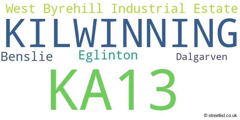
The KA13 postal code covers the settlement of KILWINNING.
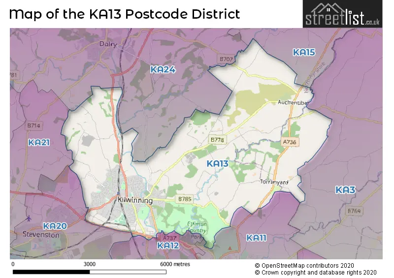
The KA13 Postcode shares a border with KA12 (IRVINE, Irvine Industrial Estate), KA20 (STEVENSTON), KA11 (Dreghorn, Girdle Toll, IRVINE), KA3 (KILMARNOCK, Stewarton, Kilmaurs), KA24 (DALRY) and KA15 (BEITH, Barrmill, Burnhouse).
The primary settlement in the KA13 postcode district is Kilwinning, which is located in the county of Ayrshire and Arran. Other significant settlements within this postcode district include Dalgarven, West Byrehill Industrial Estate, Benslie, and Eglinton. The postal town associated with this postcode district is Kilwinning.
For the district KA13, we have data on 3 postcode sectors. Here's a breakdown: The sector KA13 6, covers Kilwinning in Ayrshire and Arran. The sector KA13 7, covers Kilwinning in Ayrshire and Arran. The sector KA13 9 is non-geographic. It's often designated for PO Boxes, large organisations, or special services.

Map of the KA13 Postcode District
Explore the KA13 postcode district by using our free interactive map.
When it comes to local government, postal geography often disregards political borders. However, for a breakdown in the KA13 District: the district mostly encompasses the North Ayrshire area with a total of 454 postcodes.
Weather Forecast for KA13
Press Button to Show Forecast for Kilwinning
| Time Period | Icon | Description | Temperature | Rain Probability | Wind |
|---|---|---|---|---|---|
| 21:00 to 00:00 | Partly cloudy (night) | 5.0°C (feels like 3.0°C) | 1.00% | NNE 4 mph |
Press Button to Show Forecast for Kilwinning
| Time Period | Icon | Description | Temperature | Rain Probability | Wind |
|---|---|---|---|---|---|
| 00:00 to 03:00 | Partly cloudy (night) | 3.0°C (feels like 2.0°C) | 1.00% | NNE 2 mph | |
| 03:00 to 06:00 | Clear night | 2.0°C (feels like 0.0°C) | 0.00% | NE 4 mph | |
| 06:00 to 09:00 | Sunny day | 3.0°C (feels like 2.0°C) | 0.00% | NE 4 mph | |
| 09:00 to 12:00 | Partly cloudy (day) | 8.0°C (feels like 7.0°C) | 1.00% | ESE 2 mph | |
| 12:00 to 15:00 | Cloudy | 9.0°C (feels like 8.0°C) | 6.00% | SSW 4 mph | |
| 15:00 to 18:00 | Partly cloudy (day) | 10.0°C (feels like 8.0°C) | 4.00% | W 7 mph | |
| 18:00 to 21:00 | Partly cloudy (day) | 9.0°C (feels like 8.0°C) | 4.00% | WSW 4 mph | |
| 21:00 to 00:00 | Partly cloudy (night) | 6.0°C (feels like 5.0°C) | 2.00% | N 2 mph |
Press Button to Show Forecast for Kilwinning
| Time Period | Icon | Description | Temperature | Rain Probability | Wind |
|---|---|---|---|---|---|
| 00:00 to 03:00 | Partly cloudy (night) | 5.0°C (feels like 3.0°C) | 1.00% | NNE 4 mph | |
| 03:00 to 06:00 | Cloudy | 4.0°C (feels like 2.0°C) | 4.00% | NNE 4 mph | |
| 06:00 to 09:00 | Partly cloudy (day) | 5.0°C (feels like 2.0°C) | 2.00% | NNE 7 mph | |
| 09:00 to 12:00 | Sunny day | 8.0°C (feels like 7.0°C) | 1.00% | N 4 mph | |
| 12:00 to 15:00 | Cloudy | 10.0°C (feels like 9.0°C) | 5.00% | WNW 7 mph | |
| 15:00 to 18:00 | Partly cloudy (day) | 10.0°C (feels like 8.0°C) | 3.00% | W 11 mph | |
| 18:00 to 21:00 | Sunny day | 10.0°C (feels like 7.0°C) | 2.00% | WSW 11 mph | |
| 21:00 to 00:00 | Clear night | 7.0°C (feels like 5.0°C) | 4.00% | SW 9 mph |
Press Button to Show Forecast for Kilwinning
| Time Period | Icon | Description | Temperature | Rain Probability | Wind |
|---|---|---|---|---|---|
| 00:00 to 03:00 | Partly cloudy (night) | 7.0°C (feels like 4.0°C) | 5.00% | SSW 9 mph | |
| 03:00 to 06:00 | Cloudy | 7.0°C (feels like 4.0°C) | 9.00% | S 11 mph | |
| 06:00 to 09:00 | Cloudy | 8.0°C (feels like 5.0°C) | 11.00% | SSE 13 mph | |
| 09:00 to 12:00 | Cloudy | 10.0°C (feels like 7.0°C) | 16.00% | S 16 mph | |
| 12:00 to 15:00 | Light rain shower (day) | 11.0°C (feels like 7.0°C) | 40.00% | S 18 mph | |
| 15:00 to 18:00 | Light rain shower (day) | 11.0°C (feels like 8.0°C) | 38.00% | S 18 mph | |
| 18:00 to 21:00 | Cloudy | 11.0°C (feels like 8.0°C) | 16.00% | SSE 16 mph | |
| 21:00 to 00:00 | Cloudy | 10.0°C (feels like 7.0°C) | 14.00% | SSE 13 mph |
Press Button to Show Forecast for Kilwinning
| Time Period | Icon | Description | Temperature | Rain Probability | Wind |
|---|---|---|---|---|---|
| 00:00 to 03:00 | Cloudy | 10.0°C (feels like 7.0°C) | 12.00% | SE 11 mph | |
| 03:00 to 06:00 | Cloudy | 9.0°C (feels like 6.0°C) | 11.00% | SE 11 mph | |
| 06:00 to 09:00 | Partly cloudy (day) | 9.0°C (feels like 6.0°C) | 6.00% | ESE 11 mph | |
| 09:00 to 12:00 | Partly cloudy (day) | 11.0°C (feels like 9.0°C) | 7.00% | ESE 11 mph | |
| 12:00 to 15:00 | Cloudy | 14.0°C (feels like 11.0°C) | 11.00% | SE 13 mph | |
| 15:00 to 18:00 | Cloudy | 14.0°C (feels like 12.0°C) | 11.00% | ESE 11 mph | |
| 18:00 to 21:00 | Partly cloudy (day) | 14.0°C (feels like 12.0°C) | 6.00% | E 11 mph | |
| 21:00 to 00:00 | Partly cloudy (night) | 11.0°C (feels like 9.0°C) | 3.00% | ENE 11 mph |
Where is the KA13 Postcode District?
The data shows that the postcode district "KA13" is located in Kilwinning, a town in Scotland. Kilwinning is near several other towns, including Glasgow to the south (2.83 miles away), Stevenston to the southwest (4.11 miles away), Saltcoats to the west (4.41 miles away), Dalry to the northwest (4.84 miles away), Beith to the northeast (5.86 miles away), and Kilbirnie to the north (6.28 miles away). Additionally, the distance from Kilwinning to London is approximately 342.82 miles.
The district is within the post town of KILWINNING.
The sector has postcodes within the nation of Scotland.
The KA13 Postcode District is covers the following regions.
- Lochaber, Skye & Lochalsh, Arran & Cumbrae and Argyll & Bute - Highlands and Islands - Scotland
- East Ayrshire and North Ayrshire mainland - Southern Scotland - Scotland
| Postcode Sector | Delivery Office |
|---|---|
| KA13 6 | Kilwinning Delivery Office |
| KA13 7 | Kilwinning Delivery Office |
| K | A | 1 | 3 | - | X | X | X |
| K | A | 1 | 3 | Space | Numeric | Letter | Letter |
Current Monthly Rental Prices
| # Bedrooms | Min Price | Max Price | Avg Price |
|---|---|---|---|
| 1 | £495 | £495 | £495 |
| 2 | £495 | £565 | £530 |
Current House Prices
| # Bedrooms | Min Price | Max Price | Avg Price |
|---|---|---|---|
| £525,000 | £525,000 | £525,000 | |
| 1 | £35,000 | £67,000 | £51,000 |
| 2 | £37,500 | £99,000 | £65,385 |
| 3 | £56,000 | £150,000 | £102,333 |
| 4 | £129,995 | £285,000 | £220,666 |
| 5 | £265,000 | £373,000 | £319,000 |
Estate Agents who Operate in the KA13 District
| Logo | Name | Brand Name | Address | Contact Number | Total Properties |
|---|---|---|---|---|---|
 | Irvine | Lomond | 52 Bank Street, Irvine, KA12 0LP | 01294 442174 | 6 |
 | Ayr | Belmont Property Auctions | Ayr | 01292 431551 | 3 |
 | Saltcoats | Taylor & Henderson | 51 Hamilton Street, Saltcoats, KA21 5DX | 01294 442241 | 3 |
 | Irvine | Coast Estate Agents | 4-6 Townhead Irvine KA12 0BE | 01294 442310 | 2 |
 | Irvine | Donald Ross Residential | 9B Riverway Retail Park, Riverway, Irvine, KA12 8AG | 01294 442348 | 2 |