
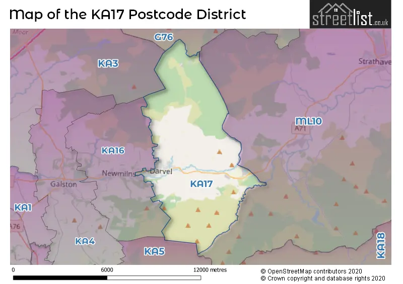
Map of the Postcode District
Explore the postcode district by using our interactive map.
Your support helps keep this site running!
If you enjoy using this website, consider buying me a coffee to help cover hosting costs.
The postcode district located in the KA Kilmarnock postal area , KA17 has a population of 4,100 residents according to the 2011 Scotland Census.
The area of the district is 22.80 square miles (59.05 square kilometers or 14,590.75 acres).
Where is the KA17 District?
To give you an idea where the district is located we have created the following table showing nearby towns.
Nearest Towns to KA17
| Town | Distance (miles) | Direction |
|---|---|---|
| Newmilns | 3.05 | WSW |
| Galston | 5.28 | WSW |
| Kilmarnock | 9.61 | W |
| East Kilbride | 10.05 | NNE |
| Stewarton | 11.11 | WNW |
| Cumnock | 11.50 | S |
| Larkhall | 13.52 | NE |
| Barrhead | 13.60 | NNW |
| Hamilton | 13.67 | NE |
| Rutherglen | 14.46 | N |
| Uddingston | 15.24 | NNE |
| Motherwell | 15.40 | NE |
| New Cumnock | 15.71 | S |
| Irvine | 16.25 | W |
| Bellshill | 16.29 | NNE |
| Prestwick | 16.48 | WSW |
| Wishaw | 16.67 | NE |
| Glasgow | 16.81 | N |
| Paisley | 17.01 | NNW |
The post town for this district is DARVEL.
Postcode Information for District KA17 (Total Geographical Postcodes: 141)
| Location | Post Town | Sector | Number of Postcodes |
|---|---|---|---|
| DARVEL | DARVEL | KA17 0 | 138 |
| Priestland | DARVEL | KA17 0 | 3 |
The primary settlement in the KA17 postcode district is Darvel, which is located in the county of Ayrshire and Arran. The most significant post town associated with this postcode district is Darvel.
When it comes to local government, postal geography often disregards political borders. However, this district intersects the following councils: the district mostly encompasses the East Ayrshire area with a total of 140 postal codes.
The largest settlements in the KA17 postal code are DARVEL and Priestland.
The KA17 Postcode shares a border with G76 (Clarkston, Eaglesham), ML10 (STRATHAVEN, Glassford, Chapelton) and KA16 (NEWMILNS).
Postcode Sectors


Stations in the Sector
No stations found in this postcode district.
Accessable Motorway Junctions
M77 J7
Average Driving Time from within the district: 17.70
Average Driving Distance: 11.24
Number of Postcodes that can access the Motorway Junction: 141
M77 J8
Average Driving Time from within the district: 17.81
Average Driving Distance: 12.25
Number of Postcodes that can access the Motorway Junction: 141
M77 J6
Average Driving Time from within the district: 17.93
Average Driving Distance: 11.44
Number of Postcodes that can access the Motorway Junction: 141
M77 J5
Average Driving Time from within the district: 22.90
Average Driving Distance: 16.51
Number of Postcodes that can access the Motorway Junction: 141
M77 J4
Average Driving Time from within the district: 24.99
Average Driving Distance: 18.48
Number of Postcodes that can access the Motorway Junction: 135
Weather Forecast for Darvel
| Time Period | Icon | Description | Temperature | Rain Probability | Wind |
|---|---|---|---|---|---|
| 12:00 to 15:00 | Cloudy | 11.0°C (feels like 9.0°C) | 16.00% | WSW 13 mph | |
| 15:00 to 18:00 | Cloudy | 11.0°C (feels like 9.0°C) | 8.00% | WSW 11 mph | |
| 18:00 to 21:00 | Partly cloudy (night) | 9.0°C (feels like 8.0°C) | 1.00% | SSW 7 mph | |
| 21:00 to 00:00 | Cloudy | 10.0°C (feels like 8.0°C) | 4.00% | SSW 9 mph |
| Time Period | Icon | Description | Temperature | Rain Probability | Wind |
|---|---|---|---|---|---|
| 00:00 to 03:00 | Cloudy | 9.0°C (feels like 7.0°C) | 4.00% | SSW 11 mph | |
| 03:00 to 06:00 | Cloudy | 10.0°C (feels like 7.0°C) | 12.00% | SSW 11 mph | |
| 06:00 to 09:00 | Overcast | 10.0°C (feels like 8.0°C) | 51.00% | SW 11 mph | |
| 09:00 to 12:00 | Overcast | 11.0°C (feels like 9.0°C) | 7.00% | SSW 11 mph | |
| 12:00 to 15:00 | Cloudy | 13.0°C (feels like 11.0°C) | 4.00% | SSW 13 mph | |
| 15:00 to 18:00 | Cloudy | 13.0°C (feels like 11.0°C) | 4.00% | SSW 11 mph | |
| 18:00 to 21:00 | Cloudy | 11.0°C (feels like 9.0°C) | 5.00% | SSW 11 mph | |
| 21:00 to 00:00 | Cloudy | 12.0°C (feels like 9.0°C) | 9.00% | S 13 mph |
| Time Period | Icon | Description | Temperature | Rain Probability | Wind |
|---|---|---|---|---|---|
| 00:00 to 03:00 | Cloudy | 12.0°C (feels like 10.0°C) | 10.00% | SSW 16 mph | |
| 03:00 to 06:00 | Cloudy | 12.0°C (feels like 9.0°C) | 6.00% | S 16 mph | |
| 06:00 to 09:00 | Overcast | 11.0°C (feels like 8.0°C) | 7.00% | S 16 mph | |
| 09:00 to 12:00 | Cloudy | 12.0°C (feels like 9.0°C) | 5.00% | S 16 mph | |
| 12:00 to 15:00 | Overcast | 13.0°C (feels like 10.0°C) | 10.00% | S 16 mph | |
| 15:00 to 18:00 | Overcast | 13.0°C (feels like 10.0°C) | 14.00% | SSE 16 mph | |
| 18:00 to 21:00 | Overcast | 12.0°C (feels like 10.0°C) | 24.00% | S 13 mph | |
| 21:00 to 00:00 | Heavy rain | 12.0°C (feels like 10.0°C) | 75.00% | SSW 9 mph |
| Time Period | Icon | Description | Temperature | Rain Probability | Wind |
|---|---|---|---|---|---|
| 00:00 to 03:00 | Light rain | 12.0°C (feels like 10.0°C) | 53.00% | S 9 mph | |
| 03:00 to 06:00 | Heavy rain | 11.0°C (feels like 9.0°C) | 70.00% | SW 7 mph | |
| 06:00 to 09:00 | Cloudy | 10.0°C (feels like 8.0°C) | 25.00% | NW 7 mph | |
| 09:00 to 12:00 | Light rain shower (day) | 10.0°C (feels like 8.0°C) | 40.00% | NNW 9 mph | |
| 12:00 to 15:00 | Heavy rain shower (day) | 11.0°C (feels like 9.0°C) | 58.00% | NNW 9 mph | |
| 15:00 to 18:00 | Light rain shower (day) | 11.0°C (feels like 9.0°C) | 42.00% | N 9 mph | |
| 18:00 to 21:00 | Partly cloudy (night) | 9.0°C (feels like 7.0°C) | 12.00% | NNW 7 mph | |
| 21:00 to 00:00 | Partly cloudy (night) | 8.0°C (feels like 7.0°C) | 8.00% | W 7 mph |
| Time Period | Icon | Description | Temperature | Rain Probability | Wind |
|---|---|---|---|---|---|
| 00:00 to 03:00 | Cloudy | 8.0°C (feels like 7.0°C) | 15.00% | WSW 7 mph | |
| 03:00 to 06:00 | Cloudy | 8.0°C (feels like 6.0°C) | 25.00% | SW 9 mph | |
| 06:00 to 09:00 | Cloudy | 9.0°C (feels like 6.0°C) | 31.00% | SW 9 mph | |
| 09:00 to 12:00 | Light rain | 9.0°C (feels like 7.0°C) | 58.00% | SW 11 mph | |
| 12:00 to 15:00 | Heavy rain shower (day) | 10.0°C (feels like 7.0°C) | 56.00% | SW 13 mph | |
| 15:00 to 18:00 | Light rain shower (day) | 10.0°C (feels like 7.0°C) | 41.00% | WSW 13 mph | |
| 18:00 to 21:00 | Partly cloudy (night) | 9.0°C (feels like 6.0°C) | 15.00% | WSW 11 mph | |
| 21:00 to 00:00 | Partly cloudy (night) | 8.0°C (feels like 5.0°C) | 16.00% | WSW 11 mph |
| Postal Sector | Delivery Office |
|---|---|
| KA17 0 | Kilmarnock Delivery Office |
| K | A | 1 | 7 | - | X | X | X |
| K | A | 1 | 7 | Space | Numeric | Letter | Letter |
Street List for the KA17 District
Current Monthly Rental Prices
| # Bedrooms | Min Price | Max Price | Avg Price |
|---|
Current House Prices
| # Bedrooms | Min Price | Max Price | Avg Price |
|---|---|---|---|
| 1 | £23,000 | £23,000 | £23,000 |
| 3 | £139,995 | £180,000 | £159,998 |
| 4 | £360,000 | £360,000 | £360,000 |
| 6 | £295,000 | £295,000 | £295,000 |
Estate Agents
| Logo | Name | Brand Name | Address | Contact Number |
|---|---|---|---|---|
 | Glasgow | Future Property Auctions | 241 Kilmarnock Road Glasgow G41 3JF | 0141 632 6599 |
 | Newmilns | Greig Residential | 18 Henrietta Street Galston KA4 8HQ | 01563 501350 |
 | Kilmarnock | Glow Homes Ayrshire | 37 John Finnie Street, Kilmarnock, KA1 1BL | 01563 597196 |
 | covering Kilmarnock | Purplebricks | Suite 7 First Floor Cranmore Drive Shirley Solihull B90 4RZ | 020 3909 4056 |
 | Ayr | Stonefield Estate Agents | 16A Beresford Terrace, Ayr, KA7 2EG | 01292 501777 |