The ML10 postcode district is a postal district located in the ML Motherwell postcode area with a population of 10,522 residents according to the 2011 Scotland Census.
The area of the ML10 postcode district is 79.13 square miles which is 204.95 square kilometres or 50,644.16 acres.
Currently, the ML10 district has about 333 postcode units spread across 1 geographic postcode sectors.
Given that each sector allows for 400 unique postcode combinations, the district has a capacity of 400 postcodes. With 333 postcodes already in use, this leaves 67 units available.
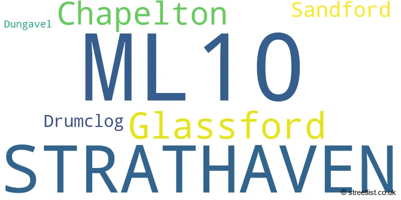
The largest settlement in the ML10 postal code is STRATHAVEN followed by Glassford, and Chapelton.
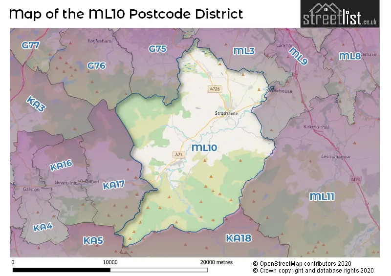
The ML10 Postcode shares a border with ML11 (LANARK, Lesmahagow, Forth), ML9 (LARKHALL, Stonehouse, Ashgill), G75 (East Kilbride), KA17 (DARVEL, Priestland), KA18 (CUMNOCK, Auchinleck, New Cumnock), KA5 (MAUCHLINE, Catrine, Tarbolton) and ML3 (HAMILTON, Ferniegair, Quarter).
The ML10 postcode district in Lanarkshire, Scotland includes the primary settlement of Strathaven. Other significant settlements in this district are Chapelton, Drumclog, Dungavel, Glassford, and Sandford. The most significant post town within the ML10 district is also Strathaven.
For the district ML10, we have data on 1 postcode sectors. Here's a breakdown: The sector ML10 6, covers Strathaven in Lanarkshire.
ML10 Postcode Sectors

Map of the ML10 Postcode District
Explore the ML10 postcode district by using our free interactive map.
When it comes to local government, postal geography often disregards political borders. However, for a breakdown in the ML10 District: the district mostly encompasses the South Lanarkshire area with a total of 344 postcodes.
Where is the ML10 Postcode District?
The postcode district ML10 is located in the town of Strathaven. It is in close proximity to several nearby towns. To the West, there is Darvel which is approximately 5.6 miles away. To the North, there is Hamilton which is around 7.7 miles away. To the North West, there is Bonnyrigg which is approximately 8.5 miles away. Lastly, to the North East, there is Larkhall which is around 8.5 miles away. Additionally, ML10 is located approximately 329.7 miles away from the center of London.
The district is within the post town of STRATHAVEN.
The sector has postcodes within the nation of Scotland.
The ML10 Postcode District is in the South Lanarkshire region of Southern Scotland within the Scotland.
Weather Forecast for ML10
Press Button to Show Forecast for Strathaven
| Time Period | Icon | Description | Temperature | Rain Probability | Wind |
|---|---|---|---|---|---|
| 12:00 to 15:00 | Cloudy | 18.0°C (feels like 17.0°C) | 9.00% | SSE 7 mph | |
| 15:00 to 18:00 | Cloudy | 20.0°C (feels like 18.0°C) | 10.00% | S 9 mph | |
| 18:00 to 21:00 | Light rain shower (day) | 18.0°C (feels like 17.0°C) | 34.00% | SSE 9 mph | |
| 21:00 to 00:00 | Light rain shower (night) | 14.0°C (feels like 14.0°C) | 33.00% | SSE 4 mph |
Press Button to Show Forecast for Strathaven
| Time Period | Icon | Description | Temperature | Rain Probability | Wind |
|---|---|---|---|---|---|
| 00:00 to 03:00 | Light rain shower (night) | 13.0°C (feels like 12.0°C) | 33.00% | ESE 4 mph | |
| 03:00 to 06:00 | Cloudy | 12.0°C (feels like 11.0°C) | 11.00% | ESE 4 mph | |
| 06:00 to 09:00 | Cloudy | 13.0°C (feels like 12.0°C) | 11.00% | E 4 mph | |
| 09:00 to 12:00 | Cloudy | 16.0°C (feels like 16.0°C) | 7.00% | E 7 mph | |
| 12:00 to 15:00 | Cloudy | 19.0°C (feels like 17.0°C) | 31.00% | SE 9 mph | |
| 15:00 to 18:00 | Cloudy | 18.0°C (feels like 18.0°C) | 15.00% | SSE 7 mph | |
| 18:00 to 21:00 | Cloudy | 17.0°C (feels like 17.0°C) | 11.00% | SE 4 mph | |
| 21:00 to 00:00 | Cloudy | 13.0°C (feels like 13.0°C) | 11.00% | E 4 mph |
Press Button to Show Forecast for Strathaven
| Time Period | Icon | Description | Temperature | Rain Probability | Wind |
|---|---|---|---|---|---|
| 00:00 to 03:00 | Cloudy | 13.0°C (feels like 12.0°C) | 15.00% | ESE 4 mph | |
| 03:00 to 06:00 | Cloudy | 13.0°C (feels like 12.0°C) | 13.00% | E 4 mph | |
| 06:00 to 09:00 | Cloudy | 13.0°C (feels like 12.0°C) | 10.00% | E 7 mph | |
| 09:00 to 12:00 | Cloudy | 15.0°C (feels like 14.0°C) | 18.00% | E 9 mph | |
| 12:00 to 15:00 | Light rain shower (day) | 17.0°C (feels like 15.0°C) | 40.00% | ESE 9 mph | |
| 15:00 to 18:00 | Light rain shower (day) | 17.0°C (feels like 16.0°C) | 44.00% | E 9 mph | |
| 18:00 to 21:00 | Light rain shower (day) | 15.0°C (feels like 14.0°C) | 40.00% | ENE 9 mph | |
| 21:00 to 00:00 | Cloudy | 13.0°C (feels like 12.0°C) | 16.00% | ENE 7 mph |
Press Button to Show Forecast for Strathaven
| Time Period | Icon | Description | Temperature | Rain Probability | Wind |
|---|---|---|---|---|---|
| 00:00 to 03:00 | Cloudy | 12.0°C (feels like 11.0°C) | 13.00% | ENE 7 mph | |
| 03:00 to 06:00 | Partly cloudy (night) | 12.0°C (feels like 11.0°C) | 6.00% | ENE 4 mph | |
| 06:00 to 09:00 | Cloudy | 12.0°C (feels like 12.0°C) | 7.00% | E 4 mph | |
| 09:00 to 12:00 | Cloudy | 16.0°C (feels like 15.0°C) | 7.00% | ESE 7 mph | |
| 12:00 to 15:00 | Cloudy | 19.0°C (feels like 18.0°C) | 14.00% | ESE 7 mph | |
| 15:00 to 18:00 | Partly cloudy (day) | 19.0°C (feels like 18.0°C) | 14.00% | ESE 7 mph | |
| 18:00 to 21:00 | Light rain shower (day) | 18.0°C (feels like 17.0°C) | 36.00% | ESE 7 mph | |
| 21:00 to 00:00 | Partly cloudy (night) | 13.0°C (feels like 13.0°C) | 4.00% | E 4 mph |
Press Button to Show Forecast for Strathaven
| Time Period | Icon | Description | Temperature | Rain Probability | Wind |
|---|---|---|---|---|---|
| 00:00 to 03:00 | Partly cloudy (night) | 11.0°C (feels like 10.0°C) | 3.00% | E 4 mph | |
| 03:00 to 06:00 | Cloudy | 10.0°C (feels like 9.0°C) | 7.00% | E 4 mph | |
| 06:00 to 09:00 | Overcast | 11.0°C (feels like 11.0°C) | 12.00% | E 4 mph | |
| 09:00 to 12:00 | Cloudy | 15.0°C (feels like 15.0°C) | 10.00% | SE 4 mph | |
| 12:00 to 15:00 | Cloudy | 17.0°C (feels like 17.0°C) | 15.00% | SSW 7 mph | |
| 15:00 to 18:00 | Cloudy | 18.0°C (feels like 17.0°C) | 15.00% | SW 7 mph | |
| 18:00 to 21:00 | Light rain shower (day) | 17.0°C (feels like 16.0°C) | 31.00% | NNW 7 mph | |
| 21:00 to 00:00 | Cloudy | 12.0°C (feels like 12.0°C) | 7.00% | NNW 4 mph |
Postcode Sectors within the ML10 District
| Postcode Sector | Delivery Office |
|---|---|
| ML10 6 | Larkhall Delivery Office |
| M | L | 1 | 0 | - | X | X | X |
| M | L | 1 | 0 | Space | Numeric | Letter | Letter |
Current Monthly Rental Prices
| # Bedrooms | Min Price | Max Price | Avg Price |
|---|---|---|---|
| 1 | £525 | £525 | £525 |
| 2 | £675 | £675 | £675 |
| 3 | £995 | £995 | £995 |
| 4 | £1,300 | £1,300 | £1,300 |
Current House Prices
| # Bedrooms | Min Price | Max Price | Avg Price |
|---|---|---|---|
| £80,000 | £80,000 | £80,000 | |
| 1 | £44,995 | £130,000 | £87,498 |
| 2 | £115,000 | £419,995 | £252,499 |
| 3 | £199,995 | £299,995 | £237,276 |
| 4 | £295,000 | £465,000 | £368,768 |
| 5 | £320,000 | £699,000 | £466,863 |
| 7 | £1,199,000 | £1,199,000 | £1,199,000 |
Estate Agents who Operate in the ML10 District
| Logo | Name | Brand Name | Address | Contact Number | Total Properties |
|---|---|---|---|---|---|
 | Strathaven | Residence Estate Agents | 3 Bridge Street, Strathaven, ML10 6AN | 01357 513033 | 15 |
 | Bothwell | Clyde Property | 47 Main Street, Bothwell, Glasgow, G71 8ER | 01698 757087 | 5 |
 | Strathaven | Gebbie & Wilson | 18 Common Green, Strathaven, ML10 6AG | 01357 513030 | 5 |
 | Scotland | Yopa | Meridian House Wheatfield Way Hinckley LE10 1YG | 0161 524 0574 | 3 |
 | Hamilton | Igloo | 2 Gateside Street Hamilton ML3 7JG | 01698 533984 | 3 |