The KW7 postcode district is a postal district located in the KW Kirkwall postcode area with a population of 96 residents according to the 2011 Scotland Census.
The area of the KW7 postcode district is 79.69 square miles which is 206.39 square kilometres or 51,000.33 acres.
Currently, the KW7 district has about 5 postcode units spread across 1 geographic postcode sectors.
Given that each sector allows for 400 unique postcode combinations, the district has a capacity of 400 postcodes. With 5 postcodes already in use, this leaves 395 units available.
The KW7 postal code covers the settlement of BERRIEDALE.
The postcode area has a boundary with The Moray Firth.
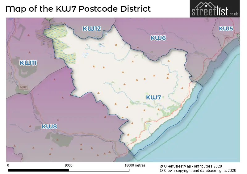
The KW7 Postcode shares a border with KW12 (HALKIRK, Altnabreac, Westerdale), KW6 (DUNBEATH, Braemore, Knockally) and KW8 (HELMSDALE, Kildonan, Loth).
The primary settlement in the KW7 postcode district is Berriedale, located in the county of Caithness, Scotland. There are also other significant settlements in the district, but they are not mentioned in the given data. The most significant post town in the district is Berriedale.
For the district KW7, we have data on 1 postcode sectors. Here's a breakdown: The sector KW7 6, covers Berriedale in Caithness.
KW7 Postcode Sectors

Map of the KW7 Postcode District
Explore the KW7 postcode district by using our free interactive map.
When it comes to local government, postal geography often disregards political borders. However, for a breakdown in the KW7 District: the district mostly encompasses the Highland area with a total of 5 postcodes.
Where is the KW7 Postcode District?
The data shows that the postcode district KW7 is located in the town of Berriedale. Berriedale is situated in the north of Scotland. Some nearby towns to Berriedale include Helmsdale to the south, Dunbeath to the east, Latheron to the northeast, Brora to the southwest, Kinbrace to the west, Forsinard to the northwest, and Halkirk to the north. The distance from Berriedale to London is approximately 484.6 miles.
The district is within the post town of BERRIEDALE.
The sector has postcodes within the nation of Scotland.
The KW7 Postcode District is covers the following regions.
- Caithness & Sutherland and Ross & Cromarty - Highlands and Islands - Scotland
- Inverness & Nairn and Moray, Badenoch & Strathspey - Highlands and Islands - Scotland
- Lochaber, Skye & Lochalsh, Arran & Cumbrae and Argyll & Bute - Highlands and Islands - Scotland
Weather Forecast for KW7
Press Button to Show Forecast for Helmsdale Youth Hostel
| Time Period | Icon | Description | Temperature | Rain Probability | Wind |
|---|---|---|---|---|---|
| 12:00 to 15:00 | Cloudy | 16.0°C (feels like 15.0°C) | 3.00% | S 4 mph | |
| 15:00 to 18:00 | Cloudy | 17.0°C (feels like 16.0°C) | 3.00% | ESE 7 mph | |
| 18:00 to 21:00 | Partly cloudy (day) | 16.0°C (feels like 15.0°C) | 0.00% | ESE 7 mph | |
| 21:00 to 00:00 | Clear night | 15.0°C (feels like 14.0°C) | 0.00% | WSW 7 mph |
Press Button to Show Forecast for Helmsdale Youth Hostel
| Time Period | Icon | Description | Temperature | Rain Probability | Wind |
|---|---|---|---|---|---|
| 00:00 to 03:00 | Partly cloudy (night) | 13.0°C (feels like 13.0°C) | 1.00% | SW 4 mph | |
| 03:00 to 06:00 | Partly cloudy (night) | 10.0°C (feels like 10.0°C) | 3.00% | SSE 2 mph | |
| 06:00 to 09:00 | Sunny day | 13.0°C (feels like 13.0°C) | 0.00% | SSE 4 mph | |
| 09:00 to 12:00 | Sunny day | 15.0°C (feels like 15.0°C) | 0.00% | SSE 4 mph | |
| 12:00 to 15:00 | Sunny day | 17.0°C (feels like 17.0°C) | 0.00% | E 4 mph | |
| 15:00 to 18:00 | Sunny day | 18.0°C (feels like 17.0°C) | 0.00% | E 7 mph | |
| 18:00 to 21:00 | Partly cloudy (day) | 17.0°C (feels like 16.0°C) | 1.00% | ESE 7 mph | |
| 21:00 to 00:00 | Cloudy | 15.0°C (feels like 15.0°C) | 4.00% | SE 4 mph |
Press Button to Show Forecast for Helmsdale Youth Hostel
| Time Period | Icon | Description | Temperature | Rain Probability | Wind |
|---|---|---|---|---|---|
| 00:00 to 03:00 | Cloudy | 14.0°C (feels like 13.0°C) | 4.00% | SE 4 mph | |
| 03:00 to 06:00 | Partly cloudy (night) | 13.0°C (feels like 12.0°C) | 1.00% | SE 7 mph | |
| 06:00 to 09:00 | Cloudy | 14.0°C (feels like 13.0°C) | 4.00% | SSE 7 mph | |
| 09:00 to 12:00 | Cloudy | 16.0°C (feels like 15.0°C) | 6.00% | SE 7 mph | |
| 12:00 to 15:00 | Cloudy | 17.0°C (feels like 16.0°C) | 6.00% | SE 7 mph | |
| 15:00 to 18:00 | Cloudy | 17.0°C (feels like 15.0°C) | 11.00% | SE 9 mph | |
| 18:00 to 21:00 | Cloudy | 15.0°C (feels like 14.0°C) | 15.00% | SE 9 mph | |
| 21:00 to 00:00 | Cloudy | 13.0°C (feels like 12.0°C) | 13.00% | SE 9 mph |
Press Button to Show Forecast for Helmsdale Youth Hostel
| Time Period | Icon | Description | Temperature | Rain Probability | Wind |
|---|---|---|---|---|---|
| 00:00 to 03:00 | Cloudy | 12.0°C (feels like 10.0°C) | 11.00% | ENE 9 mph | |
| 03:00 to 06:00 | Cloudy | 11.0°C (feels like 9.0°C) | 16.00% | ENE 9 mph | |
| 06:00 to 09:00 | Cloudy | 11.0°C (feels like 10.0°C) | 16.00% | ESE 9 mph | |
| 09:00 to 12:00 | Cloudy | 12.0°C (feels like 10.0°C) | 20.00% | ESE 11 mph | |
| 12:00 to 15:00 | Cloudy | 13.0°C (feels like 11.0°C) | 12.00% | E 11 mph | |
| 15:00 to 18:00 | Cloudy | 14.0°C (feels like 13.0°C) | 10.00% | ESE 9 mph | |
| 18:00 to 21:00 | Cloudy | 14.0°C (feels like 12.0°C) | 13.00% | E 9 mph | |
| 21:00 to 00:00 | Cloudy | 12.0°C (feels like 11.0°C) | 14.00% | ESE 9 mph |
Press Button to Show Forecast for Helmsdale Youth Hostel
| Time Period | Icon | Description | Temperature | Rain Probability | Wind |
|---|---|---|---|---|---|
| 00:00 to 03:00 | Cloudy | 11.0°C (feels like 10.0°C) | 17.00% | ENE 9 mph | |
| 03:00 to 06:00 | Light rain | 11.0°C (feels like 9.0°C) | 47.00% | ENE 9 mph | |
| 06:00 to 09:00 | Light rain | 11.0°C (feels like 9.0°C) | 44.00% | ENE 9 mph | |
| 09:00 to 12:00 | Light rain | 12.0°C (feels like 10.0°C) | 46.00% | E 11 mph | |
| 12:00 to 15:00 | Partly cloudy (day) | 13.0°C (feels like 11.0°C) | 10.00% | E 11 mph | |
| 15:00 to 18:00 | Cloudy | 13.0°C (feels like 11.0°C) | 14.00% | E 13 mph | |
| 18:00 to 21:00 | Partly cloudy (day) | 13.0°C (feels like 11.0°C) | 9.00% | ENE 13 mph | |
| 21:00 to 00:00 | Partly cloudy (night) | 12.0°C (feels like 10.0°C) | 8.00% | ENE 11 mph |
Postcode Sectors within the KW7 District
| Postcode Sector | Delivery Office |
|---|---|
| KW7 6 | Dunbeath Scale Payment Delivery Office |
| K | W | 7 | - | X | X | X |
| K | W | 7 | Space | Numeric | Letter | Letter |
Current Monthly Rental Prices
| # Bedrooms | Min Price | Max Price | Avg Price |
|---|
Current House Prices
| # Bedrooms | Min Price | Max Price | Avg Price |
|---|
Estate Agents who Operate in the KW7 District
| Logo | Name | Brand Name | Address | Contact Number | Total Properties |
|---|