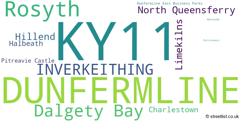
The KY11 postcode district is a postal district located in the KY Kirkcaldy postcode area with a population of 60,574 residents according to the 2011 Scotland Census.
The area of the KY11 postcode district is 19.77 square miles which is 51.21 square kilometres or 12,654.70 acres.
Currently, the KY11 district has about 1379 postcode units spread across 7 geographic postcode sectors.
Given that each sector allows for 400 unique postcode combinations, the district has a capacity of 2,800 postcodes. With 1379 postcodes already in use, this leaves 1421 units available.
The largest settlement in the KY11 postal code is DUNFERMLINE followed by Rosyth, and Dalgety Bay.
The postcode area has a boundary with Firth of Forth.
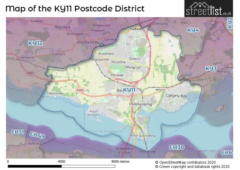
The KY11 Postcode shares a border with KY3 (BURNTISLAND, Kinghorn, Aberdour), KY4 (COWDENBEATH, KELTY, Crossgates) and KY12 (DUNFERMLINE, Cairneyhill, Oakley).
The primary settlement in the KY11 postcode district is Inverkeithing, located in the county of Fife, Scotland. Other significant settlements in the district include Burnside and North Queensferry. The post town for the KY11 postcode district is Inverkeithing.
For the district KY11, we have data on 7 postcode sectors. Here's a breakdown: The sector KY11 1, covers Inverkeithing and North Queensferry in Fife. The sector KY11 2, covers Rosyth in Fife. The sector KY11 3, covers Dunfermline and Limekilns and Charlestown in Fife. The sector KY11 4, covers Dunfermline in Fife. The sector KY11 7, covers Dunfermline and Hillend and Halbeath in Fife. The sector KY11 8, covers Dunfermline in Fife. The sector KY11 9, covers Dalgety Bay and Hillend in Fife.

Map of the KY11 Postcode District
Explore the KY11 postcode district by using our free interactive map.
When it comes to local government, postal geography often disregards political borders. However, for a breakdown in the KY11 District: the district mostly encompasses the Fife area with a total of 1383 postcodes.
Where is the KY11 Postcode District?
The postcode district for KY11 is located in Dunfermline. Dunfermline is a town in Scotland. Nearby towns include Grantown-on-Spey to the southwest, Cowdenbeath to the northeast, South Queensferry to the south, Inverkeithing to the east, and Kelty to the north. The distance to London from KY11 is approximately 341.47 miles.
The district covers the post towns of DUNFERMLINE, INVERKEITHING.
The sector has postcodes within the nation of Scotland.
The KY11 Postcode District is in the region of within the .
Weather Forecast for KY11
Press Button to Show Forecast for Rosyth
| Time Period | Icon | Description | Temperature | Rain Probability | Wind |
|---|---|---|---|---|---|
| 21:00 to 00:00 | Clear night | 14.0°C (feels like 14.0°C) | 1.00% | SSE 4 mph |
Press Button to Show Forecast for Rosyth
| Time Period | Icon | Description | Temperature | Rain Probability | Wind |
|---|---|---|---|---|---|
| 00:00 to 03:00 | Clear night | 13.0°C (feels like 13.0°C) | 0.00% | W 4 mph | |
| 03:00 to 06:00 | Clear night | 11.0°C (feels like 11.0°C) | 0.00% | WNW 2 mph | |
| 06:00 to 09:00 | Sunny day | 13.0°C (feels like 13.0°C) | 0.00% | ESE 2 mph | |
| 09:00 to 12:00 | Sunny day | 17.0°C (feels like 17.0°C) | 1.00% | SE 4 mph | |
| 12:00 to 15:00 | Partly cloudy (day) | 20.0°C (feels like 19.0°C) | 42.00% | ESE 7 mph | |
| 15:00 to 18:00 | Light rain shower (day) | 20.0°C (feels like 19.0°C) | 41.00% | SSE 7 mph | |
| 18:00 to 21:00 | Light rain | 18.0°C (feels like 18.0°C) | 55.00% | ESE 7 mph | |
| 21:00 to 00:00 | Cloudy | 16.0°C (feels like 15.0°C) | 5.00% | E 4 mph |
Press Button to Show Forecast for Rosyth
| Time Period | Icon | Description | Temperature | Rain Probability | Wind |
|---|---|---|---|---|---|
| 00:00 to 03:00 | Cloudy | 14.0°C (feels like 14.0°C) | 6.00% | E 4 mph | |
| 03:00 to 06:00 | Cloudy | 13.0°C (feels like 12.0°C) | 8.00% | ESE 4 mph | |
| 06:00 to 09:00 | Cloudy | 14.0°C (feels like 13.0°C) | 8.00% | ESE 4 mph | |
| 09:00 to 12:00 | Cloudy | 16.0°C (feels like 15.0°C) | 8.00% | SE 7 mph | |
| 12:00 to 15:00 | Cloudy | 18.0°C (feels like 16.0°C) | 14.00% | SE 9 mph | |
| 15:00 to 18:00 | Cloudy | 18.0°C (feels like 16.0°C) | 19.00% | SE 11 mph | |
| 18:00 to 21:00 | Cloudy | 16.0°C (feels like 14.0°C) | 17.00% | ESE 9 mph | |
| 21:00 to 00:00 | Cloudy | 13.0°C (feels like 11.0°C) | 16.00% | ESE 7 mph |
Press Button to Show Forecast for Rosyth
| Time Period | Icon | Description | Temperature | Rain Probability | Wind |
|---|---|---|---|---|---|
| 00:00 to 03:00 | Cloudy | 11.0°C (feels like 10.0°C) | 17.00% | E 7 mph | |
| 03:00 to 06:00 | Overcast | 11.0°C (feels like 9.0°C) | 21.00% | ENE 7 mph | |
| 06:00 to 09:00 | Overcast | 11.0°C (feels like 10.0°C) | 23.00% | ENE 7 mph | |
| 09:00 to 12:00 | Cloudy | 13.0°C (feels like 12.0°C) | 18.00% | ESE 7 mph | |
| 12:00 to 15:00 | Light rain shower (day) | 16.0°C (feels like 15.0°C) | 41.00% | SE 7 mph | |
| 15:00 to 18:00 | Light rain | 15.0°C (feels like 14.0°C) | 55.00% | ESE 11 mph | |
| 18:00 to 21:00 | Light rain shower (day) | 14.0°C (feels like 13.0°C) | 41.00% | ESE 9 mph | |
| 21:00 to 00:00 | Light rain | 12.0°C (feels like 10.0°C) | 53.00% | E 9 mph |
Press Button to Show Forecast for Rosyth
| Time Period | Icon | Description | Temperature | Rain Probability | Wind |
|---|---|---|---|---|---|
| 00:00 to 03:00 | Light rain | 11.0°C (feels like 10.0°C) | 50.00% | E 9 mph | |
| 03:00 to 06:00 | Light rain | 11.0°C (feels like 9.0°C) | 46.00% | ESE 7 mph | |
| 06:00 to 09:00 | Light rain shower (day) | 11.0°C (feels like 9.0°C) | 34.00% | E 9 mph | |
| 09:00 to 12:00 | Light rain | 12.0°C (feels like 11.0°C) | 44.00% | ESE 9 mph | |
| 12:00 to 15:00 | Light rain shower (day) | 14.0°C (feels like 12.0°C) | 37.00% | ESE 11 mph | |
| 15:00 to 18:00 | Light rain shower (day) | 14.0°C (feels like 12.0°C) | 39.00% | ESE 11 mph | |
| 18:00 to 21:00 | Light rain | 13.0°C (feels like 11.0°C) | 47.00% | ESE 9 mph | |
| 21:00 to 00:00 | Overcast | 11.0°C (feels like 9.0°C) | 13.00% | SE 9 mph |
| Postcode Sector | Delivery Office |
|---|---|
| KY11 1 | Dunfermline Delivery Office |
| KY11 2 | Dunfermline Delivery Office |
| KY11 3 | Dunfermline Delivery Office |
| KY11 3 | Limekilns Scale Payment Delivery Office |
| KY11 4 | Dunfermline Delivery Office |
| KY11 7 | Dunfermline Delivery Office |
| KY11 8 | Dunfermline Delivery Office |
| KY11 9 | Dunfermline Delivery Office |
| K | Y | 1 | 1 | - | X | X | X |
| K | Y | 1 | 1 | Space | Numeric | Letter | Letter |
Current Monthly Rental Prices
| # Bedrooms | Min Price | Max Price | Avg Price |
|---|---|---|---|
| £150 | £150 | £150 | |
| 2 | £580 | £750 | £686 |
| 3 | £1,250 | £1,250 | £1,250 |
| 4 | £1,195 | £1,695 | £1,462 |
Current House Prices
| # Bedrooms | Min Price | Max Price | Avg Price |
|---|---|---|---|
| £55,000 | £975,000 | £296,667 | |
| 1 | £80,000 | £90,000 | £85,000 |
| 2 | £65,000 | £240,000 | £126,375 |
| 3 | £85,000 | £395,000 | £231,881 |
| 4 | £153,000 | £750,000 | £343,645 |
| 5 | £260,000 | £640,000 | £398,200 |
| 7 | £349,995 | £349,995 | £349,995 |
Estate Agents who Operate in the KY11 District
| Logo | Name | Brand Name | Address | Contact Number | Total Properties |
|---|---|---|---|---|---|
 | Dunfermline | YOUR MOVE | 11 New Row, Dunfermline, KY12 7EA | 020 3835 2544 | 14 |
 | Dunfermline | Morgans | 33 East Port, Dunfermline, KY12 7JE | 01383 663801 | 10 |
 | Dalgety Bay | Regents Estates & Mortgages | 6 Moray Way North, Dalgety Bay, KY11 9NH | 020 3835 4939 | 10 |
 | Dunfermline | Maloco Mowat Parker | 6/8 Bonnar Street, Dunfermline, KY12 7JR | 01383 663834 | 8 |
 | Dalgety Bay | YOUR MOVE | 11 Regents Way, The Bay Centre, Dalgety Bay, KY11 9YD | 020 3873 8394 | 7 |