The L11 0 postcode sector is within the county of Merseyside.
Did you know? According to the 2021 Census, the L11 0 postcode sector is home to a bustling 1,617 residents!
Given that each sector allows for 400 unique postcode combinations. Letters C, I, K, M, O and V are not allowed in the last two letters of a postcode. With 46 postcodes already in use, this leaves 354 units available.
The largest settlement in the L11 0 postal code is LIVERPOOL followed by Gilmoss Industrial Estate, and West Derby.
The L11 0 Postcode shares a border with L11 6 (LIVERPOOL, Croxteth), L32 7 (LIVERPOOL, Kirkby), L32 9 (LIVERPOOL, Kirkby), L10 4 (LIVERPOOL, Fazakerley), L11 4 (LIVERPOOL, Croxteth), L11 9 (LIVERPOOL, Croxteth) and L12 0 (LIVERPOOL, West Derby).
The sector is within the post town of LIVERPOOL.
L11 0 is a postcode sector within the L1 postcode district which is within the L Liverpool postcode area.
The Royal Mail delivery office for the L11 0 postal sector is the Liverpool 1-3.
The area of the L11 0 postcode sector is 0.47 square miles which is 1.22 square kilometres or 300.49 square acres.
The L11 0 postcode sector is crossed by the M57 motorway.

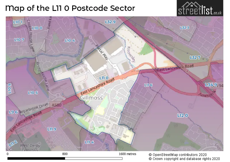
Map of the L11 0 Postcode Sector
Explore the L11 0 postcode sector by using our free interactive map.
| L | 1 | 1 | - | 0 | X | X |
| L | 1 | 1 | Space | 0 | Letter | Letter |
Official List of Streets
LIVERPOOL (30 Streets)
Gilmoss Industrial Estate (3 Streets)
West Derby (1 Streets)
Croxteth (1 Streets)
Unofficial Streets or Alternative Spellings
Weather Forecast for L11 0
Press Button to Show Forecast for Fazakerley
| Time Period | Icon | Description | Temperature | Rain Probability | Wind |
|---|---|---|---|---|---|
| 00:00 to 03:00 | Cloudy | 11.0°C (feels like 8.0°C) | 9.00% | SSE 13 mph | |
| 03:00 to 06:00 | Cloudy | 10.0°C (feels like 7.0°C) | 7.00% | SE 16 mph | |
| 06:00 to 09:00 | Cloudy | 10.0°C (feels like 7.0°C) | 4.00% | SE 16 mph | |
| 09:00 to 12:00 | Cloudy | 12.0°C (feels like 9.0°C) | 5.00% | SE 18 mph | |
| 12:00 to 15:00 | Cloudy | 15.0°C (feels like 11.0°C) | 8.00% | SSE 18 mph | |
| 15:00 to 18:00 | Cloudy | 15.0°C (feels like 12.0°C) | 14.00% | SSE 16 mph | |
| 18:00 to 21:00 | Cloudy | 13.0°C (feels like 11.0°C) | 15.00% | SSE 11 mph | |
| 21:00 to 00:00 | Overcast | 12.0°C (feels like 10.0°C) | 15.00% | SE 9 mph |
Press Button to Show Forecast for Fazakerley
| Time Period | Icon | Description | Temperature | Rain Probability | Wind |
|---|---|---|---|---|---|
| 00:00 to 03:00 | Cloudy | 11.0°C (feels like 9.0°C) | 9.00% | SE 9 mph | |
| 03:00 to 06:00 | Cloudy | 10.0°C (feels like 8.0°C) | 5.00% | SE 7 mph | |
| 06:00 to 09:00 | Cloudy | 9.0°C (feels like 8.0°C) | 4.00% | SE 7 mph | |
| 09:00 to 12:00 | Cloudy | 12.0°C (feels like 10.0°C) | 5.00% | ESE 7 mph | |
| 12:00 to 15:00 | Cloudy | 14.0°C (feels like 13.0°C) | 7.00% | SSE 7 mph | |
| 15:00 to 18:00 | Cloudy | 15.0°C (feels like 14.0°C) | 10.00% | NW 7 mph | |
| 18:00 to 21:00 | Cloudy | 14.0°C (feels like 12.0°C) | 11.00% | NW 7 mph | |
| 21:00 to 00:00 | Cloudy | 12.0°C (feels like 11.0°C) | 10.00% | NNW 9 mph |
Press Button to Show Forecast for Fazakerley
| Time Period | Icon | Description | Temperature | Rain Probability | Wind |
|---|---|---|---|---|---|
| 00:00 to 03:00 | Cloudy | 11.0°C (feels like 10.0°C) | 11.00% | N 9 mph | |
| 03:00 to 06:00 | Cloudy | 11.0°C (feels like 9.0°C) | 8.00% | N 7 mph | |
| 06:00 to 09:00 | Cloudy | 11.0°C (feels like 10.0°C) | 6.00% | N 7 mph | |
| 09:00 to 12:00 | Partly cloudy (day) | 13.0°C (feels like 11.0°C) | 4.00% | N 9 mph | |
| 12:00 to 15:00 | Sunny day | 15.0°C (feels like 14.0°C) | 3.00% | NNE 11 mph | |
| 15:00 to 18:00 | Partly cloudy (day) | 17.0°C (feels like 14.0°C) | 3.00% | N 11 mph | |
| 18:00 to 21:00 | Sunny day | 16.0°C (feels like 13.0°C) | 3.00% | N 11 mph | |
| 21:00 to 00:00 | Clear night | 13.0°C (feels like 11.0°C) | 3.00% | NNE 11 mph |
Schools and Places of Education Within the L11 0 Postcode Sector
Croxteth Community Primary School
Academy sponsor led
Moss Way, Liverpool, , L11 0BP
Head: Miss Lottie Harriman
Ofsted Rating: Good
Inspection: 2023-06-21 (314 days ago)
Website: Visit Croxteth Community Primary School Website
Phone: 01515463140
Number of Pupils: 298
Our Lady and St Swithin's Catholic Primary School
Voluntary aided school
Parkstile Lane, Merseyside, Merseyside, L11 0BQ
Head: Mrs Emma Hartley
Ofsted Rating: Good
Inspection: 2023-02-09 (446 days ago)
Website: Visit Our Lady and St Swithin's Catholic Primary School Website
Phone: 01515463868
Number of Pupils: 235
House Prices in the L11 0 Postcode Sector
| Type of Property | 2018 Average | 2018 Sales | 2017 Average | 2017 Sales | 2016 Average | 2016 Sales | 2015 Average | 2015 Sales |
|---|---|---|---|---|---|---|---|---|
| Detached | £0 | 0 | £160,000 | 1 | £0 | 0 | £0 | 0 |
| Semi-Detached | £71,500 | 2 | £85,000 | 1 | £75,000 | 3 | £83,250 | 4 |
| Terraced | £77,600 | 5 | £76,833 | 6 | £76,488 | 8 | £68,590 | 5 |
| Flats | £70,000 | 1 | £70,000 | 1 | £0 | 0 | £0 | 0 |
Important Postcodes L11 0 in the Postcode Sector
L11 0AG is the postcode for Gillmoss Medical Centre, 48 Petherick Road
L11 0BP is the postcode for Croxteth Cp School, Moss Way
L11 0BQ is the postcode for Our Lady & St. Swithins Primary School, Parkstile Lane
L11 0BS is the postcode for Croxteth Family Health Clinic, Altcross Road, and Croxteth Sports Centre & Croxteth Library, Altcross Road
| The L11 0 Sector is within these Local Authorities |
|
|---|---|
| The L11 0 Sector is within these Counties |
|
| The L11 0 Sector is within these Water Company Areas |
|