The L14 3 postcode sector is within the county of Merseyside.
Did you know? According to the 2021 Census, the L14 3 postcode sector is home to a bustling 1,888 residents!
Given that each sector allows for 400 unique postcode combinations. Letters C, I, K, M, O and V are not allowed in the last two letters of a postcode. With 35 postcodes already in use, this leaves 365 units available.
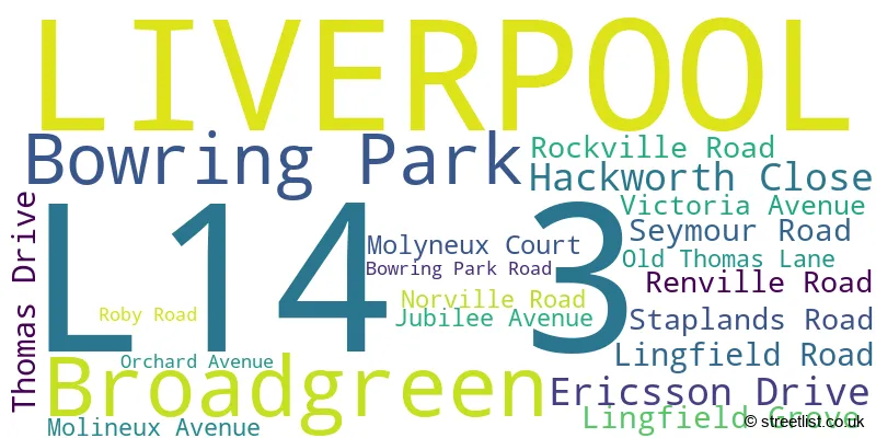
The largest settlement in the L14 3 postal code is LIVERPOOL followed by Broadgreen, and Bowring Park.
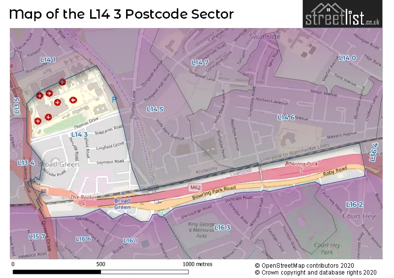
The L14 3 Postcode shares a border with L14 1 (LIVERPOOL), L13 4 (LIVERPOOL, Old Swan, Stoneycroft), L13 5 (LIVERPOOL, Old Swan, Stoneycroft), L15 7 (LIVERPOOL, Wavertree), L16 1 (LIVERPOOL, Childwall), L16 6 (LIVERPOOL, Childwall), L14 5 (LIVERPOOL), L14 6 (LIVERPOOL, Broadgreen, Bowring Park), L16 2 (LIVERPOOL, Broadgreen), L16 3 (LIVERPOOL) and L36 4 (LIVERPOOL, Huyton).
The sector is within the post town of LIVERPOOL.
L14 3 is a postcode sector within the L1 postcode district which is within the L Liverpool postcode area.
The Royal Mail delivery office for the L14 3 postal sector is the Liverpool 1-3.
The area of the L14 3 postcode sector is 0.24 square miles which is 0.62 square kilometres or 154.24 square acres.

Map of the L14 3 Postcode Sector
Explore the L14 3 postcode sector by using our free interactive map.
| L | 1 | 4 | - | 3 | X | X |
| L | 1 | 4 | Space | 3 | Letter | Letter |
Official List of Streets
LIVERPOOL (15 Streets)
Broadgreen (2 Streets)
Unofficial Streets or Alternative Spellings
Mossley Hill
QUEENS DRIVELIVERPOOL
BOWRING PARK AVENUE BROAD GREEN ROAD CHELWOOD AVENUE COURT HEY ROAD EDGE LANE DRIVE GLENEAGLES ROAD GRANGEWOOD RIMMER AVENUE THOMAS LANE WILLINGDON ROADChildwall
ROCKY LANE ALEXANDRA ROAD EAST ROAD ELOWEN CLOSE LIVERPOOL LOOP LINE NORTH ROAD QUEENS DRIVE STONEYCROFT SOUTH ROAD WALSH ROAD WEST ROADWeather Forecast for L14 3
Press Button to Show Forecast for Knotty Ash
| Time Period | Icon | Description | Temperature | Rain Probability | Wind |
|---|---|---|---|---|---|
| 06:00 to 09:00 | Cloudy | 10.0°C (feels like 6.0°C) | 5.00% | SE 16 mph | |
| 09:00 to 12:00 | Cloudy | 12.0°C (feels like 8.0°C) | 8.00% | SE 18 mph | |
| 12:00 to 15:00 | Cloudy | 14.0°C (feels like 11.0°C) | 9.00% | SSE 18 mph | |
| 15:00 to 18:00 | Cloudy | 15.0°C (feels like 12.0°C) | 15.00% | SSE 16 mph | |
| 18:00 to 21:00 | Light rain shower (day) | 13.0°C (feels like 11.0°C) | 35.00% | SSE 11 mph | |
| 21:00 to 00:00 | Cloudy | 11.0°C (feels like 10.0°C) | 16.00% | SE 9 mph |
Press Button to Show Forecast for Knotty Ash
| Time Period | Icon | Description | Temperature | Rain Probability | Wind |
|---|---|---|---|---|---|
| 00:00 to 03:00 | Cloudy | 10.0°C (feels like 9.0°C) | 8.00% | SE 7 mph | |
| 03:00 to 06:00 | Cloudy | 9.0°C (feels like 8.0°C) | 4.00% | SE 7 mph | |
| 06:00 to 09:00 | Cloudy | 9.0°C (feels like 7.0°C) | 4.00% | SE 7 mph | |
| 09:00 to 12:00 | Cloudy | 11.0°C (feels like 10.0°C) | 5.00% | ESE 7 mph | |
| 12:00 to 15:00 | Cloudy | 14.0°C (feels like 13.0°C) | 8.00% | SE 7 mph | |
| 15:00 to 18:00 | Cloudy | 15.0°C (feels like 14.0°C) | 13.00% | SSE 7 mph | |
| 18:00 to 21:00 | Cloudy | 14.0°C (feels like 13.0°C) | 12.00% | WNW 7 mph | |
| 21:00 to 00:00 | Cloudy | 13.0°C (feels like 12.0°C) | 11.00% | NW 7 mph |
Press Button to Show Forecast for Knotty Ash
| Time Period | Icon | Description | Temperature | Rain Probability | Wind |
|---|---|---|---|---|---|
| 00:00 to 03:00 | Cloudy | 12.0°C (feels like 10.0°C) | 12.00% | NNW 7 mph | |
| 03:00 to 06:00 | Cloudy | 11.0°C (feels like 10.0°C) | 9.00% | NNW 7 mph | |
| 06:00 to 09:00 | Cloudy | 11.0°C (feels like 10.0°C) | 7.00% | NNW 7 mph | |
| 09:00 to 12:00 | Partly cloudy (day) | 13.0°C (feels like 11.0°C) | 5.00% | N 9 mph | |
| 12:00 to 15:00 | Sunny day | 16.0°C (feels like 14.0°C) | 5.00% | N 9 mph | |
| 15:00 to 18:00 | Sunny day | 17.0°C (feels like 15.0°C) | 3.00% | N 11 mph | |
| 18:00 to 21:00 | Sunny day | 17.0°C (feels like 14.0°C) | 4.00% | N 11 mph | |
| 21:00 to 00:00 | Clear night | 14.0°C (feels like 12.0°C) | 3.00% | NNE 9 mph |
House Prices in the L14 3 Postcode Sector
| Type of Property | 2018 Average | 2018 Sales | 2017 Average | 2017 Sales | 2016 Average | 2016 Sales | 2015 Average | 2015 Sales |
|---|---|---|---|---|---|---|---|---|
| Detached | £204,998 | 3 | £234,825 | 6 | £219,896 | 15 | £209,229 | 27 |
| Semi-Detached | £170,909 | 17 | £167,776 | 17 | £158,226 | 22 | £159,949 | 36 |
| Terraced | £143,417 | 6 | £125,838 | 8 | £132,750 | 2 | £138,083 | 6 |
| Flats | £0 | 0 | £88,250 | 2 | £97,667 | 3 | £0 | 0 |
Important Postcodes L14 3 in the Postcode Sector
L14 3LB is the postcode for Royal Liverpool and Broadgreen University Hospitals NHS Trust, Thomas Drive, BLOCK C EAST ROAD, BROADGREEN HOSPITAL, THOMAS DRIVE, Broadgreen Hospital NHS Trust, Thomas Drive, ALEXANDRA WING, BROADGREEN HOSPITAL, THOMAS DRIVE, and SURGICAL CORRIDOR WEST ROAD, BROADGREEN HOSPITAL, THOMAS DRIVE
L14 3NZ is the postcode for Parcelforce Worldwide, Unit K-l, Bowring Park Road, Rocket Trading Centre
L14 3PE is the postcode for EXECUTIVE BLOCK, Liverpool Heart and Chest Hospital, Thomas Drive, SURGICAL CORRIDOR, Royal Liverpool Hospital, Thomas Drive, EXISTING OLD BUILDINGS, Liverpool Heart and Chest Hospital, Thomas Drive, BLOCK C, BROADGREEN HOSPITAL, THOMAS DRIVE, EXISTING BUILDING, Liverpool Heart and Chest Hospital, Thomas Drive, SURGICAL CORRIDOR, BROADGREEN HOSPITAL, THOMAS DRIVE, BLOCK C, Royal Liverpool Hospital, Thomas Drive, MORONEY HOUSE, Liverpool Heart and Chest Hospital, Thomas Drive, HIGHFIELD HOUSE, Liverpool Heart and Chest Hospital, Thomas Drive, ALEXANDRA WING, BROADGREEN HOSPITAL, THOMAS DRIVE, ROBERT OWEN HOUSE, Liverpool Heart and Chest Hospital, Thomas Drive, ALEXANDRA WING, Royal Liverpool Hospital, Thomas Drive, BLOCKS A, B AND D, Liverpool Heart and Chest Hospital, Thomas Drive, and The Cardiothoracic Centre - Liverpool NHS Trust, The Cardiothoracic Centre
L14 3PJ is the postcode for Mersey Care NHS Trust, Broad Oak Unit (Broadgreen Hospital Site), and Broadoak Unit, Thomas Drive
| The L14 3 Sector is within these Local Authorities |
|
|---|---|
| The L14 3 Sector is within these Counties |
|
| The L14 3 Sector is within these Water Company Areas |
|