The L17 0 postcode sector is within the county of Merseyside.
Did you know? According to the 2021 Census, the L17 0 postcode sector is home to a bustling 4,026 residents!
Given that each sector allows for 400 unique postcode combinations. Letters C, I, K, M, O and V are not allowed in the last two letters of a postcode. With 72 postcodes already in use, this leaves 328 units available.
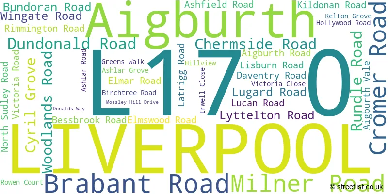
The largest settlements in the L17 0 postal code are LIVERPOOL and Aigburth.
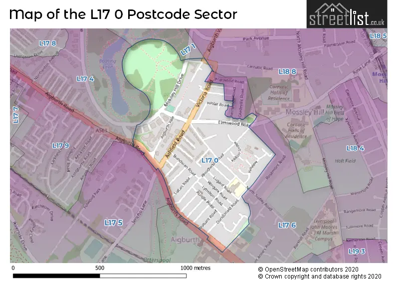
The L17 0 Postcode shares a border with L17 1 (LIVERPOOL, Sefton Park), L17 4 (LIVERPOOL, Aigburth), L17 5 (LIVERPOOL), L17 6 (LIVERPOOL, Aigburth) and L18 8 (LIVERPOOL, Mossley Hill).
The sector is within the post town of LIVERPOOL.
L17 0 is a postcode sector within the L1 postcode district which is within the L Liverpool postcode area.
The Royal Mail delivery office for the L17 0 postal sector is the Liverpool 1-3.
The area of the L17 0 postcode sector is 0.22 square miles which is 0.57 square kilometres or 141.00 square acres.

Map of the L17 0 Postcode Sector
Explore the L17 0 postcode sector by using our free interactive map.
| L | 1 | 7 | - | 0 | X | X |
| L | 1 | 7 | Space | 0 | Letter | Letter |
Official List of Streets
LIVERPOOL (34 Streets)
Unofficial Streets or Alternative Spellings
Mossley Hill
CARNATIC ROADLIVERPOOL
FERNWOOD ROAD GLADEVILLE ROAD IRWELL LANE LYTTLETON ROAD ROWAN COURTWeather Forecast for L17 0
Press Button to Show Forecast for Grassendale
| Time Period | Icon | Description | Temperature | Rain Probability | Wind |
|---|---|---|---|---|---|
| 03:00 to 06:00 | Cloudy | 10.0°C (feels like 7.0°C) | 5.00% | SE 16 mph | |
| 06:00 to 09:00 | Cloudy | 10.0°C (feels like 6.0°C) | 5.00% | SE 18 mph | |
| 09:00 to 12:00 | Cloudy | 12.0°C (feels like 8.0°C) | 8.00% | SE 18 mph | |
| 12:00 to 15:00 | Cloudy | 15.0°C (feels like 11.0°C) | 9.00% | SSE 18 mph | |
| 15:00 to 18:00 | Cloudy | 15.0°C (feels like 11.0°C) | 15.00% | SSE 16 mph | |
| 18:00 to 21:00 | Light rain shower (day) | 13.0°C (feels like 11.0°C) | 35.00% | SSE 11 mph | |
| 21:00 to 00:00 | Overcast | 11.0°C (feels like 10.0°C) | 16.00% | SE 9 mph |
Press Button to Show Forecast for Grassendale
| Time Period | Icon | Description | Temperature | Rain Probability | Wind |
|---|---|---|---|---|---|
| 00:00 to 03:00 | Cloudy | 10.0°C (feels like 9.0°C) | 7.00% | SE 9 mph | |
| 03:00 to 06:00 | Cloudy | 9.0°C (feels like 8.0°C) | 4.00% | SE 7 mph | |
| 06:00 to 09:00 | Cloudy | 9.0°C (feels like 7.0°C) | 4.00% | SE 7 mph | |
| 09:00 to 12:00 | Cloudy | 12.0°C (feels like 10.0°C) | 5.00% | ESE 7 mph | |
| 12:00 to 15:00 | Cloudy | 14.0°C (feels like 13.0°C) | 8.00% | SE 7 mph | |
| 15:00 to 18:00 | Cloudy | 15.0°C (feels like 14.0°C) | 13.00% | SSE 7 mph | |
| 18:00 to 21:00 | Cloudy | 15.0°C (feels like 13.0°C) | 12.00% | WNW 7 mph | |
| 21:00 to 00:00 | Cloudy | 13.0°C (feels like 12.0°C) | 11.00% | WNW 7 mph |
Press Button to Show Forecast for Grassendale
| Time Period | Icon | Description | Temperature | Rain Probability | Wind |
|---|---|---|---|---|---|
| 00:00 to 03:00 | Cloudy | 12.0°C (feels like 10.0°C) | 12.00% | N 7 mph | |
| 03:00 to 06:00 | Cloudy | 11.0°C (feels like 10.0°C) | 9.00% | NNW 7 mph | |
| 06:00 to 09:00 | Cloudy | 11.0°C (feels like 10.0°C) | 7.00% | NNW 7 mph | |
| 09:00 to 12:00 | Cloudy | 13.0°C (feels like 12.0°C) | 8.00% | N 9 mph | |
| 12:00 to 15:00 | Sunny day | 16.0°C (feels like 14.0°C) | 5.00% | N 9 mph | |
| 15:00 to 18:00 | Sunny day | 18.0°C (feels like 15.0°C) | 3.00% | N 11 mph | |
| 18:00 to 21:00 | Sunny day | 17.0°C (feels like 14.0°C) | 4.00% | N 11 mph | |
| 21:00 to 00:00 | Clear night | 14.0°C (feels like 12.0°C) | 3.00% | NNE 9 mph |
House Prices in the L17 0 Postcode Sector
| Type of Property | 2018 Average | 2018 Sales | 2017 Average | 2017 Sales | 2016 Average | 2016 Sales | 2015 Average | 2015 Sales |
|---|---|---|---|---|---|---|---|---|
| Detached | £245,000 | 1 | £0 | 0 | £310,000 | 1 | £235,000 | 1 |
| Semi-Detached | £279,246 | 12 | £269,380 | 19 | £238,917 | 12 | £222,695 | 10 |
| Terraced | £212,785 | 62 | £187,125 | 52 | £166,042 | 42 | £169,171 | 52 |
| Flats | £196,625 | 20 | £176,341 | 16 | £178,165 | 26 | £157,869 | 31 |
Important Postcodes L17 0 in the Postcode Sector
L17 0AE is the postcode for Sudley Infant School, 63 Dundonald Road
| The L17 0 Sector is within these Local Authorities |
|
|---|---|
| The L17 0 Sector is within these Counties |
|
| The L17 0 Sector is within these Water Company Areas |
|