The L11 2 postcode sector is within the county of Merseyside.
Did you know? According to the 2021 Census, the L11 2 postcode sector is home to a bustling 5,816 residents!
Given that each sector allows for 400 unique postcode combinations. Letters C, I, K, M, O and V are not allowed in the last two letters of a postcode. With 97 postcodes already in use, this leaves 303 units available.
The largest settlements in the L11 2 postal code are LIVERPOOL and West Derby.
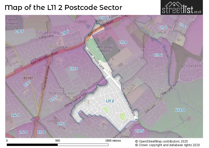
The L11 2 Postcode shares a border with L9 6 (LIVERPOOL, Walton), L11 1 (LIVERPOOL, Norris Green), L11 3 (LIVERPOOL), L11 4 (LIVERPOOL, Croxteth), L11 9 (LIVERPOOL, Croxteth) and L12 0 (LIVERPOOL, West Derby).
The sector is within the post town of LIVERPOOL.
L11 2 is a postcode sector within the L11 postcode district which is within the L Liverpool postcode area.
The Royal Mail delivery office for the L11 2 postal sector is the West Derby Delivery Office.
The area of the L11 2 postcode sector is 0.30 square miles which is 0.79 square kilometres or 194.94 square acres.

Map of the L11 2 Postcode Sector
Explore the L11 2 postcode sector by using our free interactive map.
| L | 1 | 1 | - | 2 | X | X |
| L | 1 | 1 | Space | 2 | Letter | Letter |
Official List of Streets
LIVERPOOL (62 Streets)
Unofficial Streets or Alternative Spellings
Glazebury
EAST LANCASHIRE ROADLIVERPOOL
BRAYBROOKE ROAD CANELLA AVENUE CARR LANE EAST COTTESBROOK ROAD ELDERFLOWER DRIVE FIELDTON ROAD LEWISHAM ROAD LOWER LANE MUIRHEAD AVENUE EAST PARSLEY WAY STORRINGTON AVENUE TAMARIND DRIVE UTTING AVENUE EAST WANDSWORTH ROAD WINTERGREEN AVENUE OAK LANE SORRELL AVENUEWeather Forecast for L11 2
Press Button to Show Forecast for Fazakerley
| Time Period | Icon | Description | Temperature | Rain Probability | Wind |
|---|---|---|---|---|---|
| 21:00 to 00:00 | Cloudy | 7.0°C (feels like 5.0°C) | 8.00% | E 9 mph |
Press Button to Show Forecast for Fazakerley
| Time Period | Icon | Description | Temperature | Rain Probability | Wind |
|---|---|---|---|---|---|
| 00:00 to 03:00 | Cloudy | 6.0°C (feels like 4.0°C) | 5.00% | E 7 mph | |
| 03:00 to 06:00 | Partly cloudy (night) | 5.0°C (feels like 3.0°C) | 2.00% | ENE 7 mph | |
| 06:00 to 09:00 | Partly cloudy (day) | 5.0°C (feels like 3.0°C) | 2.00% | E 7 mph | |
| 09:00 to 12:00 | Cloudy | 8.0°C (feels like 6.0°C) | 5.00% | E 9 mph | |
| 12:00 to 15:00 | Overcast | 10.0°C (feels like 8.0°C) | 10.00% | E 9 mph | |
| 15:00 to 18:00 | Overcast | 10.0°C (feels like 8.0°C) | 46.00% | ENE 9 mph | |
| 18:00 to 21:00 | Overcast | 9.0°C (feels like 7.0°C) | 9.00% | NE 9 mph | |
| 21:00 to 00:00 | Cloudy | 8.0°C (feels like 6.0°C) | 8.00% | NE 9 mph |
Press Button to Show Forecast for Fazakerley
| Time Period | Icon | Description | Temperature | Rain Probability | Wind |
|---|---|---|---|---|---|
| 00:00 to 03:00 | Partly cloudy (night) | 6.0°C (feels like 4.0°C) | 2.00% | NNE 7 mph | |
| 03:00 to 06:00 | Cloudy | 6.0°C (feels like 3.0°C) | 4.00% | NNE 9 mph | |
| 06:00 to 09:00 | Cloudy | 6.0°C (feels like 3.0°C) | 8.00% | N 9 mph | |
| 09:00 to 12:00 | Cloudy | 8.0°C (feels like 5.0°C) | 10.00% | NNW 11 mph | |
| 12:00 to 15:00 | Partly cloudy (day) | 9.0°C (feels like 7.0°C) | 8.00% | NW 11 mph | |
| 15:00 to 18:00 | Sunny day | 10.0°C (feels like 7.0°C) | 7.00% | WNW 13 mph | |
| 18:00 to 21:00 | Sunny day | 10.0°C (feels like 8.0°C) | 4.00% | W 11 mph | |
| 21:00 to 00:00 | Clear night | 9.0°C (feels like 6.0°C) | 2.00% | SW 11 mph |
Press Button to Show Forecast for Fazakerley
| Time Period | Icon | Description | Temperature | Rain Probability | Wind |
|---|---|---|---|---|---|
| 00:00 to 03:00 | Clear night | 8.0°C (feels like 5.0°C) | 1.00% | SSW 9 mph | |
| 03:00 to 06:00 | Cloudy | 7.0°C (feels like 4.0°C) | 6.00% | S 11 mph | |
| 06:00 to 09:00 | Cloudy | 7.0°C (feels like 4.0°C) | 10.00% | SSE 11 mph | |
| 09:00 to 12:00 | Partly cloudy (day) | 10.0°C (feels like 7.0°C) | 2.00% | SSE 13 mph | |
| 12:00 to 15:00 | Cloudy | 13.0°C (feels like 10.0°C) | 8.00% | S 16 mph | |
| 15:00 to 18:00 | Overcast | 13.0°C (feels like 10.0°C) | 13.00% | S 16 mph | |
| 18:00 to 21:00 | Cloudy | 13.0°C (feels like 10.0°C) | 10.00% | SSE 16 mph | |
| 21:00 to 00:00 | Partly cloudy (night) | 11.0°C (feels like 9.0°C) | 3.00% | SSE 13 mph |
Press Button to Show Forecast for Fazakerley
| Time Period | Icon | Description | Temperature | Rain Probability | Wind |
|---|---|---|---|---|---|
| 00:00 to 03:00 | Partly cloudy (night) | 10.0°C (feels like 7.0°C) | 4.00% | SE 13 mph | |
| 03:00 to 06:00 | Cloudy | 9.0°C (feels like 6.0°C) | 7.00% | SE 13 mph | |
| 06:00 to 09:00 | Cloudy | 9.0°C (feels like 6.0°C) | 6.00% | SE 13 mph | |
| 09:00 to 12:00 | Partly cloudy (day) | 12.0°C (feels like 9.0°C) | 4.00% | SE 13 mph | |
| 12:00 to 15:00 | Partly cloudy (day) | 15.0°C (feels like 12.0°C) | 5.00% | SE 16 mph | |
| 15:00 to 18:00 | Cloudy | 16.0°C (feels like 13.0°C) | 11.00% | SE 13 mph | |
| 18:00 to 21:00 | Partly cloudy (day) | 15.0°C (feels like 13.0°C) | 6.00% | SE 11 mph | |
| 21:00 to 00:00 | Cloudy | 13.0°C (feels like 11.0°C) | 7.00% | ESE 11 mph |
Schools and Places of Education Within the L11 2 Postcode Sector
Ellergreen Nursery School and Childcare Centre
Local authority nursery school
Ellergreen Road, Liverpool, Merseyside, L11 2RY
Head: Mrs Jane Rogers
Ofsted Rating: Outstanding
Inspection: 2020-01-09 (1569 days ago)
Website: Visit Ellergreen Nursery School and Childcare Centre Website
Phone: 01512334594
Number of Pupils: 169
House Prices in the L11 2 Postcode Sector
| Type of Property | 2018 Average | 2018 Sales | 2017 Average | 2017 Sales | 2016 Average | 2016 Sales | 2015 Average | 2015 Sales |
|---|---|---|---|---|---|---|---|---|
| Detached | £187,848 | 17 | £168,300 | 3 | £143,998 | 2 | £152,391 | 23 |
| Semi-Detached | £145,752 | 43 | £91,071 | 7 | £123,944 | 9 | £124,933 | 50 |
| Terraced | £74,215 | 19 | £63,423 | 20 | £70,000 | 7 | £54,134 | 16 |
| Flats | £97,748 | 2 | £68,000 | 2 | £61,500 | 2 | £113,375 | 4 |
Important Postcodes L11 2 in the Postcode Sector
L11 2RY is the postcode for Ellergreen Childcare Centre, Ellergreen Road, and Ellergreen Community & Early Years Centre, Ellergreen Road
L11 2XZ is the postcode for Lifestyles Ellergreen, Carr Lane, West Derby, and Lifestyles Ellergreen, Carr Lane
L11 2YA is the postcode for Medical Centre, 24 Carr Lane
| The L11 2 Sector is within these Local Authorities |
|
|---|---|
| The L11 2 Sector is within these Counties |
|
| The L11 2 Sector is within these Water Company Areas |
|