The L15 9 postcode sector is within the county of Merseyside.
Did you know? According to the 2021 Census, the L15 9 postcode sector is home to a bustling 1,631 residents!
Given that each sector allows for 400 unique postcode combinations. Letters C, I, K, M, O and V are not allowed in the last two letters of a postcode. With 33 postcodes already in use, this leaves 367 units available.
The largest settlements in the L15 9 postal code are LIVERPOOL and Wavertree.
The L15 9 Postcode shares a border with L18 0 (LIVERPOOL, Mossley Hill), L18 1 (LIVERPOOL, Mossley Hill), L15 6 (LIVERPOOL, Wavertree) and L15 5 (LIVERPOOL, Wavertree).
The sector is within the post town of LIVERPOOL.
L15 9 is a postcode sector within the L15 postcode district which is within the L Liverpool postcode area.
The Royal Mail delivery office for the L15 9 postal sector is the South Eastern (l) Delivery Office.
The area of the L15 9 postcode sector is 0.08 square miles which is 0.20 square kilometres or 50.41 square acres.

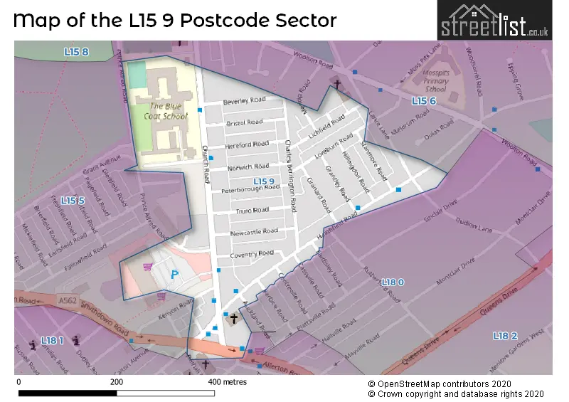
Map of the L15 9 Postcode Sector
Explore the L15 9 postcode sector by using our free interactive map.
| L | 1 | 5 | - | 9 | X | X |
| L | 1 | 5 | Space | 9 | Letter | Letter |
Official List of Streets
LIVERPOOL (16 Streets)
Unofficial Streets or Alternative Spellings
Weather Forecast for L15 9
Press Button to Show Forecast for Wavertree
| Time Period | Icon | Description | Temperature | Rain Probability | Wind |
|---|---|---|---|---|---|
| 09:00 to 12:00 | Cloudy | 8.0°C (feels like 6.0°C) | 5.00% | E 9 mph | |
| 12:00 to 15:00 | Overcast | 10.0°C (feels like 8.0°C) | 9.00% | E 9 mph | |
| 15:00 to 18:00 | Overcast | 10.0°C (feels like 8.0°C) | 46.00% | ENE 9 mph | |
| 18:00 to 21:00 | Overcast | 9.0°C (feels like 7.0°C) | 45.00% | NE 9 mph | |
| 21:00 to 00:00 | Cloudy | 8.0°C (feels like 6.0°C) | 5.00% | NE 9 mph |
Press Button to Show Forecast for Wavertree
| Time Period | Icon | Description | Temperature | Rain Probability | Wind |
|---|---|---|---|---|---|
| 00:00 to 03:00 | Partly cloudy (night) | 7.0°C (feels like 4.0°C) | 2.00% | NE 7 mph | |
| 03:00 to 06:00 | Cloudy | 6.0°C (feels like 3.0°C) | 4.00% | NNE 9 mph | |
| 06:00 to 09:00 | Cloudy | 6.0°C (feels like 3.0°C) | 8.00% | N 9 mph | |
| 09:00 to 12:00 | Cloudy | 8.0°C (feels like 5.0°C) | 10.00% | NNW 9 mph | |
| 12:00 to 15:00 | Cloudy | 9.0°C (feels like 7.0°C) | 12.00% | NW 11 mph | |
| 15:00 to 18:00 | Sunny day | 10.0°C (feels like 7.0°C) | 8.00% | WNW 13 mph | |
| 18:00 to 21:00 | Sunny day | 10.0°C (feels like 8.0°C) | 3.00% | W 11 mph | |
| 21:00 to 00:00 | Clear night | 9.0°C (feels like 6.0°C) | 2.00% | SW 11 mph |
Press Button to Show Forecast for Wavertree
| Time Period | Icon | Description | Temperature | Rain Probability | Wind |
|---|---|---|---|---|---|
| 00:00 to 03:00 | Clear night | 8.0°C (feels like 5.0°C) | 1.00% | SSW 9 mph | |
| 03:00 to 06:00 | Cloudy | 7.0°C (feels like 4.0°C) | 5.00% | S 11 mph | |
| 06:00 to 09:00 | Cloudy | 7.0°C (feels like 3.0°C) | 7.00% | SSE 11 mph | |
| 09:00 to 12:00 | Partly cloudy (day) | 10.0°C (feels like 7.0°C) | 2.00% | SSE 13 mph | |
| 12:00 to 15:00 | Overcast | 13.0°C (feels like 10.0°C) | 10.00% | S 16 mph | |
| 15:00 to 18:00 | Cloudy | 13.0°C (feels like 10.0°C) | 9.00% | S 16 mph | |
| 18:00 to 21:00 | Cloudy | 13.0°C (feels like 10.0°C) | 8.00% | SSE 16 mph | |
| 21:00 to 00:00 | Partly cloudy (night) | 11.0°C (feels like 8.0°C) | 3.00% | SSE 13 mph |
Press Button to Show Forecast for Wavertree
| Time Period | Icon | Description | Temperature | Rain Probability | Wind |
|---|---|---|---|---|---|
| 00:00 to 03:00 | Partly cloudy (night) | 10.0°C (feels like 7.0°C) | 4.00% | SE 13 mph | |
| 03:00 to 06:00 | Cloudy | 9.0°C (feels like 6.0°C) | 6.00% | SE 13 mph | |
| 06:00 to 09:00 | Cloudy | 9.0°C (feels like 6.0°C) | 6.00% | SE 13 mph | |
| 09:00 to 12:00 | Cloudy | 12.0°C (feels like 9.0°C) | 7.00% | SE 13 mph | |
| 12:00 to 15:00 | Partly cloudy (day) | 15.0°C (feels like 11.0°C) | 5.00% | SE 16 mph | |
| 15:00 to 18:00 | Cloudy | 16.0°C (feels like 13.0°C) | 14.00% | SE 13 mph | |
| 18:00 to 21:00 | Partly cloudy (day) | 15.0°C (feels like 13.0°C) | 6.00% | SE 11 mph | |
| 21:00 to 00:00 | Cloudy | 13.0°C (feels like 11.0°C) | 8.00% | E 9 mph |
Schools and Places of Education Within the L15 9 Postcode Sector
The Blue Coat School
Academy converter
Church Road, Liverpool, Merseyside, L15 9EE
Head: Mrs Scilla Yates
Ofsted Rating: Good
Inspection: 2022-11-09 (535 days ago)
Website: Visit The Blue Coat School Website
Phone: 01517331407
Number of Pupils: 1246
House Prices in the L15 9 Postcode Sector
| Type of Property | 2018 Average | 2018 Sales | 2017 Average | 2017 Sales | 2016 Average | 2016 Sales | 2015 Average | 2015 Sales |
|---|---|---|---|---|---|---|---|---|
| Detached | £230,000 | 1 | £0 | 0 | £0 | 0 | £0 | 0 |
| Semi-Detached | £206,750 | 8 | £196,080 | 5 | £228,417 | 6 | £208,169 | 9 |
| Terraced | £213,775 | 18 | £182,563 | 16 | £198,120 | 30 | £197,519 | 34 |
| Flats | £159,000 | 2 | £86,450 | 1 | £95,100 | 8 | £0 | 0 |
Important Postcodes L15 9 in the Postcode Sector
L15 9EE is the postcode for THE BLUE COAT SCHOOL, CHURCH ROAD, WAVERTREE, and The Blue Coat School, Church Road
L15 9EH is the postcode for Penny Lane Surgery, 7 Smithdown Place
| The L15 9 Sector is within these Local Authorities |
|
|---|---|
| The L15 9 Sector is within these Counties |
|
| The L15 9 Sector is within these Water Company Areas |
|