The L21 9 postcode sector is within the county of Merseyside.
Did you know? According to the 2021 Census, the L21 9 postcode sector is home to a bustling 5,243 residents!
Given that each sector allows for 400 unique postcode combinations. Letters C, I, K, M, O and V are not allowed in the last two letters of a postcode. With 91 postcodes already in use, this leaves 309 units available.
The largest settlements in the L21 9 postal code are LIVERPOOL and Litherland.
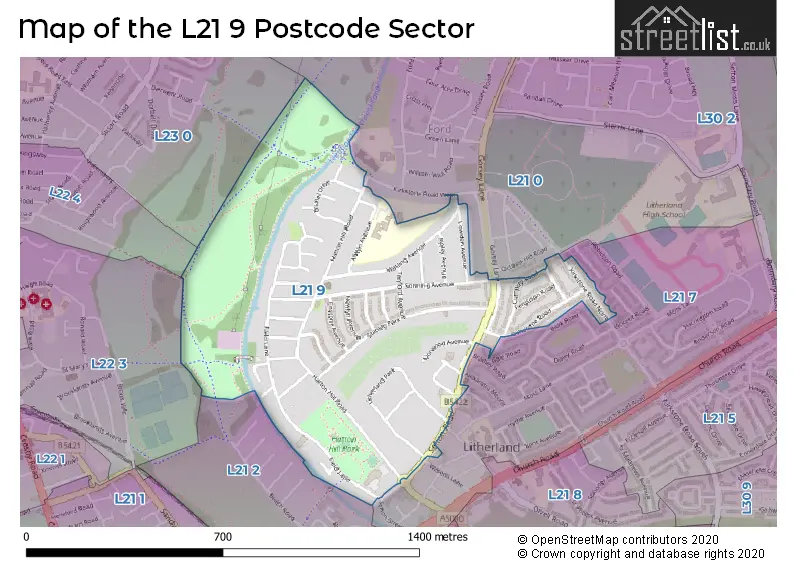
The L21 9 Postcode shares a border with L22 3 (LIVERPOOL, Waterloo), L22 4 (LIVERPOOL, Waterloo), L21 0 (LIVERPOOL, Ford), L21 2 (LIVERPOOL, Litherland), L21 7 (LIVERPOOL, Litherland) and L23 0 (LIVERPOOL, Crosby, Great Crosby).
The sector is within the post town of LIVERPOOL.
L21 9 is a postcode sector within the L2 postcode district which is within the L Liverpool postcode area.
The Royal Mail delivery office for the L21 9 postal sector is the Liverpool 1-3.
The area of the L21 9 postcode sector is 0.41 square miles which is 1.07 square kilometres or 265.50 square acres.
Waterways within the L21 9 postcode sector include the Leeds and Liverpool Canal.

Map of the L21 9 Postcode Sector
Explore the L21 9 postcode sector by using our free interactive map.
| L | 2 | 1 | - | 9 | X | X |
| L | 2 | 1 | Space | 9 | Letter | Letter |
Official List of Streets
LIVERPOOL (33 Streets)
Litherland (9 Streets)
Unofficial Streets or Alternative Spellings
Weather Forecast for L21 9
Press Button to Show Forecast for Litherland
| Time Period | Icon | Description | Temperature | Rain Probability | Wind |
|---|---|---|---|---|---|
| 18:00 to 21:00 | Light rain | 12.0°C (feels like 10.0°C) | 49.00% | W 9 mph | |
| 21:00 to 00:00 | Light rain | 11.0°C (feels like 10.0°C) | 49.00% | SW 7 mph |
Press Button to Show Forecast for Litherland
| Time Period | Icon | Description | Temperature | Rain Probability | Wind |
|---|---|---|---|---|---|
| 00:00 to 03:00 | Light rain | 11.0°C (feels like 10.0°C) | 48.00% | SW 7 mph | |
| 03:00 to 06:00 | Light rain | 11.0°C (feels like 9.0°C) | 44.00% | SSW 7 mph | |
| 06:00 to 09:00 | Cloudy | 11.0°C (feels like 9.0°C) | 12.00% | SSW 7 mph | |
| 09:00 to 12:00 | Overcast | 12.0°C (feels like 11.0°C) | 11.00% | SSW 9 mph | |
| 12:00 to 15:00 | Cloudy | 14.0°C (feels like 12.0°C) | 9.00% | SW 9 mph | |
| 15:00 to 18:00 | Cloudy | 14.0°C (feels like 13.0°C) | 10.00% | NW 7 mph | |
| 18:00 to 21:00 | Cloudy | 13.0°C (feels like 12.0°C) | 10.00% | NW 7 mph | |
| 21:00 to 00:00 | Cloudy | 12.0°C (feels like 11.0°C) | 7.00% | NNW 7 mph |
Press Button to Show Forecast for Litherland
| Time Period | Icon | Description | Temperature | Rain Probability | Wind |
|---|---|---|---|---|---|
| 00:00 to 03:00 | Cloudy | 11.0°C (feels like 10.0°C) | 7.00% | E 7 mph | |
| 03:00 to 06:00 | Cloudy | 10.0°C (feels like 9.0°C) | 9.00% | ESE 7 mph | |
| 06:00 to 09:00 | Cloudy | 11.0°C (feels like 9.0°C) | 9.00% | E 7 mph | |
| 09:00 to 12:00 | Cloudy | 13.0°C (feels like 12.0°C) | 9.00% | ESE 7 mph | |
| 12:00 to 15:00 | Cloudy | 14.0°C (feels like 13.0°C) | 11.00% | SE 7 mph | |
| 15:00 to 18:00 | Light rain shower (day) | 14.0°C (feels like 13.0°C) | 35.00% | SE 7 mph | |
| 18:00 to 21:00 | Partly cloudy (day) | 13.0°C (feels like 12.0°C) | 12.00% | N 7 mph | |
| 21:00 to 00:00 | Partly cloudy (night) | 12.0°C (feels like 11.0°C) | 9.00% | N 7 mph |
Schools and Places of Education Within the L21 9 Postcode Sector
Hatton Hill Primary School
Community school
Alwyn Avenue, Liverpool, Merseyside, L21 9NZ
Head: Mrs Anna James
Ofsted Rating: Good
Inspection: 2022-11-16 (534 days ago)
Website: Visit Hatton Hill Primary School Website
Phone: 01519287012
Number of Pupils: 381
House Prices in the L21 9 Postcode Sector
| Type of Property | 2018 Average | 2018 Sales | 2017 Average | 2017 Sales | 2016 Average | 2016 Sales | 2015 Average | 2015 Sales |
|---|---|---|---|---|---|---|---|---|
| Detached | £188,063 | 8 | £309,750 | 8 | £230,500 | 2 | £284,492 | 6 |
| Semi-Detached | £169,323 | 32 | £159,864 | 39 | £133,369 | 24 | £138,338 | 33 |
| Terraced | £117,204 | 23 | £119,775 | 28 | £109,310 | 25 | £102,727 | 22 |
| Flats | £85,500 | 8 | £90,333 | 3 | £85,750 | 4 | £73,167 | 9 |
Important Postcodes L21 9 in the Postcode Sector
L21 9JN is the postcode for Litherland Town Hall Health Centre, Hatton Hill Road, Litherland, and Litherland Town Hall Health Centre, Hatton Hill Road
L21 9NZ is the postcode for Hatton Hill Primary School, Alwyn Avenue
| The L21 9 Sector is within these Local Authorities |
|
|---|---|
| The L21 9 Sector is within these Counties |
|
| The L21 9 Sector is within these Water Company Areas |
|