The L29 1 postcode sector is within the county of Merseyside.
Did you know? According to the 2021 Census, the L29 1 postcode sector is home to a bustling 5 residents!
Given that each sector allows for 400 unique postcode combinations. Letters C, I, K, M, O and V are not allowed in the last two letters of a postcode. With 1 postcodes already in use, this leaves 399 units available.
The L29 1 postal code covers the settlement of LIVERPOOL.
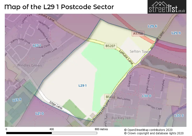
The L29 1 Postcode shares a border with L29 6 (LIVERPOOL), L29 9 (LIVERPOOL, Sefton), L21 0 (LIVERPOOL, Ford), L23 1 (LIVERPOOL, Thornton, Crosby) and L30 0 (BOOTLE).
The sector is within the post town of LIVERPOOL.
L29 1 is a postcode sector within the L2 postcode district which is within the L Liverpool postcode area.
The Royal Mail delivery office for the L29 1 postal sector is the Liverpool 1-3.
The area of the L29 1 postcode sector is 0.19 square miles which is 0.48 square kilometres or 118.91 square acres.

Map of the L29 1 Postcode Sector
Explore the L29 1 postcode sector by using our free interactive map.
| L | 2 | 9 | - | 1 | X | X |
| L | 2 | 9 | Space | 1 | Letter | Letter |
Official List of Streets
LIVERPOOL (1 Streets)
Unofficial Streets or Alternative Spellings
LIVERPOOL
BRICKWALL LANE SUNDIAL CLOSEBOOTLE
NORTHERN PERIMETER ROAD RED LOMES ALMONDS TURN BROOMS CROSS ROADBOOTLE,
BUCKLEY HILL LANECrosby
EDGE LANEThornton
LYDIATE LANEWeather Forecast for L29 1
Press Button to Show Forecast for Thornton (Merseyside)
| Time Period | Icon | Description | Temperature | Rain Probability | Wind |
|---|---|---|---|---|---|
| 15:00 to 18:00 | Light rain | 12.0°C (feels like 11.0°C) | 46.00% | W 9 mph | |
| 18:00 to 21:00 | Light rain | 12.0°C (feels like 10.0°C) | 49.00% | W 9 mph | |
| 21:00 to 00:00 | Light rain | 12.0°C (feels like 10.0°C) | 49.00% | SW 7 mph |
Press Button to Show Forecast for Thornton (Merseyside)
| Time Period | Icon | Description | Temperature | Rain Probability | Wind |
|---|---|---|---|---|---|
| 00:00 to 03:00 | Light rain | 11.0°C (feels like 10.0°C) | 48.00% | SW 7 mph | |
| 03:00 to 06:00 | Light rain | 11.0°C (feels like 9.0°C) | 44.00% | SSW 7 mph | |
| 06:00 to 09:00 | Cloudy | 11.0°C (feels like 10.0°C) | 12.00% | SSW 7 mph | |
| 09:00 to 12:00 | Overcast | 12.0°C (feels like 11.0°C) | 11.00% | SSW 9 mph | |
| 12:00 to 15:00 | Cloudy | 14.0°C (feels like 12.0°C) | 9.00% | SW 9 mph | |
| 15:00 to 18:00 | Cloudy | 14.0°C (feels like 13.0°C) | 10.00% | NW 7 mph | |
| 18:00 to 21:00 | Cloudy | 13.0°C (feels like 13.0°C) | 10.00% | NNW 7 mph | |
| 21:00 to 00:00 | Cloudy | 12.0°C (feels like 11.0°C) | 7.00% | NE 7 mph |
Press Button to Show Forecast for Thornton (Merseyside)
| Time Period | Icon | Description | Temperature | Rain Probability | Wind |
|---|---|---|---|---|---|
| 00:00 to 03:00 | Cloudy | 11.0°C (feels like 10.0°C) | 8.00% | E 7 mph | |
| 03:00 to 06:00 | Cloudy | 10.0°C (feels like 9.0°C) | 9.00% | ESE 7 mph | |
| 06:00 to 09:00 | Cloudy | 11.0°C (feels like 10.0°C) | 9.00% | E 7 mph | |
| 09:00 to 12:00 | Cloudy | 13.0°C (feels like 12.0°C) | 9.00% | ESE 7 mph | |
| 12:00 to 15:00 | Cloudy | 14.0°C (feels like 13.0°C) | 11.00% | SE 7 mph | |
| 15:00 to 18:00 | Light rain shower (day) | 14.0°C (feels like 13.0°C) | 35.00% | SE 7 mph | |
| 18:00 to 21:00 | Partly cloudy (day) | 13.0°C (feels like 12.0°C) | 12.00% | N 7 mph | |
| 21:00 to 00:00 | Partly cloudy (night) | 12.0°C (feels like 11.0°C) | 9.00% | N 7 mph |
House Prices in the L29 1 Postcode Sector
| Type of Property | 2018 Average | 2018 Sales | 2017 Average | 2017 Sales | 2016 Average | 2016 Sales | 2015 Average | 2015 Sales |
|---|---|---|---|---|---|---|---|---|
| Detached | £210,000 | 1 | £0 | 0 | £0 | 0 | £0 | 0 |
| Semi-Detached | £0 | 0 | £0 | 0 | £0 | 0 | £0 | 0 |
| Terraced | £0 | 0 | £0 | 0 | £0 | 0 | £0 | 0 |
| Flats | £0 | 0 | £0 | 0 | £0 | 0 | £0 | 0 |
Important Postcodes L29 1 in the Postcode Sector
L29 1YB is the postcode for Bootle and Netherton Fire Station, Buckley Hill Lane, and Sports Pavilion, Buckley Hill Road
| The L29 1 Sector is within these Local Authorities |
|
|---|---|
| The L29 1 Sector is within these Counties |
|
| The L29 1 Sector is within these Water Company Areas |
|