The L20 5 postcode sector is within the county of Merseyside.
Did you know? According to the 2021 Census, the L20 5 postcode sector is home to a bustling 2,903 residents!
Given that each sector allows for 400 unique postcode combinations. Letters C, I, K, M, O and V are not allowed in the last two letters of a postcode. With 71 postcodes already in use, this leaves 329 units available.
The L20 5 postal code covers the settlement of BOOTLE.
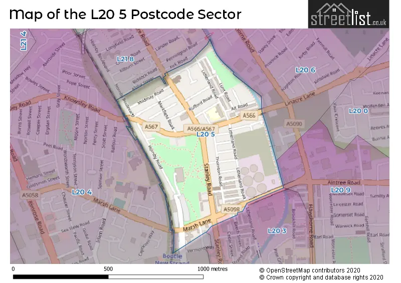
The L20 5 Postcode shares a border with L20 3 (BOOTLE, LIVERPOOL), L20 4 (BOOTLE), L20 6 (BOOTLE), L20 9 (BOOTLE) and L21 8 (LIVERPOOL, Litherland).
The sector is within the post town of BOOTLE.
L20 5 is a postcode sector within the L20 postcode district which is within the L Liverpool postcode area.
The Royal Mail delivery office for the L20 5 postal sector is the Bootle Delivery Office.
The area of the L20 5 postcode sector is 0.20 square miles which is 0.53 square kilometres or 129.90 square acres.
Waterways within the L20 5 postcode sector include the Leeds and Liverpool Canal.


Map of the L20 5 Postcode Sector
Explore the L20 5 postcode sector by using our free interactive map.
| L | 2 | 0 | - | 5 | X | X |
| L | 2 | 0 | Space | 5 | Letter | Letter |
Official List of Streets
BOOTLE (32 Streets)
Unofficial Streets or Alternative Spellings
BOOTLE
BEECH STREET DELAWARE ROAD OAK STREETKirkdale
STANLEY ROAD BECK ROAD BRABY ROAD HALSALL ROAD SAINT ANDREWS ROAD SUMMER WAYLIVERPOOL
LINACRE ROADBOOTLE,
HORNBY BOULEVARDWeather Forecast for L20 5
Press Button to Show Forecast for Litherland
| Time Period | Icon | Description | Temperature | Rain Probability | Wind |
|---|---|---|---|---|---|
| 21:00 to 00:00 | Cloudy | 8.0°C (feels like 6.0°C) | 4.00% | ENE 9 mph |
Press Button to Show Forecast for Litherland
| Time Period | Icon | Description | Temperature | Rain Probability | Wind |
|---|---|---|---|---|---|
| 00:00 to 03:00 | Cloudy | 7.0°C (feels like 4.0°C) | 5.00% | NNE 9 mph | |
| 03:00 to 06:00 | Cloudy | 6.0°C (feels like 3.0°C) | 7.00% | N 9 mph | |
| 06:00 to 09:00 | Light rain | 6.0°C (feels like 3.0°C) | 55.00% | N 9 mph | |
| 09:00 to 12:00 | Light rain | 7.0°C (feels like 4.0°C) | 57.00% | NNW 11 mph | |
| 12:00 to 15:00 | Light rain shower (day) | 8.0°C (feels like 4.0°C) | 43.00% | NW 13 mph | |
| 15:00 to 18:00 | Cloudy | 9.0°C (feels like 6.0°C) | 18.00% | WNW 16 mph | |
| 18:00 to 21:00 | Sunny day | 10.0°C (feels like 7.0°C) | 3.00% | W 13 mph | |
| 21:00 to 00:00 | Partly cloudy (night) | 9.0°C (feels like 6.0°C) | 1.00% | SW 11 mph |
Press Button to Show Forecast for Litherland
| Time Period | Icon | Description | Temperature | Rain Probability | Wind |
|---|---|---|---|---|---|
| 00:00 to 03:00 | Partly cloudy (night) | 8.0°C (feels like 5.0°C) | 3.00% | S 11 mph | |
| 03:00 to 06:00 | Cloudy | 7.0°C (feels like 4.0°C) | 19.00% | S 11 mph | |
| 06:00 to 09:00 | Partly cloudy (day) | 7.0°C (feels like 4.0°C) | 3.00% | SSE 11 mph | |
| 09:00 to 12:00 | Partly cloudy (day) | 11.0°C (feels like 8.0°C) | 7.00% | SSE 16 mph | |
| 12:00 to 15:00 | Cloudy | 13.0°C (feels like 10.0°C) | 14.00% | S 16 mph | |
| 15:00 to 18:00 | Light rain shower (day) | 13.0°C (feels like 10.0°C) | 33.00% | S 18 mph | |
| 18:00 to 21:00 | Cloudy | 13.0°C (feels like 9.0°C) | 13.00% | SSE 18 mph | |
| 21:00 to 00:00 | Cloudy | 11.0°C (feels like 8.0°C) | 5.00% | SSE 16 mph |
Press Button to Show Forecast for Litherland
| Time Period | Icon | Description | Temperature | Rain Probability | Wind |
|---|---|---|---|---|---|
| 00:00 to 03:00 | Cloudy | 10.0°C (feels like 7.0°C) | 6.00% | SSE 16 mph | |
| 03:00 to 06:00 | Partly cloudy (night) | 9.0°C (feels like 6.0°C) | 2.00% | SE 16 mph | |
| 06:00 to 09:00 | Cloudy | 9.0°C (feels like 6.0°C) | 5.00% | SE 16 mph | |
| 09:00 to 12:00 | Partly cloudy (day) | 12.0°C (feels like 9.0°C) | 1.00% | SE 16 mph | |
| 12:00 to 15:00 | Cloudy | 15.0°C (feels like 12.0°C) | 5.00% | SE 18 mph | |
| 15:00 to 18:00 | Cloudy | 16.0°C (feels like 13.0°C) | 8.00% | SE 16 mph | |
| 18:00 to 21:00 | Cloudy | 15.0°C (feels like 13.0°C) | 9.00% | SE 11 mph | |
| 21:00 to 00:00 | Partly cloudy (night) | 13.0°C (feels like 11.0°C) | 4.00% | ESE 9 mph |
Press Button to Show Forecast for Litherland
| Time Period | Icon | Description | Temperature | Rain Probability | Wind |
|---|---|---|---|---|---|
| 00:00 to 03:00 | Partly cloudy (night) | 12.0°C (feels like 10.0°C) | 5.00% | ESE 9 mph | |
| 03:00 to 06:00 | Cloudy | 11.0°C (feels like 9.0°C) | 9.00% | ESE 7 mph | |
| 06:00 to 09:00 | Cloudy | 11.0°C (feels like 10.0°C) | 12.00% | E 7 mph | |
| 09:00 to 12:00 | Cloudy | 13.0°C (feels like 11.0°C) | 13.00% | E 7 mph | |
| 12:00 to 15:00 | Cloudy | 14.0°C (feels like 13.0°C) | 17.00% | E 7 mph | |
| 15:00 to 18:00 | Light rain shower (day) | 15.0°C (feels like 14.0°C) | 35.00% | NE 7 mph | |
| 18:00 to 21:00 | Cloudy | 15.0°C (feels like 13.0°C) | 12.00% | NNE 9 mph | |
| 21:00 to 00:00 | Cloudy | 13.0°C (feels like 12.0°C) | 10.00% | NE 9 mph |
Schools and Places of Education Within the L20 5 Postcode Sector
Linacre Primary School
Community school
Thornton Road, Bootle, Merseyside, L20 5ED
Head: Miss Elizabeth Gunnion
Ofsted Rating: Requires improvement
Inspection: 2023-05-17 (346 days ago)
Website: Visit Linacre Primary School Website
Phone: 01519221466
Number of Pupils: 148
House Prices in the L20 5 Postcode Sector
| Type of Property | 2018 Average | 2018 Sales | 2017 Average | 2017 Sales | 2016 Average | 2016 Sales | 2015 Average | 2015 Sales |
|---|---|---|---|---|---|---|---|---|
| Detached | £0 | 0 | £0 | 0 | £74,950 | 1 | £165,000 | 1 |
| Semi-Detached | £0 | 0 | £0 | 0 | £116,000 | 1 | £123,317 | 3 |
| Terraced | £73,102 | 38 | £63,244 | 24 | £63,040 | 25 | £56,686 | 35 |
| Flats | £36,000 | 1 | £0 | 0 | £0 | 0 | £25,000 | 1 |
Important Postcodes L20 5 in the Postcode Sector
L20 5AQ is the postcode for Marie Clarke Family Centre, Linacre Lane
L20 5DQ is the postcode for North Park Health Centre, 290 Knowsley Road
L20 5ED is the postcode for Linacre Primary School, Thornton Road
L20 5HJ is the postcode for Merseyside Police, Marsh Lane Police Station, Marsh Lane
L20 5JJ is the postcode for Sefton Metropolitan Borough Council, Bootle Leisure Centre, Washington Parade, and BOOTLE LEISURE CENTRE, WASHINGTON PARADE
| The L20 5 Sector is within these Local Authorities |
|
|---|---|
| The L20 5 Sector is within these Counties |
|
| The L20 5 Sector is within these Water Company Areas |
|