The L24 9 postcode sector is within the county of Merseyside.
Did you know? According to the 2021 Census, the L24 9 postcode sector is home to a bustling 1,242 residents!
Given that each sector allows for 400 unique postcode combinations. Letters C, I, K, M, O and V are not allowed in the last two letters of a postcode. With 56 postcodes already in use, this leaves 344 units available.
The largest settlement in the L24 9 postal code is LIVERPOOL followed by Speke, and Halewood.
The L24 9 Postcode shares a border with L24 3 (LIVERPOOL, Speke), L26 3 (LIVERPOOL, Halewood), WA8 8 (WIDNES), L24 0 (LIVERPOOL, Speke), L24 2 (LIVERPOOL, Speke), L24 6 (LIVERPOOL), L19 5 (LIVERPOOL, Allerton, Garston), L19 2 (LIVERPOOL, Garston), L24 1 (LIVERPOOL, Liverpool Airport, Speke), L24 8 (Speke), L25 0 (LIVERPOOL, Hunts Cross, Woolton), L25 7 (Woolton, LIVERPOOL), L26 9 (LIVERPOOL, Halewood) and L26 1 (LIVERPOOL, Halewood).
The sector is within the post town of LIVERPOOL.
L24 9 is a postcode sector within the L24 postcode district which is within the L Liverpool postcode area.
The Royal Mail delivery office for the L24 9 postal sector is the Speke Delivery Office.
The area of the L24 9 postcode sector is 1.39 square miles which is 3.59 square kilometres or 887.95 square acres.

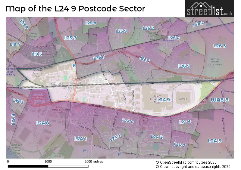
Map of the L24 9 Postcode Sector
Explore the L24 9 postcode sector by using our free interactive map.
| L | 2 | 4 | - | 9 | X | X |
| L | 2 | 4 | Space | 9 | Letter | Letter |
Official List of Streets
Speke (8 Streets)
LIVERPOOL (21 Streets)
Unofficial Streets or Alternative Spellings
LIVERPOOL,
HIGHER ROADSpeke
WESTERN AVENUELIVERPOOL
KINGSTHORNE PARK SPEKE HALL AVENUEHunts Cross
WOODEND AVENUEGarston
SPEKE ROADWeather Forecast for L24 9
Press Button to Show Forecast for Hunt's Cross
| Time Period | Icon | Description | Temperature | Rain Probability | Wind |
|---|---|---|---|---|---|
| 09:00 to 12:00 | Cloudy | 7.0°C (feels like 6.0°C) | 5.00% | E 4 mph | |
| 12:00 to 15:00 | Overcast | 9.0°C (feels like 8.0°C) | 9.00% | ENE 4 mph | |
| 15:00 to 18:00 | Cloudy | 10.0°C (feels like 9.0°C) | 7.00% | NE 4 mph | |
| 18:00 to 21:00 | Cloudy | 9.0°C (feels like 9.0°C) | 6.00% | NNE 4 mph | |
| 21:00 to 00:00 | Cloudy | 7.0°C (feels like 4.0°C) | 9.00% | NE 7 mph |
Press Button to Show Forecast for Hunt's Cross
| Time Period | Icon | Description | Temperature | Rain Probability | Wind |
|---|---|---|---|---|---|
| 00:00 to 03:00 | Partly cloudy (night) | 5.0°C (feels like 3.0°C) | 6.00% | E 7 mph | |
| 03:00 to 06:00 | Partly cloudy (night) | 3.0°C (feels like 1.0°C) | 7.00% | ESE 7 mph | |
| 06:00 to 09:00 | Cloudy | 4.0°C (feels like 2.0°C) | 8.00% | E 7 mph | |
| 09:00 to 12:00 | Partly cloudy (day) | 8.0°C (feels like 6.0°C) | 5.00% | E 7 mph | |
| 12:00 to 15:00 | Overcast | 10.0°C (feels like 8.0°C) | 14.00% | E 9 mph | |
| 15:00 to 18:00 | Light rain | 11.0°C (feels like 9.0°C) | 46.00% | ENE 9 mph | |
| 18:00 to 21:00 | Cloudy | 10.0°C (feels like 8.0°C) | 15.00% | NE 9 mph | |
| 21:00 to 00:00 | Cloudy | 8.0°C (feels like 5.0°C) | 15.00% | ENE 9 mph |
Press Button to Show Forecast for Hunt's Cross
| Time Period | Icon | Description | Temperature | Rain Probability | Wind |
|---|---|---|---|---|---|
| 00:00 to 03:00 | Cloudy | 6.0°C (feels like 3.0°C) | 17.00% | NE 9 mph | |
| 03:00 to 06:00 | Cloudy | 6.0°C (feels like 3.0°C) | 19.00% | NNE 9 mph | |
| 06:00 to 09:00 | Heavy rain | 6.0°C (feels like 3.0°C) | 71.00% | NNE 11 mph | |
| 09:00 to 12:00 | Light rain | 8.0°C (feels like 5.0°C) | 51.00% | N 11 mph | |
| 12:00 to 15:00 | Heavy rain | 9.0°C (feels like 6.0°C) | 75.00% | N 11 mph | |
| 15:00 to 18:00 | Heavy rain | 10.0°C (feels like 7.0°C) | 74.00% | N 11 mph | |
| 18:00 to 21:00 | Cloudy | 10.0°C (feels like 8.0°C) | 17.00% | NW 11 mph | |
| 21:00 to 00:00 | Clear night | 8.0°C (feels like 6.0°C) | 11.00% | W 9 mph |
House Prices in the L24 9 Postcode Sector
| Type of Property | 2018 Average | 2018 Sales | 2017 Average | 2017 Sales | 2016 Average | 2016 Sales | 2015 Average | 2015 Sales |
|---|---|---|---|---|---|---|---|---|
| Detached | £164,000 | 3 | £165,000 | 1 | £169,950 | 1 | £0 | 0 |
| Semi-Detached | £130,778 | 9 | £118,062 | 8 | £112,588 | 8 | £127,639 | 44 |
| Terraced | £114,993 | 7 | £120,393 | 7 | £139,488 | 4 | £102,500 | 3 |
| Flats | £91,400 | 5 | £70,250 | 4 | £78,750 | 4 | £69,357 | 7 |
Important Postcodes L24 9 in the Postcode Sector
L24 9NH is the postcode for Brigade Workshops, Merseyside Fire and Rescue Service
| The L24 9 Sector is within these Local Authorities |
|
|---|---|
| The L24 9 Sector is within these Counties |
|
| The L24 9 Sector is within these Water Company Areas |
|