The L29 postcode district is a postal district located in the L Liverpool postcode area with a population of 500 residents according to the 2021 England and Wales Census.
The area of the L29 postcode district is 3.00 square miles which is 7.76 square kilometres or 1,918.44 acres.
Currently, the L29 district has about 22 postcode units spread across 6 geographic postcode sectors.
Given that each sector allows for 400 unique postcode combinations, the district has a capacity of 2,400 postcodes. With 22 postcodes already in use, this leaves 2378 units available.
The largest settlement in the L29 postal code is LIVERPOOL followed by Thornton, and Sefton.
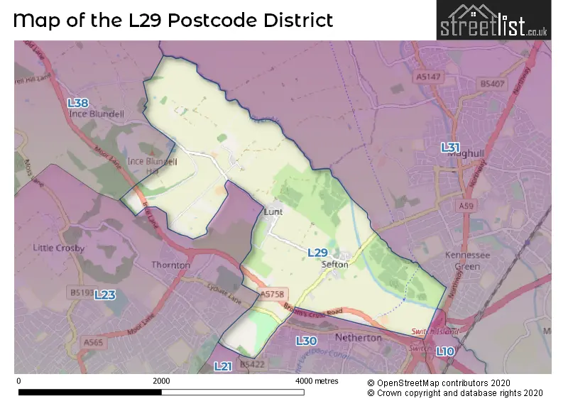
The L29 Postcode shares a border with L23 (LIVERPOOL, Crosby, Thornton), L10 (LIVERPOOL, Fazakerley, Aintree), L30 (BOOTLE, Netherton) and L31 (LIVERPOOL, Maghull, Melling).
The primary settlement in the L29 postcode district is Liverpool, located in the county of Merseyside in England. It is the most significant settlement in this postcode district. Other significant settlements include Thornton and Sefton, both also located in Liverpool. The most significant post town in this postcode district is Liverpool.
For the district L29, we have data on 7 postcode sectors. Here's a breakdown: The sector L29 1, covers Liverpool in Merseyside. The sector L29 3 is non-geographic. It's often designated for PO Boxes, large organisations, or special services. The sector L29 5, covers Liverpool and Thornton in Merseyside. The sector L29 6, covers Liverpool in Merseyside. The sector L29 7, covers Liverpool and Thornton in Merseyside. The sector L29 8, covers Liverpool and Thornton in Merseyside. The sector L29 9, covers Liverpool and Sefton in Merseyside.

Map of the L29 Postcode District
Explore the L29 postcode district by using our free interactive map.
When it comes to local government, postal geography often disregards political borders. However, for a breakdown in the L29 District: the district mostly encompasses the Sefton District (B) area with a total of 22 postcodes.
Recent House Sales in L29
| Date | Price | Address |
|---|---|---|
| 13/02/2023 | £350,000 | Brickwall Lane, Liverpool, L29 9AD |
| 20/01/2023 | £410,000 | Brickwall Green, Liverpool, L29 9AF |
| 16/12/2022 | £250,000 | Lunt Road, Liverpool, L29 7WB |
| 28/10/2022 | £262,500 | Mill Stream Close, Liverpool, L29 7WJ |
| 13/10/2022 | £335,000 | Sefton Mill Court, Liverpool, L29 7WG |
| 30/09/2022 | £305,000 | Mill Stream Close, Liverpool, L29 7WJ |
| 30/09/2022 | £225,000 | Wingfield Close, Liverpool, L29 7WE |
| 27/07/2022 | £238,000 | Mill Weir Gardens, Liverpool, L29 7WH |
| 08/07/2022 | £880,000 | Glebe End, Liverpool, L29 6YB |
| 25/05/2022 | £70,000 | Lunt Lane, Liverpool, L29 7WL |
Where is the L29 Postcode District?
The postcode district L29 is located in Liverpool. It is nearby towns such as Bootle to the south, Ormskirk to the northeast, Wallasey to the southwest, Southport to the north, Skelmersdale to the east, and Prescot to the southeast. Additionally, L29 is approximately 183.45 miles away from the center of London.
The district is within the post town of LIVERPOOL.
The sector has postcodes within the nation of England.
The L29 Postcode District is in the Sefton region of Merseyside within the North West (England).
Weather Forecast for L29
Press Button to Show Forecast for Thornton (Merseyside)
| Time Period | Icon | Description | Temperature | Rain Probability | Wind |
|---|---|---|---|---|---|
| 00:00 to 03:00 | Cloudy | 12.0°C (feels like 12.0°C) | 3.00% | N 2 mph | |
| 03:00 to 06:00 | Cloudy | 12.0°C (feels like 12.0°C) | 3.00% | ESE 2 mph | |
| 06:00 to 09:00 | Cloudy | 13.0°C (feels like 13.0°C) | 4.00% | SE 2 mph | |
| 09:00 to 12:00 | Cloudy | 17.0°C (feels like 16.0°C) | 4.00% | SE 7 mph | |
| 12:00 to 15:00 | Cloudy | 20.0°C (feels like 19.0°C) | 4.00% | SSE 4 mph | |
| 15:00 to 18:00 | Cloudy | 21.0°C (feels like 20.0°C) | 4.00% | SSE 4 mph | |
| 18:00 to 21:00 | Cloudy | 20.0°C (feels like 19.0°C) | 4.00% | WSW 4 mph | |
| 21:00 to 00:00 | Partly cloudy (night) | 16.0°C (feels like 15.0°C) | 1.00% | WSW 4 mph |
Press Button to Show Forecast for Thornton (Merseyside)
| Time Period | Icon | Description | Temperature | Rain Probability | Wind |
|---|---|---|---|---|---|
| 00:00 to 03:00 | Clear night | 14.0°C (feels like 14.0°C) | 1.00% | SW 2 mph | |
| 03:00 to 06:00 | Partly cloudy (night) | 13.0°C (feels like 13.0°C) | 0.00% | SE 2 mph | |
| 06:00 to 09:00 | Partly cloudy (day) | 14.0°C (feels like 14.0°C) | 1.00% | SE 4 mph | |
| 09:00 to 12:00 | Sunny day | 17.0°C (feels like 16.0°C) | 0.00% | SE 7 mph | |
| 12:00 to 15:00 | Partly cloudy (day) | 20.0°C (feels like 18.0°C) | 2.00% | SSE 9 mph | |
| 15:00 to 18:00 | Partly cloudy (day) | 20.0°C (feels like 18.0°C) | 1.00% | S 9 mph | |
| 18:00 to 21:00 | Partly cloudy (day) | 20.0°C (feels like 18.0°C) | 1.00% | S 7 mph | |
| 21:00 to 00:00 | Partly cloudy (night) | 17.0°C (feels like 17.0°C) | 1.00% | S 4 mph |
Press Button to Show Forecast for Thornton (Merseyside)
| Time Period | Icon | Description | Temperature | Rain Probability | Wind |
|---|---|---|---|---|---|
| 00:00 to 03:00 | Partly cloudy (night) | 16.0°C (feels like 15.0°C) | 1.00% | SE 7 mph | |
| 03:00 to 06:00 | Cloudy | 15.0°C (feels like 13.0°C) | 3.00% | SE 9 mph | |
| 06:00 to 09:00 | Cloudy | 15.0°C (feels like 13.0°C) | 3.00% | SE 9 mph | |
| 09:00 to 12:00 | Cloudy | 17.0°C (feels like 15.0°C) | 4.00% | SE 9 mph | |
| 12:00 to 15:00 | Cloudy | 19.0°C (feels like 17.0°C) | 6.00% | SSE 9 mph | |
| 15:00 to 18:00 | Light rain shower (day) | 19.0°C (feels like 17.0°C) | 36.00% | S 9 mph | |
| 18:00 to 21:00 | Heavy rain shower (day) | 17.0°C (feels like 16.0°C) | 53.00% | SSW 9 mph | |
| 21:00 to 00:00 | Overcast | 16.0°C (feels like 15.0°C) | 21.00% | SSW 7 mph |
Press Button to Show Forecast for Thornton (Merseyside)
| Time Period | Icon | Description | Temperature | Rain Probability | Wind |
|---|---|---|---|---|---|
| 00:00 to 03:00 | Cloudy | 15.0°C (feels like 14.0°C) | 20.00% | S 7 mph | |
| 03:00 to 06:00 | Cloudy | 14.0°C (feels like 13.0°C) | 16.00% | SSW 7 mph | |
| 06:00 to 09:00 | Cloudy | 13.0°C (feels like 12.0°C) | 18.00% | SSE 7 mph | |
| 09:00 to 12:00 | Cloudy | 14.0°C (feels like 13.0°C) | 19.00% | SSW 9 mph | |
| 12:00 to 15:00 | Cloudy | 15.0°C (feels like 14.0°C) | 21.00% | SSW 9 mph | |
| 15:00 to 18:00 | Light rain shower (day) | 16.0°C (feels like 14.0°C) | 41.00% | S 11 mph | |
| 18:00 to 21:00 | Heavy rain | 15.0°C (feels like 13.0°C) | 76.00% | S 11 mph | |
| 21:00 to 00:00 | Light rain | 14.0°C (feels like 12.0°C) | 54.00% | SSW 11 mph |
| Postcode Sector | Delivery Office |
|---|---|
| L29 1 | Crosby Delivery Office |
| L29 3 | Crosby Delivery Office |
| L29 5 | Crosby Delivery Office |
| L29 6 | Crosby Delivery Office |
| L29 7 | Crosby Delivery Office |
| L29 8 | Crosby Delivery Office |
| L29 9 | Crosby Delivery Office |
| L | 2 | 9 | - | X | X | X |
| L | 2 | 9 | Space | Numeric | Letter | Letter |
Current Monthly Rental Prices
| # Bedrooms | Min Price | Max Price | Avg Price |
|---|
Current House Prices
| # Bedrooms | Min Price | Max Price | Avg Price |
|---|---|---|---|
| 3 | £300,000 | £410,000 | £355,000 |
| 4 | £650,000 | £650,000 | £650,000 |
Estate Agents who Operate in the L29 District
| Logo | Name | Brand Name | Address | Contact Number | Total Properties |
|---|---|---|---|---|---|
 | Maghull | Alastair Saville | 25 Central Square, Maghull, Liverpool, L31 0AE | 0151 453 5689 | 3 |
Yearly House Price Averages for the L29 Postcode District
| Type of Property | 2018 Average | 2018 Sales | 2017 Average | 2017 Sales | 2016 Average | 2016 Sales | 2015 Average | 2015 Sales |
|---|---|---|---|---|---|---|---|---|
| Detached | £318,571 | 7 | £367,992 | 6 | £201,500 | 2 | £277,667 | 3 |
| Semi-Detached | £258,333 | 3 | £238,500 | 3 | £223,792 | 12 | £252,500 | 2 |
| Terraced | £276,750 | 4 | £213,000 | 1 | £275,000 | 4 | £193,875 | 4 |
| Flats | £0 | 0 | £0 | 0 | £0 | 0 | £0 | 0 |