The L23 postcode district is a postal district located in the L Liverpool postcode area with a population of 30,463 residents according to the 2021 England and Wales Census.
The area of the L23 postcode district is 5.19 square miles which is 13.44 square kilometres or 3,320.50 acres.
Currently, the L23 district has about 680 postcode units spread across 10 geographic postcode sectors.
Given that each sector allows for 400 unique postcode combinations, the district has a capacity of 4,000 postcodes. With 680 postcodes already in use, this leaves 3320 units available.
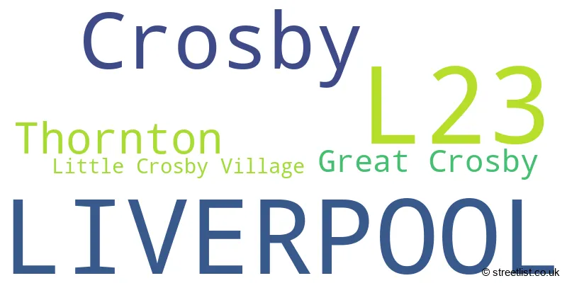
The largest settlement in the L23 postal code is LIVERPOOL followed by Crosby, and Thornton.
The postcode area has a boundary with The Irish Sea.
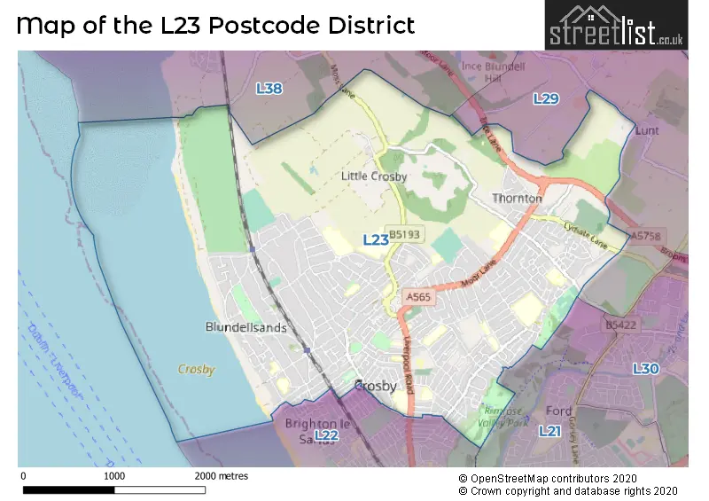
The L23 Postcode shares a border with L21 (LIVERPOOL, Litherland, Seaforth), L22 (Waterloo, LIVERPOOL, Brighton-le-Sands), L38 (Hightown, LIVERPOOL, Ince Blundell) and L29 (LIVERPOOL, Thornton, Sefton).
The primary settlement in the L23 postcode district is Liverpool, located in the county of Merseyside in England. Other significant settlements in this district include Crosby, Great Crosby, and Thornton.
For the district L23, we have data on 10 postcode sectors. Here's a breakdown: The sector L23 0, covers Liverpool and Crosby in Merseyside. The sector L23 1, covers Liverpool and Thornton in Merseyside. The sector L23 2, covers Liverpool and Crosby in Merseyside. The sector L23 3, covers Liverpool and Crosby in Merseyside. The sector L23 4, covers Thornton and Liverpool in Merseyside. The sector L23 5, covers Crosby and Liverpool in Merseyside. The sector L23 6, covers Liverpool and Crosby in Merseyside. The sector L23 7, covers Crosby and Liverpool in Merseyside. The sector L23 8, covers Liverpool and Crosby in Merseyside. The sector L23 9, covers Liverpool and Crosby in Merseyside.

Map of the L23 Postcode District
Explore the L23 postcode district by using our free interactive map.
When it comes to local government, postal geography often disregards political borders. However, for a breakdown in the L23 District: the district mostly encompasses the Sefton District (B) area with a total of 681 postcodes.
Recent House Sales in L23
| Date | Price | Address |
|---|---|---|
| 13/10/2023 | £78,000 | Nicholas Road, Liverpool, L23 6TS |
| 12/10/2023 | £440,000 | Hillcrest Road, Crosby, Liverpool, L23 9XS |
| 03/10/2023 | £225,000 | Dowhills Road, Liverpool, L23 8SW |
| 29/09/2023 | £130,000 | Nicholas Road, Liverpool, L23 6XN |
| 29/09/2023 | £225,000 | Blundellsands Road West, Liverpool, L23 6BA |
| 27/09/2023 | £110,000 | College Green Flats, Liverpool, L23 3DR |
| 25/09/2023 | £240,000 | Halifax Crescent, Liverpool, L23 1TH |
| 18/09/2023 | £177,624 | St Lukes Road, Liverpool, L23 5SY |
| 15/09/2023 | £228,000 | Sunnyside Road, Liverpool, L23 3AZ |
| 05/09/2023 | £275,000 | Lakeside Gardens, Crosby, Liverpool, L23 1TE |
Weather Forecast for L23
Press Button to Show Forecast for Great Crosby
| Time Period | Icon | Description | Temperature | Rain Probability | Wind |
|---|---|---|---|---|---|
| 03:00 to 06:00 | Partly cloudy (night) | 6.0°C (feels like 3.0°C) | 2.00% | ENE 7 mph | |
| 06:00 to 09:00 | Partly cloudy (day) | 5.0°C (feels like 3.0°C) | 2.00% | ENE 7 mph | |
| 09:00 to 12:00 | Partly cloudy (day) | 8.0°C (feels like 6.0°C) | 2.00% | E 9 mph | |
| 12:00 to 15:00 | Overcast | 10.0°C (feels like 8.0°C) | 15.00% | ENE 7 mph | |
| 15:00 to 18:00 | Overcast | 10.0°C (feels like 8.0°C) | 17.00% | ENE 9 mph | |
| 18:00 to 21:00 | Overcast | 9.0°C (feels like 7.0°C) | 11.00% | NE 9 mph | |
| 21:00 to 00:00 | Cloudy | 8.0°C (feels like 6.0°C) | 6.00% | NE 9 mph |
Press Button to Show Forecast for Great Crosby
| Time Period | Icon | Description | Temperature | Rain Probability | Wind |
|---|---|---|---|---|---|
| 00:00 to 03:00 | Partly cloudy (night) | 7.0°C (feels like 4.0°C) | 2.00% | NE 7 mph | |
| 03:00 to 06:00 | Cloudy | 6.0°C (feels like 3.0°C) | 4.00% | NNE 9 mph | |
| 06:00 to 09:00 | Cloudy | 6.0°C (feels like 4.0°C) | 8.00% | N 9 mph | |
| 09:00 to 12:00 | Cloudy | 8.0°C (feels like 6.0°C) | 10.00% | NNW 11 mph | |
| 12:00 to 15:00 | Partly cloudy (day) | 9.0°C (feels like 6.0°C) | 8.00% | NW 13 mph | |
| 15:00 to 18:00 | Sunny day | 10.0°C (feels like 7.0°C) | 7.00% | WNW 13 mph | |
| 18:00 to 21:00 | Sunny day | 10.0°C (feels like 7.0°C) | 3.00% | W 11 mph | |
| 21:00 to 00:00 | Clear night | 9.0°C (feels like 7.0°C) | 2.00% | SW 11 mph |
Press Button to Show Forecast for Great Crosby
| Time Period | Icon | Description | Temperature | Rain Probability | Wind |
|---|---|---|---|---|---|
| 00:00 to 03:00 | Partly cloudy (night) | 8.0°C (feels like 6.0°C) | 2.00% | SSW 11 mph | |
| 03:00 to 06:00 | Cloudy | 7.0°C (feels like 5.0°C) | 6.00% | S 11 mph | |
| 06:00 to 09:00 | Cloudy | 7.0°C (feels like 4.0°C) | 9.00% | SSE 13 mph | |
| 09:00 to 12:00 | Partly cloudy (day) | 10.0°C (feels like 7.0°C) | 2.00% | SSE 13 mph | |
| 12:00 to 15:00 | Cloudy | 13.0°C (feels like 10.0°C) | 8.00% | S 16 mph | |
| 15:00 to 18:00 | Cloudy | 13.0°C (feels like 10.0°C) | 10.00% | S 16 mph | |
| 18:00 to 21:00 | Cloudy | 13.0°C (feels like 10.0°C) | 10.00% | SSE 16 mph | |
| 21:00 to 00:00 | Partly cloudy (night) | 11.0°C (feels like 9.0°C) | 3.00% | SSE 13 mph |
Press Button to Show Forecast for Great Crosby
| Time Period | Icon | Description | Temperature | Rain Probability | Wind |
|---|---|---|---|---|---|
| 00:00 to 03:00 | Partly cloudy (night) | 10.0°C (feels like 7.0°C) | 4.00% | SE 13 mph | |
| 03:00 to 06:00 | Cloudy | 9.0°C (feels like 6.0°C) | 7.00% | SE 13 mph | |
| 06:00 to 09:00 | Partly cloudy (day) | 9.0°C (feels like 6.0°C) | 3.00% | SE 13 mph | |
| 09:00 to 12:00 | Partly cloudy (day) | 12.0°C (feels like 9.0°C) | 4.00% | SE 13 mph | |
| 12:00 to 15:00 | Partly cloudy (day) | 15.0°C (feels like 11.0°C) | 5.00% | SE 16 mph | |
| 15:00 to 18:00 | Cloudy | 15.0°C (feels like 13.0°C) | 11.00% | SE 13 mph | |
| 18:00 to 21:00 | Partly cloudy (day) | 15.0°C (feels like 12.0°C) | 6.00% | SE 11 mph | |
| 21:00 to 00:00 | Cloudy | 13.0°C (feels like 11.0°C) | 7.00% | ESE 11 mph |
Where is the L23 Postcode District?
The postcode district for L23 is located in Liverpool. It is nearby the towns of Bootle, Wallasey, Ormskirk, Southport, and Skelmersdale. The distance from L23 to London is approximately 184.05 miles.
The district is within the post town of LIVERPOOL.
The sector has postcodes within the nation of England.
The L23 Postcode District is in the Sefton region of Merseyside within the North West (England).
Postcode Sectors within the L23 District
| Postcode Sector | Delivery Office |
|---|---|
| L23 0 | Crosby Delivery Office |
| L23 1 | Crosby Delivery Office |
| L23 2 | Crosby Delivery Office |
| L23 3 | Crosby Delivery Office |
| L23 4 | Crosby Delivery Office |
| L23 5 | Crosby Delivery Office |
| L23 6 | Crosby Delivery Office |
| L23 7 | Crosby Delivery Office |
| L23 8 | Crosby Delivery Office |
| L23 9 | Crosby Delivery Office |
| L | 2 | 3 | - | X | X | X |
| L | 2 | 3 | Space | Numeric | Letter | Letter |
Current Monthly Rental Prices
| # Bedrooms | Min Price | Max Price | Avg Price |
|---|---|---|---|
| £1,100 | £4,000 | £2,200 | |
| 1 | £650 | £650 | £650 |
| 2 | £800 | £1,300 | £1,038 |
| 3 | £850 | £1,100 | £969 |
| 4 | £1,900 | £1,900 | £1,900 |
| 6 | £3,750 | £3,750 | £3,750 |
Current House Prices
| # Bedrooms | Min Price | Max Price | Avg Price |
|---|---|---|---|
| £220,000 | £750,000 | £413,333 | |
| 1 | £69,500 | £195,000 | £119,405 |
| 2 | £110,000 | £400,000 | £206,705 |
| 3 | £150,000 | £775,000 | £291,233 |
| 4 | £230,000 | £990,000 | £491,665 |
| 5 | £450,000 | £925,000 | £692,222 |
| 6 | £475,000 | £1,700,000 | £816,000 |
| 7 | £325,000 | £895,000 | £632,990 |
Estate Agents who Operate in the L23 District
| Logo | Name | Brand Name | Address | Contact Number | Total Properties |
|---|---|---|---|---|---|
 | Crosby | Abode | 82 Coronation Road, Crosby, Liverpool, L23 5RH | 0151 453 8369 | 40 |
 | Great Crosby | Michael Moon | 54 Liverpool Road, Great Crosby, Liverpool, L23 5SG | 0151 453 9555 | 36 |
 | Crosby | Berkeley Shaw Estate Agents | 35 Liverpool Road, Crosby, Liverpool, L23 5SD | 0151 924 6000 | 28 |
 | Crosby | Entwistle Green | 86 Coronation Road, Crosby, Liverpool, L23 5RH | 0151 453 7877 | 27 |
 | Crosby | Clive Watkin | 76-78 Coronation Road, Crosby, Liverpool, L23 5RH | 0151 453 4173 | 22 |
| Type of Property | 2018 Average | 2018 Sales | 2017 Average | 2017 Sales | 2016 Average | 2016 Sales | 2015 Average | 2015 Sales |
|---|---|---|---|---|---|---|---|---|
| Detached | £412,702 | 91 | £425,281 | 68 | £385,577 | 86 | £359,374 | 88 |
| Semi-Detached | £234,181 | 265 | £230,487 | 244 | £212,246 | 237 | £205,843 | 260 |
| Terraced | £161,034 | 94 | £168,955 | 56 | £155,371 | 61 | £141,261 | 69 |
| Flats | £160,690 | 100 | £158,613 | 107 | £142,286 | 136 | £145,399 | 99 |