The L4 5 postcode sector is within the county of Merseyside.
Did you know? According to the 2021 Census, the L4 5 postcode sector is home to a bustling 5,738 residents!
Given that each sector allows for 400 unique postcode combinations. Letters C, I, K, M, O and V are not allowed in the last two letters of a postcode. With 114 postcodes already in use, this leaves 286 units available.
The largest settlements in the L4 5 postal code are LIVERPOOL and Walton.
The L4 5 Postcode shares a border with L4 0 (LIVERPOOL, Walton), L4 2 (LIVERPOOL, Anfield, Walton), L4 3 (LIVERPOOL, Walton), L4 4 (LIVERPOOL, Kirkdale), L4 6 (LIVERPOOL, Walton), L9 1 (LIVERPOOL, Walton) and L20 9 (BOOTLE).
The sector is within the post town of LIVERPOOL.
L4 5 is a postcode sector within the L4 postcode district which is within the L Liverpool postcode area.
The Royal Mail delivery office for the L4 5 postal sector is the Liverpool 4-5.
The area of the L4 5 postcode sector is 0.20 square miles which is 0.53 square kilometres or 129.94 square acres.

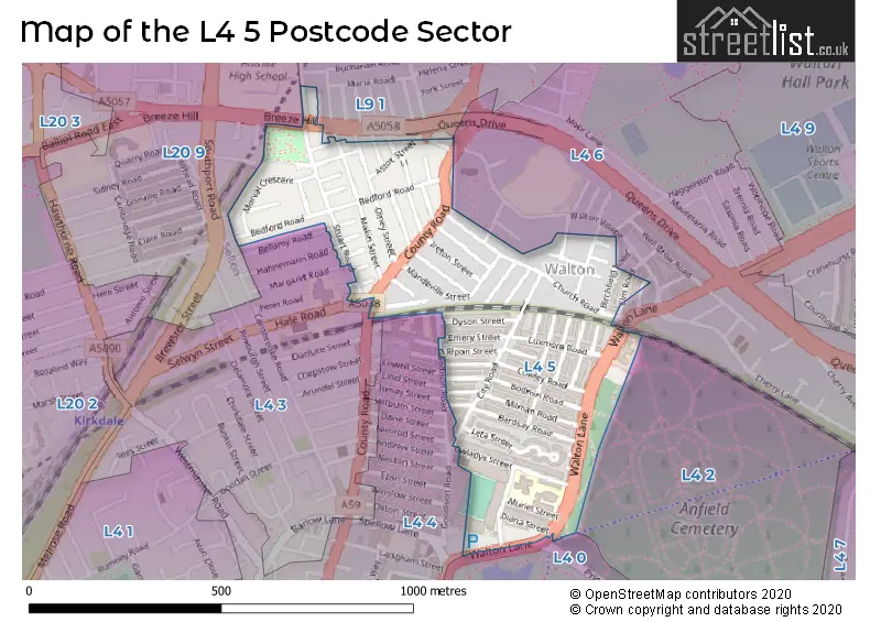
Map of the L4 5 Postcode Sector
Explore the L4 5 postcode sector by using our free interactive map.
| L | 4 | - | 5 | X | X |
| L | 4 | Space | 5 | Letter | Letter |
Official List of Streets
LIVERPOOL (67 Streets)
Unofficial Streets or Alternative Spellings
Weather Forecast for L4 5
Press Button to Show Forecast for Everton F.C.
| Time Period | Icon | Description | Temperature | Rain Probability | Wind |
|---|---|---|---|---|---|
| 09:00 to 12:00 | Partly cloudy (day) | 7.0°C (feels like 5.0°C) | 6.00% | E 4 mph | |
| 12:00 to 15:00 | Cloudy | 9.0°C (feels like 8.0°C) | 6.00% | NNE 4 mph | |
| 15:00 to 18:00 | Cloudy | 9.0°C (feels like 8.0°C) | 6.00% | N 7 mph | |
| 18:00 to 21:00 | Partly cloudy (day) | 9.0°C (feels like 7.0°C) | 4.00% | NNE 7 mph | |
| 21:00 to 00:00 | Cloudy | 7.0°C (feels like 4.0°C) | 7.00% | NE 9 mph |
Press Button to Show Forecast for Everton F.C.
| Time Period | Icon | Description | Temperature | Rain Probability | Wind |
|---|---|---|---|---|---|
| 00:00 to 03:00 | Partly cloudy (night) | 5.0°C (feels like 3.0°C) | 6.00% | ESE 9 mph | |
| 03:00 to 06:00 | Partly cloudy (night) | 4.0°C (feels like 2.0°C) | 6.00% | ESE 7 mph | |
| 06:00 to 09:00 | Partly cloudy (day) | 4.0°C (feels like 2.0°C) | 4.00% | E 7 mph | |
| 09:00 to 12:00 | Cloudy | 8.0°C (feels like 6.0°C) | 8.00% | ESE 7 mph | |
| 12:00 to 15:00 | Overcast | 10.0°C (feels like 8.0°C) | 12.00% | E 7 mph | |
| 15:00 to 18:00 | Overcast | 10.0°C (feels like 9.0°C) | 18.00% | NE 7 mph | |
| 18:00 to 21:00 | Cloudy | 10.0°C (feels like 8.0°C) | 14.00% | ENE 9 mph | |
| 21:00 to 00:00 | Cloudy | 8.0°C (feels like 6.0°C) | 13.00% | NE 9 mph |
Press Button to Show Forecast for Everton F.C.
| Time Period | Icon | Description | Temperature | Rain Probability | Wind |
|---|---|---|---|---|---|
| 00:00 to 03:00 | Light rain | 6.0°C (feels like 3.0°C) | 45.00% | NE 9 mph | |
| 03:00 to 06:00 | Cloudy | 6.0°C (feels like 3.0°C) | 15.00% | NNE 11 mph | |
| 06:00 to 09:00 | Light rain | 7.0°C (feels like 3.0°C) | 48.00% | NNE 11 mph | |
| 09:00 to 12:00 | Cloudy | 8.0°C (feels like 5.0°C) | 20.00% | NNE 11 mph | |
| 12:00 to 15:00 | Light rain | 9.0°C (feels like 6.0°C) | 52.00% | N 11 mph | |
| 15:00 to 18:00 | Heavy rain | 10.0°C (feels like 7.0°C) | 69.00% | N 11 mph | |
| 18:00 to 21:00 | Partly cloudy (day) | 10.0°C (feels like 7.0°C) | 14.00% | NNW 13 mph | |
| 21:00 to 00:00 | Partly cloudy (night) | 9.0°C (feels like 6.0°C) | 9.00% | WNW 11 mph |
Schools and Places of Education Within the L4 5 Postcode Sector
Gwladys Street Primary and Nursery School
Community school
Walton Lane, Liverpool, Merseyside, L4 5RW
Head: Ms Nicola Booth
Ofsted Rating: Good
Inspection: 2023-07-04 (297 days ago)
Website: Visit Gwladys Street Primary and Nursery School Website
Phone: 01515250843
Number of Pupils: 412
House Prices in the L4 5 Postcode Sector
| Type of Property | 2018 Average | 2018 Sales | 2017 Average | 2017 Sales | 2016 Average | 2016 Sales | 2015 Average | 2015 Sales |
|---|---|---|---|---|---|---|---|---|
| Detached | £0 | 0 | £0 | 0 | £0 | 0 | £40,000 | 1 |
| Semi-Detached | £53,000 | 1 | £88,975 | 6 | £122,400 | 5 | £106,125 | 2 |
| Terraced | £53,937 | 99 | £54,765 | 95 | £51,714 | 92 | £52,468 | 85 |
| Flats | £60,500 | 2 | £58,000 | 4 | £70,000 | 1 | £55,000 | 9 |
Important Postcodes L4 5 in the Postcode Sector
L4 5RW is the postcode for JUNIORS BLOCK, Gwladys Street Cp & Nursery School, Gwladys Street, and INFANT'S BLOCK, Gwladys Street Cp & Nursery School, Gwladys Street
L4 5XF is the postcode for Merseyside Police, Walton Lane
| The L4 5 Sector is within these Local Authorities |
|
|---|---|
| The L4 5 Sector is within these Counties |
|
| The L4 5 Sector is within these Water Company Areas |
|