The L40 postcode district is a postal district located in the L Liverpool postcode area with a population of 19,363 residents according to the 2021 England and Wales Census.
The area of the L40 postcode district is 35.20 square miles which is 91.17 square kilometres or 22,529.16 acres.
Currently, the L40 district has about 543 postcode units spread across 10 geographic postcode sectors.
Given that each sector allows for 400 unique postcode combinations, the district has a capacity of 4,000 postcodes. With 543 postcodes already in use, this leaves 3457 units available.
The largest settlement in the L40 postal code is Burscough followed by Scarisbrick, and Mawdesley.
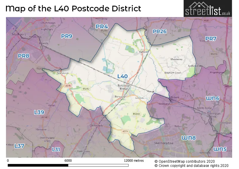
The L40 Postcode shares a border with PR8 (SOUTHPORT, Scarisbrick, Ainsdale), PR9 (SOUTHPORT, Banks), L39 (ORMSKIRK, Aughton, Halsall), WN8 (SKELMERSDALE, Upholland, Parbold), PR26 (LEYLAND, Croston, Farington Moss), WN6 (Standish, WIGAN, Shevington) and PR4 (Kirkham, Cottam, Freckleton).
The primary settlement in the L40 postcode district is Ormskirk, located in the county of Lancashire within England. Other significant settlements in the district include Burscough, Holmeswood, Rufford, Mawdesley, Bispham, Lathom, Westhead, and Scarisbrick. The post town for all these settlements is Ormskirk, which has the highest number of postcodes in the district.
For the district L40, we have data on 10 postcode sectors. Here's a breakdown: The sector L40 0, covers Burscough in Lancashire. The sector L40 1, covers Rufford and Holmeswood in Lancashire. The sector L40 2, covers Mawdesley in Lancashire. The sector L40 3, covers Mawdesley and Bispham in Lancashire. The sector L40 4, covers Burscough and Lathom in Lancashire. The sector L40 5, covers Burscough and Lathom in Lancashire. The sector L40 6, covers Westhead and Lathom in Lancashire. The sector L40 7, covers Burscough in Lancashire. The sector L40 8, covers Scarisbrick and Burscough and Burscough Industrial Estate in Lancashire. The sector L40 9, covers Scarisbrick in Lancashire.

Map of the L40 Postcode District
Explore the L40 postcode district by using our free interactive map.
When it comes to local government, postal geography often disregards political borders. However, for a breakdown in the L40 District: the district mostly encompasses the West Lancashire District (B) (507 postcodes), and finally, the Chorley District (B) area (54 postcodes).
Recent House Sales in L40
| Date | Price | Address |
|---|---|---|
| 20/10/2023 | £275,000 | St Andrews Close, Burscough, Ormskirk, L40 7BH |
| 26/09/2023 | £218,156 | Martin Lane, Burscough, Ormskirk, L40 0RT |
| 26/09/2023 | £145,000 | Bescar Brow Lane, Scarisbrick, Ormskirk, L40 9QG |
| 08/09/2023 | £285,000 | Mere Avenue, Burscough, Ormskirk, L40 0RH |
| 07/09/2023 | £6,428 | Chapel Lane, Burscough, Ormskirk, L40 7RA |
| 01/09/2023 | £335,000 | The Paddock, Rufford, Ormskirk, L40 1UL |
| 25/08/2023 | £380,000 | Penwortham Avenue, Burscough, Ormskirk, L40 7AT |
| 24/08/2023 | £635,000 | The Paddock, Rufford, Ormskirk, L40 1UL |
| 22/08/2023 | £274,000 | Derby Way, Burscough, Ormskirk, L40 7AR |
| 21/08/2023 | £10,219 | Chapel Lane, Burscough, Ormskirk, L40 7RA |
Weather Forecast for L40
Press Button to Show Forecast for Ormskirk
| Time Period | Icon | Description | Temperature | Rain Probability | Wind |
|---|---|---|---|---|---|
| 06:00 to 09:00 | Partly cloudy (day) | 4.0°C (feels like 2.0°C) | 2.00% | ENE 7 mph | |
| 09:00 to 12:00 | Cloudy | 8.0°C (feels like 6.0°C) | 6.00% | E 9 mph | |
| 12:00 to 15:00 | Cloudy | 10.0°C (feels like 8.0°C) | 16.00% | E 9 mph | |
| 15:00 to 18:00 | Overcast | 10.0°C (feels like 8.0°C) | 18.00% | NE 7 mph | |
| 18:00 to 21:00 | Cloudy | 9.0°C (feels like 6.0°C) | 14.00% | NE 9 mph | |
| 21:00 to 00:00 | Cloudy | 7.0°C (feels like 5.0°C) | 5.00% | NE 9 mph |
Press Button to Show Forecast for Ormskirk
| Time Period | Icon | Description | Temperature | Rain Probability | Wind |
|---|---|---|---|---|---|
| 00:00 to 03:00 | Partly cloudy (night) | 6.0°C (feels like 3.0°C) | 2.00% | NE 7 mph | |
| 03:00 to 06:00 | Cloudy | 5.0°C (feels like 2.0°C) | 4.00% | NNE 7 mph | |
| 06:00 to 09:00 | Cloudy | 6.0°C (feels like 3.0°C) | 8.00% | N 9 mph | |
| 09:00 to 12:00 | Cloudy | 8.0°C (feels like 5.0°C) | 10.00% | NNW 11 mph | |
| 12:00 to 15:00 | Cloudy | 9.0°C (feels like 6.0°C) | 11.00% | NW 11 mph | |
| 15:00 to 18:00 | Sunny day | 10.0°C (feels like 7.0°C) | 7.00% | WNW 13 mph | |
| 18:00 to 21:00 | Sunny day | 10.0°C (feels like 7.0°C) | 3.00% | W 11 mph | |
| 21:00 to 00:00 | Clear night | 8.0°C (feels like 6.0°C) | 2.00% | SW 11 mph |
Press Button to Show Forecast for Ormskirk
| Time Period | Icon | Description | Temperature | Rain Probability | Wind |
|---|---|---|---|---|---|
| 00:00 to 03:00 | Partly cloudy (night) | 7.0°C (feels like 5.0°C) | 2.00% | SSW 9 mph | |
| 03:00 to 06:00 | Cloudy | 6.0°C (feels like 4.0°C) | 6.00% | S 9 mph | |
| 06:00 to 09:00 | Cloudy | 6.0°C (feels like 3.0°C) | 10.00% | SSE 11 mph | |
| 09:00 to 12:00 | Partly cloudy (day) | 10.0°C (feels like 7.0°C) | 2.00% | SSE 13 mph | |
| 12:00 to 15:00 | Cloudy | 13.0°C (feels like 10.0°C) | 8.00% | S 16 mph | |
| 15:00 to 18:00 | Cloudy | 13.0°C (feels like 10.0°C) | 10.00% | S 16 mph | |
| 18:00 to 21:00 | Cloudy | 13.0°C (feels like 10.0°C) | 10.00% | SSE 13 mph | |
| 21:00 to 00:00 | Partly cloudy (night) | 11.0°C (feels like 8.0°C) | 3.00% | SSE 13 mph |
Press Button to Show Forecast for Ormskirk
| Time Period | Icon | Description | Temperature | Rain Probability | Wind |
|---|---|---|---|---|---|
| 00:00 to 03:00 | Partly cloudy (night) | 9.0°C (feels like 6.0°C) | 4.00% | SE 13 mph | |
| 03:00 to 06:00 | Partly cloudy (night) | 8.0°C (feels like 5.0°C) | 4.00% | SE 13 mph | |
| 06:00 to 09:00 | Partly cloudy (day) | 9.0°C (feels like 6.0°C) | 3.00% | SE 13 mph | |
| 09:00 to 12:00 | Partly cloudy (day) | 12.0°C (feels like 9.0°C) | 4.00% | SE 13 mph | |
| 12:00 to 15:00 | Partly cloudy (day) | 14.0°C (feels like 11.0°C) | 5.00% | SE 16 mph | |
| 15:00 to 18:00 | Cloudy | 15.0°C (feels like 12.0°C) | 10.00% | SE 13 mph | |
| 18:00 to 21:00 | Partly cloudy (day) | 14.0°C (feels like 12.0°C) | 6.00% | SE 11 mph | |
| 21:00 to 00:00 | Cloudy | 12.0°C (feels like 11.0°C) | 7.00% | ESE 11 mph |
Where is the L40 Postcode District?
The postcode district L40 is located in Ormskirk. It is a town surrounded by several nearby towns, including Skelmersdale to the South East (distance: 5.18 miles), Southport to the West (distance: 5.87 miles), Leyland to the North East (distance: 7.59 miles), Liverpool to the South (distance: 11.08 miles), Bootle to the South West (distance: 11.35 miles), and Lytham St. Annes to the North West (distance: 12 miles). Additionally, Ormskirk is approximately 184.81 miles away from the center of London.
The district is within the post town of ORMSKIRK.
The sector has postcodes within the nation of England.
The L40 Postcode District is in the Chorley and West Lancashire region of Lancashire within the North West (England).
Postcode Sectors within the L40 District
| Postcode Sector | Delivery Office |
|---|---|
| L40 0 | Ormskirk Delivery Office |
| L40 1 | Ormskirk Delivery Office |
| L40 2 | Ormskirk Delivery Office |
| L40 3 | Ormskirk Delivery Office |
| L40 4 | Ormskirk Delivery Office |
| L40 5 | Ormskirk Delivery Office |
| L40 6 | Ormskirk Delivery Office |
| L40 7 | Ormskirk Delivery Office |
| L40 8 | Ormskirk Delivery Office |
| L40 9 | Ormskirk Delivery Office |
| L | 4 | 0 | - | X | X | X |
| L | 4 | 0 | Space | Numeric | Letter | Letter |
Tourist Attractions within the Postcode Area
We found 3 visitor attractions within the L40 postcode area
| WWT Martin Mere Wetland Centre |
|---|
| Wildlife |
| Safari Park / Zoo / Aquarium / Aviary |
| View WWT Martin Mere Wetland Centre on Google Maps |
| Mere Sands Wood Nature Reserve |
| Wildlife |
| Nature Reserve / Wetlands / Wildlife Trips |
| View Mere Sands Wood Nature Reserve on Google Maps |
| Rufford Old Hall |
| Historic Properties |
| Historic House / House and Garden / Palace |
| View Rufford Old Hall on Google Maps |
Current Monthly Rental Prices
| # Bedrooms | Min Price | Max Price | Avg Price |
|---|---|---|---|
| 2 | £750 | £850 | £799 |
| 3 | £900 | £1,750 | £1,412 |
| 4 | £1,500 | £2,250 | £1,813 |
| 6 | £390 | £390 | £390 |
Current House Prices
| # Bedrooms | Min Price | Max Price | Avg Price |
|---|---|---|---|
| £230,000 | £560,000 | £395,000 | |
| 1 | £210,000 | £210,000 | £210,000 |
| 2 | £43,750 | £395,000 | £200,796 |
| 3 | £125,000 | £675,000 | £318,626 |
| 4 | £200,000 | £1,300,000 | £480,203 |
| 5 | £145,000 | £1,500,000 | £815,845 |
| 7 | £3,500,000 | £3,500,000 | £3,500,000 |
| 8 | £500,000 | £500,000 | £500,000 |
Estate Agents who Operate in the L40 District
| Logo | Name | Brand Name | Address | Contact Number | Total Properties |
|---|---|---|---|---|---|
 | Ormskirk | Arnold & Phillips | 2 Church House, Park Road, Ormskirk, L39 3AJ | 01695 317369 | 45 |
 | Ormskirk | Ian Anthony Estates | 5 Burscough Street Ormskirk L39 2EG | 01695 580888 | 35 |
 | Burscough | Churcher Estates | 83A Liverpool Road South, Burscough, L40 7SU | 01704 338451 | 14 |
 | Croston | Maria B Evans Estate Agents | 34 Town Road Croston PR26 9RB | 01257 462095 | 13 |
 | Wigan | Regan & Hallworth | 10-12 Library Street, Wigan, WN1 1NN | 01942 925393 | 12 |
- Andertons Mill
- Bescar
- Bispham Green
- Blaguegate
- Brighouse Green
- Burscough Bridge
- Burscough
- Eccleston
- Hill Dale
- Holmeswood
- Hoscar
- Hurlston Green
- Hurlston
- Jack's Mere
- Lathom
- Mawdesley
- Mere Side
- New Lane
- Ormskirk
- Pinfold
- Ring o' Bells
- Rufford
- Scarisbrick
- Skelmersdale
- Sollom
- Southport
- Tarlscough
- Towngate
- Westhead
| Type of Property | 2018 Average | 2018 Sales | 2017 Average | 2017 Sales | 2016 Average | 2016 Sales | 2015 Average | 2015 Sales |
|---|---|---|---|---|---|---|---|---|
| Detached | £359,829 | 131 | £355,565 | 100 | £344,474 | 109 | £343,898 | 90 |
| Semi-Detached | £200,685 | 146 | £189,002 | 114 | £189,574 | 123 | £184,839 | 111 |
| Terraced | £160,160 | 53 | £163,253 | 52 | £168,646 | 52 | £168,544 | 39 |
| Flats | £162,729 | 19 | £147,305 | 18 | £142,790 | 32 | £149,396 | 30 |