The L40 0 postcode sector is within the county of Lancashire.
Did you know? According to the 2021 Census, the L40 0 postcode sector is home to a bustling 1,330 residents!
Given that each sector allows for 400 unique postcode combinations. Letters C, I, K, M, O and V are not allowed in the last two letters of a postcode. With 42 postcodes already in use, this leaves 358 units available.
The L40 0 postal code covers the settlement of Burscough.
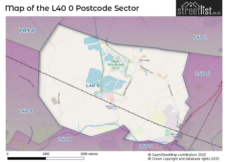
The L40 0 Postcode shares a border with L40 1 (Rufford, Holmeswood), L40 4 (Burscough, Lathom), L40 7 (Burscough), PR9 8 (SOUTHPORT, Banks), L40 5 (Burscough, Lathom), L40 8 (Scarisbrick, Burscough Industrial Estate, Burscough) and L40 9 (Scarisbrick).
The sector is within the post town of ORMSKIRK.
L40 0 is a postcode sector within the L40 postcode district which is within the L Liverpool postcode area.
The Royal Mail delivery office for the L40 0 postal sector is the Ormskirk Delivery Office.
The area of the L40 0 postcode sector is 3.52 square miles which is 9.11 square kilometres or 2,252.12 square acres.
Waterways within the L40 0 postcode sector include the The Sluice, Leeds and Liverpool Canal.

Map of the L40 0 Postcode Sector
Explore the L40 0 postcode sector by using our free interactive map.
| L | 4 | 0 | - | 0 | X | X |
| L | 4 | 0 | Space | 0 | Letter | Letter |
Official List of Streets
Burscough (24 Streets)
Unofficial Streets or Alternative Spellings
Weather Forecast for L40 0
Press Button to Show Forecast for Ormskirk
| Time Period | Icon | Description | Temperature | Rain Probability | Wind |
|---|---|---|---|---|---|
| 21:00 to 00:00 | Cloudy | 11.0°C (feels like 8.0°C) | 10.00% | S 16 mph |
Press Button to Show Forecast for Ormskirk
| Time Period | Icon | Description | Temperature | Rain Probability | Wind |
|---|---|---|---|---|---|
| 00:00 to 03:00 | Cloudy | 10.0°C (feels like 7.0°C) | 10.00% | SSE 16 mph | |
| 03:00 to 06:00 | Cloudy | 10.0°C (feels like 7.0°C) | 7.00% | SE 16 mph | |
| 06:00 to 09:00 | Cloudy | 9.0°C (feels like 6.0°C) | 4.00% | SE 18 mph | |
| 09:00 to 12:00 | Cloudy | 11.0°C (feels like 8.0°C) | 5.00% | SE 18 mph | |
| 12:00 to 15:00 | Cloudy | 14.0°C (feels like 11.0°C) | 8.00% | SSE 18 mph | |
| 15:00 to 18:00 | Cloudy | 15.0°C (feels like 12.0°C) | 13.00% | SSE 16 mph | |
| 18:00 to 21:00 | Cloudy | 13.0°C (feels like 11.0°C) | 15.00% | SSE 11 mph | |
| 21:00 to 00:00 | Overcast | 11.0°C (feels like 10.0°C) | 19.00% | SE 9 mph |
Press Button to Show Forecast for Ormskirk
| Time Period | Icon | Description | Temperature | Rain Probability | Wind |
|---|---|---|---|---|---|
| 00:00 to 03:00 | Cloudy | 10.0°C (feels like 9.0°C) | 9.00% | SE 9 mph | |
| 03:00 to 06:00 | Cloudy | 9.0°C (feels like 7.0°C) | 5.00% | SE 7 mph | |
| 06:00 to 09:00 | Cloudy | 9.0°C (feels like 7.0°C) | 4.00% | SE 7 mph | |
| 09:00 to 12:00 | Cloudy | 11.0°C (feels like 10.0°C) | 5.00% | ESE 7 mph | |
| 12:00 to 15:00 | Cloudy | 14.0°C (feels like 13.0°C) | 7.00% | SSE 7 mph | |
| 15:00 to 18:00 | Cloudy | 14.0°C (feels like 13.0°C) | 10.00% | NW 7 mph | |
| 18:00 to 21:00 | Cloudy | 13.0°C (feels like 12.0°C) | 11.00% | NW 7 mph | |
| 21:00 to 00:00 | Cloudy | 12.0°C (feels like 10.0°C) | 10.00% | NNW 9 mph |
Press Button to Show Forecast for Ormskirk
| Time Period | Icon | Description | Temperature | Rain Probability | Wind |
|---|---|---|---|---|---|
| 00:00 to 03:00 | Cloudy | 11.0°C (feels like 9.0°C) | 11.00% | N 7 mph | |
| 03:00 to 06:00 | Cloudy | 10.0°C (feels like 9.0°C) | 8.00% | N 7 mph | |
| 06:00 to 09:00 | Cloudy | 11.0°C (feels like 9.0°C) | 6.00% | N 7 mph | |
| 09:00 to 12:00 | Partly cloudy (day) | 13.0°C (feels like 11.0°C) | 4.00% | N 9 mph | |
| 12:00 to 15:00 | Sunny day | 15.0°C (feels like 13.0°C) | 3.00% | NNE 11 mph | |
| 15:00 to 18:00 | Partly cloudy (day) | 16.0°C (feels like 14.0°C) | 3.00% | N 11 mph | |
| 18:00 to 21:00 | Sunny day | 15.0°C (feels like 13.0°C) | 3.00% | N 11 mph | |
| 21:00 to 00:00 | Clear night | 12.0°C (feels like 10.0°C) | 3.00% | NNE 11 mph |
Schools and Places of Education Within the L40 0 Postcode Sector
Burscough Bridge Methodist School
Voluntary controlled school
Orrell Lane, Ormskirk, Lancashire, L40 0SG
Head: Mrs L Tyrer
Ofsted Rating: Good
Inspection: 2022-03-23 (768 days ago)
Website: Visit Burscough Bridge Methodist School Website
Phone: 01704892307
Number of Pupils: 43
House Prices in the L40 0 Postcode Sector
| Type of Property | 2018 Average | 2018 Sales | 2017 Average | 2017 Sales | 2016 Average | 2016 Sales | 2015 Average | 2015 Sales |
|---|---|---|---|---|---|---|---|---|
| Detached | £442,500 | 4 | £366,333 | 6 | £336,667 | 3 | £309,167 | 3 |
| Semi-Detached | £197,586 | 11 | £182,167 | 9 | £171,338 | 17 | £167,090 | 10 |
| Terraced | £159,111 | 9 | £111,000 | 7 | £144,583 | 6 | £126,250 | 4 |
| Flats | £0 | 0 | £97,500 | 1 | £0 | 0 | £0 | 0 |
Important Postcodes L40 0 in the Postcode Sector
L40 0RZ is the postcode for Burscough Neighbourhood Centre, Station Approach, and BURSCOUGH YOUTH AND COMMUNITY CENTRE, STATION APPROACH
L40 0SD is the postcode for Burscough Fitness & Racquets Leisure Centre, Mart Lane
L40 0SG is the postcode for Burscough Bridge Methodist School, Orrell Lane
L40 0SW is the postcode for Burscough Sports Centre, Bobby Langton Way, and Burscough Sports Centre, Bobby Langton Way, Burscough
| The L40 0 Sector is within these Local Authorities |
|
|---|---|
| The L40 0 Sector is within these Counties |
|
| The L40 0 Sector is within these Water Company Areas |
|
Tourist Attractions within the L40 0 Postcode Area
We found 1 visitor attractions within the L40 postcode area
| WWT Martin Mere Wetland Centre |
|---|
| Wildlife |
| Safari Park / Zoo / Aquarium / Aviary |
| View WWT Martin Mere Wetland Centre on Google Maps |