The LE9 4 postcode sector is within the county of Leicestershire.
Did you know? According to the 2021 Census, the LE9 4 postcode sector is home to a bustling 8,001 residents!
Given that each sector allows for 400 unique postcode combinations. Letters C, I, K, M, O and V are not allowed in the last two letters of a postcode. With 172 postcodes already in use, this leaves 228 units available.
The largest settlements in the LE9 4 postal code are Stoney Stanton and Sapcote.
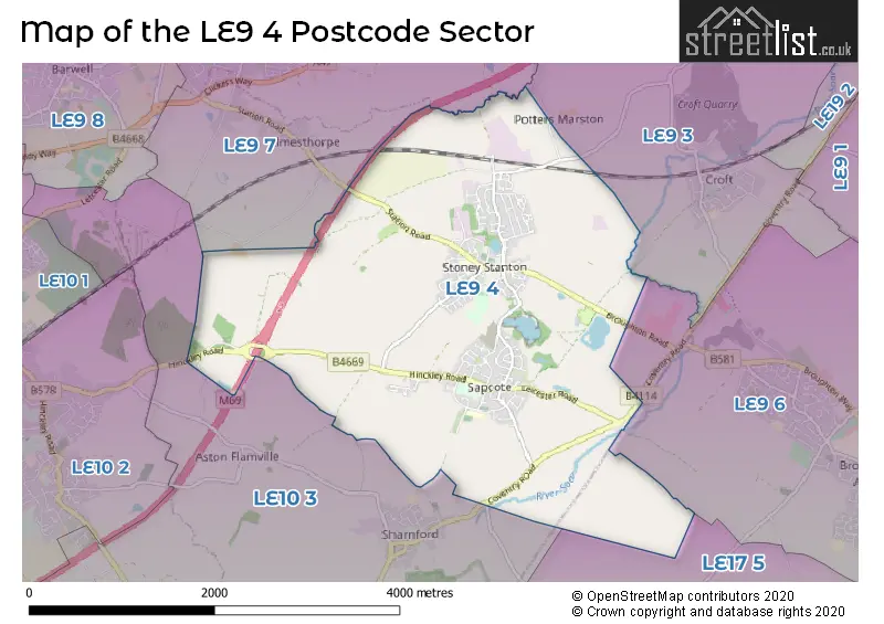
The LE9 4 Postcode shares a border with LE10 3 (HINCKLEY, Wolvey, Sharnford), LE9 3 (Huncote, Croft, Potters Marston), LE9 6 (Broughton Astley), LE9 7 (Earl Shilton, Thurlaston, Elmesthorpe) and LE17 5 (Gilmorton, Ullesthorpe, Dunton Bassett).
The sector is within the post town of LEICESTER.
LE9 4 is a postcode sector within the LE9 postcode district which is within the LE Leicester postcode area.
The Royal Mail delivery office for the LE9 4 postal sector is the Stoney Stanton Scale Payment Delivery Office.
The area of the LE9 4 postcode sector is 5.81 square miles which is 15.06 square kilometres or 3,721.45 square acres.
The LE9 4 postcode sector is crossed by the M69 motorway.
Waterways within the LE9 4 postcode sector include the River Soar.

Map of the LE9 4 Postcode Sector
Explore the LE9 4 postcode sector by using our free interactive map.
| L | E | 9 | - | 4 | X | X |
| L | E | 9 | Space | 4 | Letter | Letter |
Official List of Streets
Stoney Stanton (77 Streets)
Sapcote (65 Streets)
Unofficial Streets or Alternative Spellings
Stoney Stanton
OCCUPATION ROADBroughton Astley
COVENTRY ROADCroft
STANTON LANEElmesthorpe
STANTON ROADFrolesworth
MAIN STREETWeather Forecast for LE9 4
Press Button to Show Forecast for Earl Shilton
| Time Period | Icon | Description | Temperature | Rain Probability | Wind |
|---|---|---|---|---|---|
| 00:00 to 03:00 | Partly cloudy (night) | 14.0°C (feels like 13.0°C) | 0.00% | SE 7 mph | |
| 03:00 to 06:00 | Partly cloudy (night) | 12.0°C (feels like 11.0°C) | 0.00% | ESE 4 mph | |
| 06:00 to 09:00 | Partly cloudy (day) | 12.0°C (feels like 11.0°C) | 1.00% | ESE 7 mph | |
| 09:00 to 12:00 | Partly cloudy (day) | 17.0°C (feels like 16.0°C) | 0.00% | ESE 7 mph | |
| 12:00 to 15:00 | Partly cloudy (day) | 21.0°C (feels like 19.0°C) | 0.00% | SE 9 mph | |
| 15:00 to 18:00 | Cloudy | 22.0°C (feels like 20.0°C) | 3.00% | SE 7 mph | |
| 18:00 to 21:00 | Cloudy | 20.0°C (feels like 19.0°C) | 3.00% | ESE 7 mph | |
| 21:00 to 00:00 | Partly cloudy (night) | 17.0°C (feels like 15.0°C) | 1.00% | ESE 9 mph |
Press Button to Show Forecast for Earl Shilton
| Time Period | Icon | Description | Temperature | Rain Probability | Wind |
|---|---|---|---|---|---|
| 00:00 to 03:00 | Partly cloudy (night) | 13.0°C (feels like 12.0°C) | 1.00% | ESE 9 mph | |
| 03:00 to 06:00 | Cloudy | 12.0°C (feels like 10.0°C) | 3.00% | ESE 7 mph | |
| 06:00 to 09:00 | Cloudy | 13.0°C (feels like 12.0°C) | 4.00% | E 7 mph | |
| 09:00 to 12:00 | Cloudy | 17.0°C (feels like 16.0°C) | 4.00% | ESE 7 mph | |
| 12:00 to 15:00 | Cloudy | 21.0°C (feels like 20.0°C) | 10.00% | SE 9 mph | |
| 15:00 to 18:00 | Cloudy | 21.0°C (feels like 19.0°C) | 16.00% | SSE 9 mph | |
| 18:00 to 21:00 | Light rain shower (day) | 19.0°C (feels like 18.0°C) | 39.00% | SSE 7 mph | |
| 21:00 to 00:00 | Light rain shower (night) | 16.0°C (feels like 15.0°C) | 34.00% | SSE 7 mph |
Press Button to Show Forecast for Earl Shilton
| Time Period | Icon | Description | Temperature | Rain Probability | Wind |
|---|---|---|---|---|---|
| 00:00 to 03:00 | Partly cloudy (night) | 14.0°C (feels like 14.0°C) | 9.00% | S 7 mph | |
| 03:00 to 06:00 | Partly cloudy (night) | 13.0°C (feels like 12.0°C) | 10.00% | S 7 mph | |
| 06:00 to 09:00 | Cloudy | 13.0°C (feels like 11.0°C) | 10.00% | S 9 mph | |
| 09:00 to 12:00 | Cloudy | 15.0°C (feels like 13.0°C) | 11.00% | S 11 mph | |
| 12:00 to 15:00 | Cloudy | 16.0°C (feels like 14.0°C) | 20.00% | S 13 mph | |
| 15:00 to 18:00 | Heavy rain | 16.0°C (feels like 14.0°C) | 75.00% | SSE 13 mph | |
| 18:00 to 21:00 | Light rain | 15.0°C (feels like 13.0°C) | 59.00% | SSE 11 mph | |
| 21:00 to 00:00 | Heavy rain | 13.0°C (feels like 12.0°C) | 76.00% | SSE 11 mph |
Press Button to Show Forecast for Earl Shilton
| Time Period | Icon | Description | Temperature | Rain Probability | Wind |
|---|---|---|---|---|---|
| 00:00 to 03:00 | Light rain | 12.0°C (feels like 11.0°C) | 55.00% | SSE 9 mph | |
| 03:00 to 06:00 | Cloudy | 12.0°C (feels like 10.0°C) | 15.00% | SSE 9 mph | |
| 06:00 to 09:00 | Partly cloudy (day) | 12.0°C (feels like 10.0°C) | 7.00% | SSE 11 mph | |
| 09:00 to 12:00 | Cloudy | 13.0°C (feels like 11.0°C) | 15.00% | SSE 13 mph | |
| 12:00 to 15:00 | Light rain shower (day) | 15.0°C (feels like 12.0°C) | 37.00% | S 13 mph | |
| 15:00 to 18:00 | Light rain shower (day) | 16.0°C (feels like 13.0°C) | 36.00% | S 13 mph | |
| 18:00 to 21:00 | Partly cloudy (day) | 15.0°C (feels like 12.0°C) | 13.00% | S 13 mph | |
| 21:00 to 00:00 | Clear night | 12.0°C (feels like 10.0°C) | 5.00% | S 11 mph |
Schools and Places of Education Within the LE9 4 Postcode Sector
All Saints Church of England Primary School, Sapcote
Academy converter
Bassett Lane, Leicester, Leicestershire, LE9 4FB
Head: Mr Shane Crick
Ofsted Rating: Good
Inspection: 2023-10-12 (212 days ago)
Website: Visit All Saints Church of England Primary School, Sapcote Website
Phone: 01455272973
Number of Pupils: 297
Manorfield Church of England Primary School
Academy converter
Station Road, Leicester, Leicestershire, LE9 4LU
Head: Miss Felicity Clarke (Executive Headteacher), Mrs Ellen Thompson (Head of School)
Ofsted Rating: Good
Inspection: 2023-06-15 (331 days ago)
Website: Visit Manorfield Church of England Primary School Website
Phone: 01455272787
Number of Pupils: 410
House Prices in the LE9 4 Postcode Sector
| Type of Property | 2018 Average | 2018 Sales | 2017 Average | 2017 Sales | 2016 Average | 2016 Sales | 2015 Average | 2015 Sales |
|---|---|---|---|---|---|---|---|---|
| Detached | £284,803 | 111 | £286,643 | 98 | £273,971 | 128 | £278,170 | 91 |
| Semi-Detached | £200,433 | 54 | £188,740 | 59 | £194,551 | 55 | £167,278 | 45 |
| Terraced | £178,322 | 35 | £165,025 | 37 | £158,847 | 20 | £156,950 | 32 |
| Flats | £124,705 | 11 | £112,000 | 6 | £110,900 | 5 | £134,664 | 9 |
Important Postcodes LE9 4 in the Postcode Sector
LE9 4FB is the postcode for All Saints C of E Primary School, Bassett Lane, and All Saints C of E Primary School, Bassett Lane, Sapcote
LE9 4LJ is the postcode for The Old School Surgery, Hinckley Road, Stoney Stanton
LE9 4LU is the postcode for BLOCKS ABC, Manorfield C of E Primary School, Station Road
| The LE9 4 Sector is within these Local Authorities |
|
|---|---|
| The LE9 4 Sector is within these Counties |
|
| The LE9 4 Sector is within these Water Company Areas |
|