The LL13 0 postcode sector stands on the Clwyd and Shropshire border.
Did you know? According to the 2021 Census, the LL13 0 postcode sector is home to a bustling 7,795 residents!
Given that each sector allows for 400 unique postcode combinations. Letters C, I, K, M, O and V are not allowed in the last two letters of a postcode. With 292 postcodes already in use, this leaves 108 units available.
The largest settlement in the LL13 0 postal code is PENLEY followed by Overton, and MARCHWIEL.
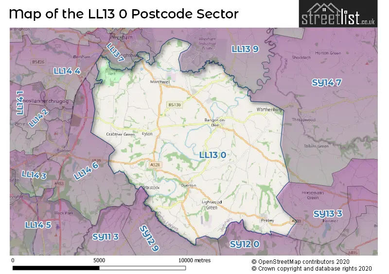
The LL13 0 Postcode shares a border with SY13 3 (BRONINGTON, Tilstock, HANMER), LL13 7 (WREXHAM, WREXHAM TECHNOLOGY PARK), LL13 8 (WREXHAM), LL13 9 (WREXHAM, WREXHAM INDUSTRIAL ESTATE, HOLT), LL14 4 (Rhostyllen, WREXHAM, Bersham), LL14 6 (Ruabon, PEN Y LAN, RHOSYMADOC), SY12 0 (ELLESMERE, Cockshutt, Welshampton), SY12 9 (ELLESMERE, Dudleston Heath, Dudleston) and SY14 7 (Tilston, MALPAS, Threapwood).
The sector is within the post town of WREXHAM.
LL13 0 is a postcode sector within the LL13 postcode district which is within the LL Llandudno postcode area.
The Royal Mail delivery office for the LL13 0 postal sector is the Wrexham Delivery Office.
The area of the LL13 0 postcode sector is 35.08 square miles which is 90.85 square kilometres or 22,449.36 square acres.

Map of the LL13 0 Postcode Sector
Explore the LL13 0 postcode sector by using our free interactive map.
| L | L | 1 | 3 | - | 0 | X | X |
| L | L | 1 | 3 | Space | 0 | Letter | Letter |
Official List of Streets
Bangor-on-Dee (29 Streets)
WREXHAM (24 Streets)
Penley (26 Streets)
Overton (36 Streets)
Cross Lanes (19 Streets)
Gyfelia (2 Streets)
Marchwiel (25 Streets)
Worthenbury (11 Streets)
Unofficial Streets or Alternative Spellings
Hanmer
TARTS HILLELLESMERE
GRANGE ROADWrexham Industrial Estate
ABENBURY WAY CLYWEDOG ROAD NORTH COED ABEN ROADWREXHAM
CEFN ROAD RUABON ROAD SONTLEY ROADNorthwood
LION LANEJohnstown
WREXHAM ROADWeather Forecast for LL13 0
Press Button to Show Forecast for Bangor-On-Dee Racecourse
| Time Period | Icon | Description | Temperature | Rain Probability | Wind |
|---|---|---|---|---|---|
| 06:00 to 09:00 | Cloudy | 5.0°C (feels like 3.0°C) | 8.00% | NE 4 mph | |
| 09:00 to 12:00 | Cloudy | 8.0°C (feels like 6.0°C) | 15.00% | ENE 7 mph | |
| 12:00 to 15:00 | Light rain | 9.0°C (feels like 7.0°C) | 51.00% | NE 9 mph | |
| 15:00 to 18:00 | Cloudy | 9.0°C (feels like 7.0°C) | 54.00% | NE 9 mph | |
| 18:00 to 21:00 | Cloudy | 9.0°C (feels like 7.0°C) | 17.00% | NE 7 mph | |
| 21:00 to 00:00 | Overcast | 7.0°C (feels like 5.0°C) | 10.00% | NNE 7 mph |
Press Button to Show Forecast for Bangor-On-Dee Racecourse
| Time Period | Icon | Description | Temperature | Rain Probability | Wind |
|---|---|---|---|---|---|
| 00:00 to 03:00 | Cloudy | 6.0°C (feels like 3.0°C) | 5.00% | NNE 7 mph | |
| 03:00 to 06:00 | Cloudy | 5.0°C (feels like 2.0°C) | 7.00% | N 9 mph | |
| 06:00 to 09:00 | Cloudy | 6.0°C (feels like 3.0°C) | 10.00% | NNW 9 mph | |
| 09:00 to 12:00 | Cloudy | 8.0°C (feels like 5.0°C) | 12.00% | NNW 9 mph | |
| 12:00 to 15:00 | Cloudy | 10.0°C (feels like 7.0°C) | 14.00% | NW 11 mph | |
| 15:00 to 18:00 | Cloudy | 11.0°C (feels like 8.0°C) | 11.00% | NW 11 mph | |
| 18:00 to 21:00 | Sunny day | 10.0°C (feels like 8.0°C) | 3.00% | W 9 mph | |
| 21:00 to 00:00 | Clear night | 6.0°C (feels like 4.0°C) | 1.00% | SW 7 mph |
Press Button to Show Forecast for Bangor-On-Dee Racecourse
| Time Period | Icon | Description | Temperature | Rain Probability | Wind |
|---|---|---|---|---|---|
| 00:00 to 03:00 | Clear night | 5.0°C (feels like 2.0°C) | 1.00% | S 7 mph | |
| 03:00 to 06:00 | Partly cloudy (night) | 4.0°C (feels like 1.0°C) | 1.00% | S 7 mph | |
| 06:00 to 09:00 | Partly cloudy (day) | 6.0°C (feels like 3.0°C) | 1.00% | SSE 9 mph | |
| 09:00 to 12:00 | Partly cloudy (day) | 11.0°C (feels like 8.0°C) | 2.00% | S 13 mph | |
| 12:00 to 15:00 | Cloudy | 13.0°C (feels like 10.0°C) | 7.00% | S 16 mph | |
| 15:00 to 18:00 | Overcast | 14.0°C (feels like 11.0°C) | 13.00% | S 16 mph | |
| 18:00 to 21:00 | Partly cloudy (day) | 13.0°C (feels like 10.0°C) | 6.00% | SSE 13 mph | |
| 21:00 to 00:00 | Partly cloudy (night) | 10.0°C (feels like 7.0°C) | 2.00% | SSE 11 mph |
Press Button to Show Forecast for Bangor-On-Dee Racecourse
| Time Period | Icon | Description | Temperature | Rain Probability | Wind |
|---|---|---|---|---|---|
| 00:00 to 03:00 | Partly cloudy (night) | 8.0°C (feels like 6.0°C) | 4.00% | SSE 11 mph | |
| 03:00 to 06:00 | Cloudy | 7.0°C (feels like 5.0°C) | 5.00% | SE 9 mph | |
| 06:00 to 09:00 | Partly cloudy (day) | 8.0°C (feels like 6.0°C) | 3.00% | SE 11 mph | |
| 09:00 to 12:00 | Sunny day | 13.0°C (feels like 10.0°C) | 5.00% | SE 13 mph | |
| 12:00 to 15:00 | Partly cloudy (day) | 15.0°C (feels like 12.0°C) | 7.00% | SE 13 mph | |
| 15:00 to 18:00 | Cloudy | 16.0°C (feels like 13.0°C) | 13.00% | SE 13 mph | |
| 18:00 to 21:00 | Cloudy | 15.0°C (feels like 13.0°C) | 10.00% | ESE 9 mph | |
| 21:00 to 00:00 | Cloudy | 12.0°C (feels like 10.0°C) | 7.00% | ESE 9 mph |
House Prices in the LL13 0 Postcode Sector
| Type of Property | 2018 Average | 2018 Sales | 2017 Average | 2017 Sales | 2016 Average | 2016 Sales | 2015 Average | 2015 Sales |
|---|---|---|---|---|---|---|---|---|
| Detached | £272,501 | 62 | £249,272 | 70 | £222,614 | 46 | £232,446 | 71 |
| Semi-Detached | £157,380 | 25 | £148,955 | 27 | £145,829 | 26 | £142,829 | 36 |
| Terraced | £150,587 | 16 | £127,376 | 17 | £125,966 | 25 | £137,166 | 12 |
| Flats | £79,250 | 2 | £71,500 | 1 | £145,000 | 1 | £81,750 | 2 |
Important Postcodes LL13 0 in the Postcode Sector
LL13 0ES is the postcode for St. Marys School, School Lane
LL13 0LU is the postcode for BLOCK 3 AND 4 PENLEY MAELOR HIGH SCHOOL, The Maelor School, Penley, BLOCK 1 AND 2 PENLEY MAELOR HIGH SCHOOL, The Maelor School, Penley, and The Maelor School, Penley
LL13 0SB is the postcode for Ysgol Deiniol, The Ridgeway
LL13 0YD is the postcode for Eyton School, Eyton
| The LL13 0 Sector is within these Local Authorities |
|
|---|---|
| The LL13 0 Sector is within these Counties |
|
| The LL13 0 Sector is within these Water Company Areas |
|
Tourist Attractions within the LL13 0 Postcode Area
We found 1 visitor attractions within the LL13 postcode area
| Erddig |
|---|
| View Erddig on Google Maps |