The LL13 9 postcode sector stands on the Cheshire and Clwyd border.
Did you know? According to the 2021 Census, the LL13 9 postcode sector is home to a bustling 11,663 residents!
Given that each sector allows for 400 unique postcode combinations. Letters C, I, K, M, O and V are not allowed in the last two letters of a postcode. With 328 postcodes already in use, this leaves 72 units available.
The largest settlement in the LL13 9 postal code is WREXHAM followed by WREXHAM INDUSTRIAL ESTATE, and HOLT.
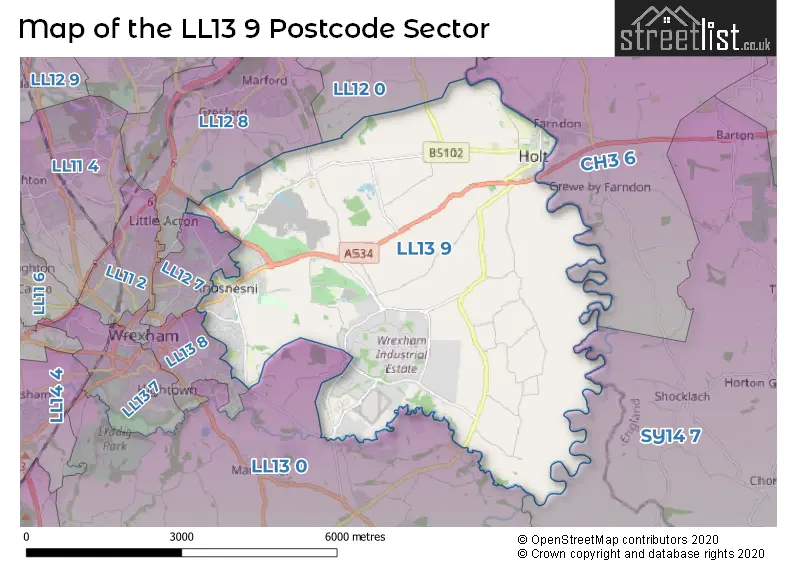
The LL13 9 Postcode shares a border with CH3 6 (Farndon, Saighton, Huntington), LL12 0 (LLAY, ROSSETT, BURTON), LL13 0 (PENLEY, Overton, MARCHWIEL), LL13 8 (WREXHAM), SY14 7 (Tilston, MALPAS, Threapwood), LL12 7 (WREXHAM, ACTON) and LL12 8 (GRESFORD, WREXHAM, MARFORD).
The sector is within the post town of WREXHAM.
LL13 9 is a postcode sector within the LL13 postcode district which is within the LL Llandudno postcode area.
The Royal Mail delivery office for the LL13 9 postal sector is the Wrexham Delivery Office.
The area of the LL13 9 postcode sector is 15.45 square miles which is 40.02 square kilometres or 9,888.76 square acres.

Map of the LL13 9 Postcode Sector
Explore the LL13 9 postcode sector by using our free interactive map.
| L | L | 1 | 3 | - | 9 | X | X |
| L | L | 1 | 3 | Space | 9 | Letter | Letter |
Official List of Streets
Redwither Business Park (7 Streets)
Wrexham Industrial Estate (16 Streets)
WREXHAM (136 Streets)
Holt (36 Streets)
Borras (3 Streets)
Llan-y-Pwll (4 Streets)
Pentre Maelor (6 Streets)
Bowling Bank (3 Streets)
Ridley Wood (2 Streets)
Unofficial Streets or Alternative Spellings
WREXHAM
BORRAS PARK ROAD ERLAS LANE MOORLAND AVENUE NORFOLK ROAD PRINCE CHARLES ROAD QUEENSWAYCross Lanes
BEDWELL ROAD HOLT ROAD SESSWICK WAYMarford
WYNNSTAY LANEGresford
OLD WREXHAM ROADWeather Forecast for LL13 9
Press Button to Show Forecast for Wrexham
| Time Period | Icon | Description | Temperature | Rain Probability | Wind |
|---|---|---|---|---|---|
| 06:00 to 09:00 | Light rain | 5.0°C (feels like 2.0°C) | 61.00% | NNW 11 mph | |
| 09:00 to 12:00 | Light rain | 6.0°C (feels like 3.0°C) | 60.00% | NNW 11 mph | |
| 12:00 to 15:00 | Cloudy | 9.0°C (feels like 5.0°C) | 19.00% | NW 13 mph | |
| 15:00 to 18:00 | Cloudy | 11.0°C (feels like 8.0°C) | 8.00% | WNW 13 mph | |
| 18:00 to 21:00 | Sunny day | 10.0°C (feels like 8.0°C) | 2.00% | W 11 mph | |
| 21:00 to 00:00 | Clear night | 6.0°C (feels like 4.0°C) | 3.00% | SSW 7 mph |
Press Button to Show Forecast for Wrexham
| Time Period | Icon | Description | Temperature | Rain Probability | Wind |
|---|---|---|---|---|---|
| 00:00 to 03:00 | Clear night | 6.0°C (feels like 3.0°C) | 9.00% | SSW 9 mph | |
| 03:00 to 06:00 | Partly cloudy (night) | 6.0°C (feels like 2.0°C) | 2.00% | S 9 mph | |
| 06:00 to 09:00 | Cloudy | 7.0°C (feels like 4.0°C) | 4.00% | S 9 mph | |
| 09:00 to 12:00 | Cloudy | 11.0°C (feels like 8.0°C) | 8.00% | S 16 mph | |
| 12:00 to 15:00 | Cloudy | 13.0°C (feels like 10.0°C) | 13.00% | S 16 mph | |
| 15:00 to 18:00 | Cloudy | 13.0°C (feels like 10.0°C) | 12.00% | S 18 mph | |
| 18:00 to 21:00 | Cloudy | 12.0°C (feels like 9.0°C) | 12.00% | S 16 mph | |
| 21:00 to 00:00 | Cloudy | 10.0°C (feels like 7.0°C) | 7.00% | SSE 13 mph |
Press Button to Show Forecast for Wrexham
| Time Period | Icon | Description | Temperature | Rain Probability | Wind |
|---|---|---|---|---|---|
| 00:00 to 03:00 | Cloudy | 9.0°C (feels like 6.0°C) | 6.00% | SSE 11 mph | |
| 03:00 to 06:00 | Clear night | 8.0°C (feels like 5.0°C) | 3.00% | SSE 11 mph | |
| 06:00 to 09:00 | Partly cloudy (day) | 8.0°C (feels like 5.0°C) | 2.00% | SE 11 mph | |
| 09:00 to 12:00 | Partly cloudy (day) | 12.0°C (feels like 9.0°C) | 2.00% | SE 13 mph | |
| 12:00 to 15:00 | Cloudy | 15.0°C (feels like 12.0°C) | 10.00% | SE 16 mph | |
| 15:00 to 18:00 | Cloudy | 16.0°C (feels like 13.0°C) | 11.00% | SE 13 mph | |
| 18:00 to 21:00 | Partly cloudy (day) | 14.0°C (feels like 12.0°C) | 10.00% | SE 9 mph | |
| 21:00 to 00:00 | Cloudy | 11.0°C (feels like 9.0°C) | 7.00% | ESE 7 mph |
Press Button to Show Forecast for Wrexham
| Time Period | Icon | Description | Temperature | Rain Probability | Wind |
|---|---|---|---|---|---|
| 00:00 to 03:00 | Cloudy | 9.0°C (feels like 7.0°C) | 9.00% | ESE 4 mph | |
| 03:00 to 06:00 | Cloudy | 9.0°C (feels like 8.0°C) | 10.00% | E 4 mph | |
| 06:00 to 09:00 | Light rain | 10.0°C (feels like 9.0°C) | 45.00% | ENE 4 mph | |
| 09:00 to 12:00 | Cloudy | 13.0°C (feels like 12.0°C) | 17.00% | E 7 mph | |
| 12:00 to 15:00 | Light rain | 15.0°C (feels like 14.0°C) | 48.00% | ESE 7 mph | |
| 15:00 to 18:00 | Cloudy | 16.0°C (feels like 15.0°C) | 19.00% | E 7 mph | |
| 18:00 to 21:00 | Cloudy | 15.0°C (feels like 15.0°C) | 13.00% | SE 7 mph | |
| 21:00 to 00:00 | Cloudy | 12.0°C (feels like 11.0°C) | 12.00% | SW 7 mph |
House Prices in the LL13 9 Postcode Sector
| Type of Property | 2018 Average | 2018 Sales | 2017 Average | 2017 Sales | 2016 Average | 2016 Sales | 2015 Average | 2015 Sales |
|---|---|---|---|---|---|---|---|---|
| Detached | £275,957 | 60 | £254,798 | 59 | £224,387 | 54 | £236,244 | 60 |
| Semi-Detached | £144,728 | 41 | £171,717 | 41 | £136,188 | 24 | £171,697 | 30 |
| Terraced | £162,393 | 28 | £131,656 | 25 | £123,392 | 23 | £146,646 | 24 |
| Flats | £76,800 | 5 | £78,500 | 2 | £91,750 | 2 | £52,250 | 2 |
Important Postcodes LL13 9 in the Postcode Sector
LL13 9EF is the postcode for Dean Road Family Centre, Dean Road
LL13 9ET is the postcode for MATHS & ENGLISH BLOCK, Rhosnesni High School, Rhosnesni Lane, Rhosnesni High School, Rhosnesni Lane, SPORTS CENTRE, Rhosnesni High School, Rhosnesni Lane, TECHNOLOGY & LANGUAGES BLOCK, Rhosnesni High School, Rhosnesni Lane, and MAIN HALL, Rhosnesni High School, Rhosnesni Lane
LL13 9HD is the postcode for JUNIOR SCHOOL, Hafod y Wern Junior School, Deva Way, Hafod y Wern Junior School, Deva Way, Hafod Y Wern Community Primary School, Deva Way, INFANT SCHOOL, Hafod y Wern Junior School, Deva Way, and Hafod y Wern Infants School, Deva Way
LL13 9NG is the postcode for LANGUAGES, Ysgol Morgan Llwyd, Cefn Road, SCIENCE, MUSIC AND TECHNOLGY BLOCK, Ysgol Morgan Llwyd, Cefn Road, DRY SPORTS AND LEISURE, Ysgol Morgan Llwyd, Cefn Road, MATHS, LIBRARY, HUMANATIES AND CANTEEN, Ysgol Morgan Llwyd, Cefn Road, and Ysgol Morgan Llwyd, Cefn Road
LL13 9PW is the postcode for Wrexham County Borough Council, Community Service Depot, Abbey Road
LL13 9QE is the postcode for ENTRY BUILDING, H M P Berwyn, 139 Bridge Road, and SUPPORT BUILDING, H M P Berwyn, 139 Bridge Road
LL13 9SQ is the postcode for Abenbury Community Centre, Bridge Road
LL13 9TP is the postcode for Barker's Lane Community School, Barker's Lane
LL13 9TY is the postcode for Erlas Centre, Bryn Estyn Business Centre, Bryn Estyn Road, and Wrexham County Borough Council, Erlas House, Bryn Estyn Road
| The LL13 9 Sector is within these Local Authorities |
|
|---|---|
| The LL13 9 Sector is within these Counties |
|
| The LL13 9 Sector is within these Water Company Areas |
|