The LL23 7 postcode sector lies where the three counties of Clwyd, Gwynedd, and Powys meet.
Did you know? According to the 2021 Census, the LL23 7 postcode sector is home to a bustling 4,220 residents!
Given that each sector allows for 400 unique postcode combinations. Letters C, I, K, M, O and V are not allowed in the last two letters of a postcode. With 198 postcodes already in use, this leaves 202 units available.
The largest settlement in the LL23 7 postal code is Y BALA followed by LLANUWCHLLYN, and LLANDDERFEL.
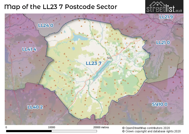
The LL23 7 Postcode shares a border with SY10 0 (LLANRHAEADR-YM-MOCHNANT, LLANGYNOG, LLANWDDYN), LL21 0 (CORWEN, LLANDRILLO, CYNWYD), LL24 0 (BETWS Y COED, PENMACHNO, PENTREFOELAS), LL40 2 (DOLGELLAU, LLANFACHRETH, LLANELLTYD), LL41 4 (TRAWSFYNYDD, LLAN FFESTINIOG, MANOD) and SY20 9 (PENNAL, CORRIS, DINAS MAWDDWY).
The sector is within the post town of BALA.
LL23 7 is a postcode sector within the LL23 postcode district which is within the LL Llandudno postcode area.
The Royal Mail delivery office for the LL23 7 postal sector is the Bala Delivery Office.
The area of the LL23 7 postcode sector is 144.26 square miles which is 373.63 square kilometres or 92,325.45 square acres.

Map of the LL23 7 Postcode Sector
Explore the LL23 7 postcode sector by using our free interactive map.
| L | L | 2 | 3 | - | 7 | X | X |
| L | L | 2 | 3 | Space | 7 | Letter | Letter |
Official List of Streets
BALA (41 Streets)
Llandderfel (7 Streets)
Llanuwchllyn (5 Streets)
Sarnau (1 Streets)
Unofficial Streets or Alternative Spellings
Weather Forecast for LL23 7
Press Button to Show Forecast for Llyn Tegid
| Time Period | Icon | Description | Temperature | Rain Probability | Wind |
|---|---|---|---|---|---|
| 00:00 to 03:00 | Cloudy | 4.0°C (feels like 2.0°C) | 8.00% | ENE 4 mph | |
| 03:00 to 06:00 | Cloudy | 4.0°C (feels like 2.0°C) | 9.00% | ENE 7 mph | |
| 06:00 to 09:00 | Cloudy | 5.0°C (feels like 3.0°C) | 12.00% | ENE 7 mph | |
| 09:00 to 12:00 | Cloudy | 7.0°C (feels like 4.0°C) | 10.00% | E 9 mph | |
| 12:00 to 15:00 | Light rain | 7.0°C (feels like 5.0°C) | 51.00% | ENE 9 mph | |
| 15:00 to 18:00 | Cloudy | 8.0°C (feels like 5.0°C) | 18.00% | NE 9 mph | |
| 18:00 to 21:00 | Overcast | 8.0°C (feels like 5.0°C) | 13.00% | NE 9 mph | |
| 21:00 to 00:00 | Cloudy | 6.0°C (feels like 4.0°C) | 9.00% | NE 7 mph |
Press Button to Show Forecast for Llyn Tegid
| Time Period | Icon | Description | Temperature | Rain Probability | Wind |
|---|---|---|---|---|---|
| 00:00 to 03:00 | Cloudy | 5.0°C (feels like 2.0°C) | 6.00% | NE 7 mph | |
| 03:00 to 06:00 | Cloudy | 4.0°C (feels like 1.0°C) | 5.00% | NNE 7 mph | |
| 06:00 to 09:00 | Cloudy | 5.0°C (feels like 2.0°C) | 10.00% | N 7 mph | |
| 09:00 to 12:00 | Cloudy | 8.0°C (feels like 5.0°C) | 11.00% | NNW 9 mph | |
| 12:00 to 15:00 | Partly cloudy (day) | 9.0°C (feels like 7.0°C) | 10.00% | NW 11 mph | |
| 15:00 to 18:00 | Partly cloudy (day) | 10.0°C (feels like 7.0°C) | 6.00% | WNW 11 mph | |
| 18:00 to 21:00 | Sunny day | 9.0°C (feels like 7.0°C) | 2.00% | W 9 mph | |
| 21:00 to 00:00 | Clear night | 6.0°C (feels like 3.0°C) | 1.00% | SW 7 mph |
Press Button to Show Forecast for Llyn Tegid
| Time Period | Icon | Description | Temperature | Rain Probability | Wind |
|---|---|---|---|---|---|
| 00:00 to 03:00 | Clear night | 6.0°C (feels like 3.0°C) | 1.00% | SSW 9 mph | |
| 03:00 to 06:00 | Cloudy | 6.0°C (feels like 3.0°C) | 7.00% | SSW 9 mph | |
| 06:00 to 09:00 | Cloudy | 7.0°C (feels like 4.0°C) | 8.00% | S 11 mph | |
| 09:00 to 12:00 | Cloudy | 10.0°C (feels like 8.0°C) | 6.00% | S 13 mph | |
| 12:00 to 15:00 | Overcast | 12.0°C (feels like 9.0°C) | 12.00% | S 16 mph | |
| 15:00 to 18:00 | Cloudy | 12.0°C (feels like 9.0°C) | 12.00% | S 16 mph | |
| 18:00 to 21:00 | Cloudy | 11.0°C (feels like 9.0°C) | 10.00% | SSE 11 mph | |
| 21:00 to 00:00 | Partly cloudy (night) | 9.0°C (feels like 7.0°C) | 4.00% | SSE 11 mph |
Press Button to Show Forecast for Llyn Tegid
| Time Period | Icon | Description | Temperature | Rain Probability | Wind |
|---|---|---|---|---|---|
| 00:00 to 03:00 | Cloudy | 8.0°C (feels like 5.0°C) | 9.00% | SSE 11 mph | |
| 03:00 to 06:00 | Cloudy | 7.0°C (feels like 5.0°C) | 8.00% | SE 11 mph | |
| 06:00 to 09:00 | Cloudy | 8.0°C (feels like 5.0°C) | 8.00% | SE 11 mph | |
| 09:00 to 12:00 | Partly cloudy (day) | 11.0°C (feels like 8.0°C) | 6.00% | SE 13 mph | |
| 12:00 to 15:00 | Partly cloudy (day) | 14.0°C (feels like 11.0°C) | 9.00% | SE 16 mph | |
| 15:00 to 18:00 | Cloudy | 15.0°C (feels like 12.0°C) | 13.00% | SE 13 mph | |
| 18:00 to 21:00 | Cloudy | 13.0°C (feels like 12.0°C) | 8.00% | SE 9 mph | |
| 21:00 to 00:00 | Cloudy | 10.0°C (feels like 8.0°C) | 7.00% | ESE 7 mph |
House Prices in the LL23 7 Postcode Sector
| Type of Property | 2018 Average | 2018 Sales | 2017 Average | 2017 Sales | 2016 Average | 2016 Sales | 2015 Average | 2015 Sales |
|---|---|---|---|---|---|---|---|---|
| Detached | £232,657 | 14 | £227,672 | 29 | £225,750 | 26 | £210,360 | 25 |
| Semi-Detached | £128,313 | 8 | £162,679 | 7 | £145,667 | 6 | £148,333 | 6 |
| Terraced | £105,563 | 24 | £93,708 | 18 | £88,197 | 33 | £81,064 | 22 |
| Flats | £0 | 0 | £0 | 0 | £0 | 0 | £0 | 0 |
Important Postcodes LL23 7 in the Postcode Sector
LL23 7AD is the postcode for Ye Olde Bulls Head, 78 High Street
LL23 7BA is the postcode for Hafan Clinic
LL23 7HE is the postcode for Ysgol Ffridd y Llyn, Cefn Ddwysarn
LL23 7NT is the postcode for Ysgol Bro Tryweryn, Fron Goch
LL23 7RU is the postcode for Ysgol y Godre'r y Berwyn, Ffrydan Road, TECHNOLOGY BLOCK, Ysgol y Berwyn, Ffrydan Road, and Ysgol y Berwyn, Ffrydan Road
LL23 7SR is the postcode for Penllyn Leisure Centre, Pensarn Road
| The LL23 7 Sector is within these Local Authorities |
|
|---|---|
| The LL23 7 Sector is within these Counties |
|
| The LL23 7 Sector is within these Water Company Areas |
|
Tourist Attractions within the LL23 7 Postcode Area
We found 1 visitor attractions within the LL23 postcode area
| Byd Mary Jones |
|---|
| View Byd Mary Jones on Google Maps |