The LS11 9 postcode sector is within the county of West Yorkshire.
Did you know? According to the 2021 Census, the LS11 9 postcode sector is home to a bustling 4,155 residents!
Given that each sector allows for 400 unique postcode combinations. Letters C, I, K, M, O and V are not allowed in the last two letters of a postcode. With 123 postcodes already in use, this leaves 277 units available.
The LS11 9 postal code covers the settlement of LEEDS.
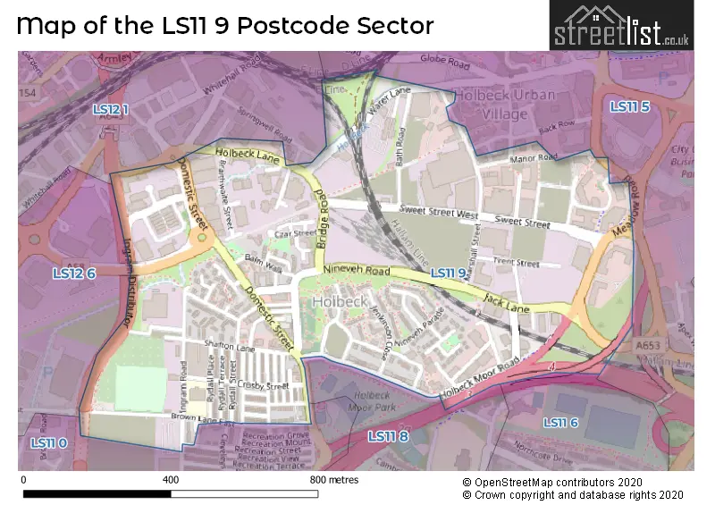
The LS11 9 Postcode shares a border with LS12 6 (LEEDS, Lower Wortley, New Farnley), LS11 5 (LEEDS, Holbeck), LS11 6 (LEEDS), LS11 8 (LEEDS, Beeston), LS12 1 (LEEDS, Armley) and LS11 0 (LEEDS).
The sector is within the post town of LEEDS.
LS11 9 is a postcode sector within the LS1 postcode district which is within the LS Leeds postcode area.
The Royal Mail delivery office for the LS11 9 postal sector is the unknown.
The area of the LS11 9 postcode sector is 0.39 square miles which is 1.01 square kilometres or 249.94 square acres.
The LS11 9 postcode sector is crossed by the M621 motorway.
Waterways within the LS11 9 postcode sector include the Hol Beck.

Map of the LS11 9 Postcode Sector
Explore the LS11 9 postcode sector by using our free interactive map.
| L | S | 1 | 1 | - | 9 | X | X |
| L | S | 1 | 1 | Space | 9 | Letter | Letter |
Official List of Streets
LEEDS (71 Streets)
Unofficial Streets or Alternative Spellings
LEEDS
BRIDGE COURT BUTCHER STREET CLEVELEYS AVENUE COLENSO MOUNT DAVID STREET DERWENT VIEW DOMESTIC ROAD LEODIS COURT SPRINGWELL COURT SPRINGWELL ROAD SPRINGWELL VIEW WORTLEY LANE COLENSO GARDENS CRESKELL ROAD CROSSLAND COURT CROSSLAND STREET DERWENT PLACE FOURTH COURT HOLBECK SUBWAY INGRAM DISTRIBUTOR INGRAM VIEW LOW HALL PLACE MARSHALL COURT MEADOW CROFT PLEASANT GROVE PLEASANT STREET SIDDAL STREET SILVER STREET ST BARNABAS ROAD TRENT STREET UNION PLACE WALTON STREETMorley
DEWSBURY ROADHolbeck
VICTORIA ROADSchools and Places of Education Within the LS11 9 Postcode Sector
Ingram Road Primary School
Community school
Brown Lane East, Leeds, West Yorkshire, LS11 9LA
Head: Miss Sarah Millard
Ofsted Rating: Requires improvement
Inspection: 2020-02-27 (1547 days ago)
Website: Visit Ingram Road Primary School Website
Phone: 01132456136
Number of Pupils: 349
House Prices in the LS11 9 Postcode Sector
| Type of Property | 2018 Average | 2018 Sales | 2017 Average | 2017 Sales | 2016 Average | 2016 Sales | 2015 Average | 2015 Sales |
|---|---|---|---|---|---|---|---|---|
| Detached | £0 | 0 | £114,000 | 2 | £0 | 0 | £0 | 0 |
| Semi-Detached | £116,000 | 3 | £64,750 | 2 | £52,000 | 1 | £99,333 | 3 |
| Terraced | £71,321 | 19 | £72,928 | 18 | £65,475 | 28 | £55,800 | 15 |
| Flats | £129,804 | 28 | £139,005 | 49 | £127,639 | 44 | £95,673 | 106 |
Important Postcodes LS11 9 in the Postcode Sector
LS11 9AT is the postcode for Lateral, 8 City Walk, Environment Agency, Lateral, 8 City Walk, Department for Communities and Local Government, Lateral, GROUND FLOOR, 1ST FLOOR AND 2ND FLOOR, Department for Communities and Local Government, Lateral, and Lateral, 8, City Walk
LS11 9BH is the postcode for The Lowell Group, Enterprise House, 1 Apex View
LS11 9DA is the postcode for The Insolvency Service, 1 City Walk, and The Insolvency Service, 3rd Floor, 1, City Walk
LS11 9LA is the postcode for Ingram Road Primary School, Brown Lane East, and Ingram Road Primary School, Brown Lane East, Holbeck
LS11 9ND is the postcode for Royal Mail, Holbeck Delivery Office, New Princess Street
LS11 9NR is the postcode for St. Matthews Community Centre, St. Matthews Street
LS11 9RZ is the postcode for Leeds Youth Offending Team, 47 Marshall Street
LS11 9YJ is the postcode for Health & Safety Executive, Marshall Mills, Marshall Street
| The LS11 9 Sector is within these Local Authorities |
|
|---|---|
| The LS11 9 Sector is within these Counties |
|
| The LS11 9 Sector is within these Water Company Areas |
|