The LU2 postcode district is a postal district located in the LU Luton postcode area with a population of 61,617 residents according to the 2021 England and Wales Census.
The area of the LU2 postcode district is 20.66 square miles which is 53.52 square kilometres or 13,225.41 acres.
Currently, the LU2 district has about 980 postcode units spread across 4 geographic postcode sectors.
Given that each sector allows for 400 unique postcode combinations, the district has a capacity of 1,600 postcodes. With 980 postcodes already in use, this leaves 620 units available.
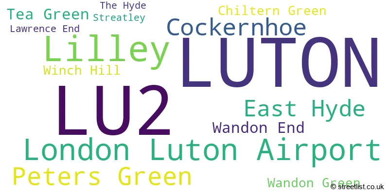
The largest settlement in the LU2 postal code is LUTON followed by Lilley, and London Luton Airport.
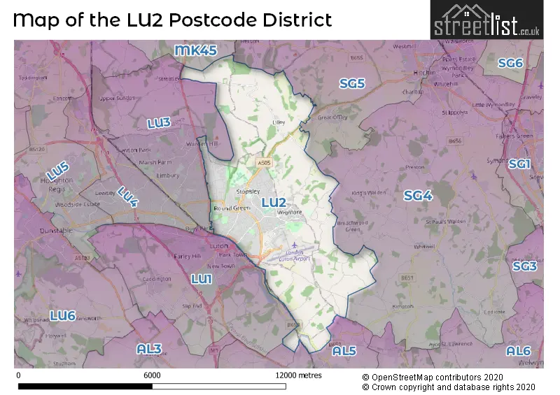
The LU2 Postcode shares a border with AL5 (HARPENDEN), LU1 (LUTON, Caddington, Slip End), LU3 (LUTON, Sundon), SG4 (HITCHIN, Codicote, Kimpton), SG5 (HITCHIN, Stotfold, Fairfield) and MK45 (Flitwick, Ampthill, Barton-le-Clay).
In the LU2 postcode district in Bedfordshire, the primary settlement is Luton. Other significant settlements in the district include Cockernhoe, Lawrence End, Lilley, Peters Green, Streatley, Tea Green, Wandon End, Wandon Green, and Winch Hill. The county in which these settlements are located is Bedfordshire. The most significant post town in the district is Luton.
For the district LU2, we have data on 4 postcode sectors. Here's a breakdown: The sector LU2 0, covers Luton in Bedfordshire. The sector LU2 7, covers Luton in Bedfordshire. The sector LU2 8, covers Luton in Bedfordshire. The sector LU2 9, covers Luton in Bedfordshire.

Map of the LU2 Postcode District
Explore the LU2 postcode district by using our free interactive map.
When it comes to local government, postal geography often disregards political borders. However, for a breakdown in the LU2 District: the district mostly encompasses the Luton (B) (903 postcodes), followed by the North Hertfordshire District area (64 postcodes), followed by the Central Bedfordshire area (31 postcodes), and finally, the St. Albans District (B) area (3 postcodes).
Recent House Sales in LU2
| Date | Price | Address |
|---|---|---|
| 09/10/2023 | £105,000 | Felton Close, Luton, LU2 9TD |
| 06/10/2023 | £313,000 | Roedean Close, Luton, LU2 8QW |
| 29/09/2023 | £355,000 | Wren Close, Luton, LU2 8EY |
| 29/09/2023 | £310,000 | Long Close, Luton, LU2 9BJ |
| 26/09/2023 | £580,000 | Wendover Way, Luton, LU2 7LS |
| 22/09/2023 | £342,000 | Porlock Drive, Luton, LU2 9LL |
| 18/09/2023 | £200,000 | High Town Road, Luton, LU2 0FJ |
| 14/09/2023 | £360,000 | Wigmore Lane, Luton, LU2 8AA |
| 12/09/2023 | £265,000 | Farmbrook, Luton, LU2 7SQ |
| 11/09/2023 | £580,000 | Sherborne Avenue, Luton, LU2 7BD |
Weather Forecast for LU2
Press Button to Show Forecast for Hart Hill
| Time Period | Icon | Description | Temperature | Rain Probability | Wind |
|---|---|---|---|---|---|
| 06:00 to 09:00 | Heavy rain | 5.0°C (feels like 2.0°C) | 78.00% | NE 9 mph | |
| 09:00 to 12:00 | Light rain | 6.0°C (feels like 3.0°C) | 48.00% | NE 11 mph | |
| 12:00 to 15:00 | Overcast | 8.0°C (feels like 5.0°C) | 28.00% | NE 11 mph | |
| 15:00 to 18:00 | Cloudy | 9.0°C (feels like 7.0°C) | 13.00% | NE 9 mph | |
| 18:00 to 21:00 | Overcast | 9.0°C (feels like 6.0°C) | 20.00% | NNE 11 mph | |
| 21:00 to 00:00 | Light rain | 7.0°C (feels like 5.0°C) | 63.00% | NNE 11 mph |
Press Button to Show Forecast for Hart Hill
| Time Period | Icon | Description | Temperature | Rain Probability | Wind |
|---|---|---|---|---|---|
| 00:00 to 03:00 | Heavy rain | 7.0°C (feels like 4.0°C) | 89.00% | NNE 11 mph | |
| 03:00 to 06:00 | Heavy rain | 7.0°C (feels like 3.0°C) | 88.00% | NNE 11 mph | |
| 06:00 to 09:00 | Heavy rain | 7.0°C (feels like 4.0°C) | 90.00% | NNW 11 mph | |
| 09:00 to 12:00 | Heavy rain | 7.0°C (feels like 5.0°C) | 84.00% | NW 9 mph | |
| 12:00 to 15:00 | Light rain | 8.0°C (feels like 5.0°C) | 57.00% | NW 11 mph | |
| 15:00 to 18:00 | Overcast | 9.0°C (feels like 7.0°C) | 22.00% | W 9 mph | |
| 18:00 to 21:00 | Cloudy | 9.0°C (feels like 7.0°C) | 10.00% | W 7 mph | |
| 21:00 to 00:00 | Partly cloudy (night) | 7.0°C (feels like 5.0°C) | 4.00% | SW 7 mph |
Press Button to Show Forecast for Hart Hill
| Time Period | Icon | Description | Temperature | Rain Probability | Wind |
|---|---|---|---|---|---|
| 00:00 to 03:00 | Clear night | 6.0°C (feels like 4.0°C) | 3.00% | SW 7 mph | |
| 03:00 to 06:00 | Clear night | 5.0°C (feels like 2.0°C) | 2.00% | SSW 7 mph | |
| 06:00 to 09:00 | Sunny day | 6.0°C (feels like 3.0°C) | 1.00% | S 7 mph | |
| 09:00 to 12:00 | Partly cloudy (day) | 11.0°C (feels like 8.0°C) | 1.00% | S 11 mph | |
| 12:00 to 15:00 | Cloudy | 13.0°C (feels like 10.0°C) | 9.00% | S 11 mph | |
| 15:00 to 18:00 | Partly cloudy (day) | 14.0°C (feels like 11.0°C) | 3.00% | S 11 mph | |
| 18:00 to 21:00 | Sunny day | 13.0°C (feels like 10.0°C) | 2.00% | S 9 mph | |
| 21:00 to 00:00 | Clear night | 9.0°C (feels like 7.0°C) | 2.00% | SSE 7 mph |
Press Button to Show Forecast for Hart Hill
| Time Period | Icon | Description | Temperature | Rain Probability | Wind |
|---|---|---|---|---|---|
| 00:00 to 03:00 | Clear night | 8.0°C (feels like 6.0°C) | 2.00% | SE 7 mph | |
| 03:00 to 06:00 | Clear night | 7.0°C (feels like 5.0°C) | 4.00% | SE 7 mph | |
| 06:00 to 09:00 | Sunny day | 8.0°C (feels like 6.0°C) | 4.00% | SE 7 mph | |
| 09:00 to 12:00 | Cloudy | 12.0°C (feels like 10.0°C) | 8.00% | SE 9 mph | |
| 12:00 to 15:00 | Cloudy | 15.0°C (feels like 13.0°C) | 12.00% | SE 11 mph | |
| 15:00 to 18:00 | Cloudy | 16.0°C (feels like 14.0°C) | 13.00% | SE 9 mph | |
| 18:00 to 21:00 | Partly cloudy (day) | 14.0°C (feels like 13.0°C) | 8.00% | SE 9 mph | |
| 21:00 to 00:00 | Cloudy | 11.0°C (feels like 10.0°C) | 9.00% | ESE 7 mph |
Where is the LU2 Postcode District?
The data shows that the postcode district LU2 is located in Luton, which is a town in the United Kingdom. Luton is not far from several nearby towns. To the North East of Luton, there is Hitchin, which is approximately 5.01 miles away. To the South, there is Harpenden, which is approximately 5.27 miles away. To the West, there is Dunstable, which is approximately 6.39 miles away. To the East, there is Stevenage, which is approximately 8.09 miles away. Additionally, Welwyn is located to the South East of Luton, approximately 8.76 miles away. It is important to note that Luton is also approximately 28.94 miles from the centre of London.
The district is within the post town of LUTON.
The sector has postcodes within the nation of England.
The LU2 Postcode District is covers the following regions.
- Luton - Bedfordshire and Hertfordshire - East of England
- Central Bedfordshire - Bedfordshire and Hertfordshire - East of England
- Hertfordshire - Bedfordshire and Hertfordshire - East of England
| Postcode Sector | Delivery Office |
|---|---|
| LU2 0 | Luton Delivery Office |
| LU2 7 | Luton Delivery Office |
| LU2 8 | Luton Delivery Office |
| LU2 9 | Luton Delivery Office |
| L | U | 2 | - | X | X | X |
| L | U | 2 | Space | Numeric | Letter | Letter |
Current Monthly Rental Prices
| # Bedrooms | Min Price | Max Price | Avg Price |
|---|---|---|---|
| £275 | £1,255 | £1,036 | |
| 1 | £500 | £1,390 | £993 |
| 2 | £1,000 | £1,665 | £1,272 |
| 3 | £1,300 | £11,395 | £2,363 |
| 4 | £1,450 | £2,500 | £1,984 |
| 6 | £3,000 | £3,000 | £3,000 |
Current House Prices
| # Bedrooms | Min Price | Max Price | Avg Price |
|---|---|---|---|
| £85,000 | £5,000,000 | £716,994 | |
| 1 | £110,000 | £260,000 | £179,856 |
| 2 | £82,000 | £399,995 | £259,738 |
| 3 | £190,000 | £725,000 | £364,531 |
| 4 | £350,000 | £1,250,000 | £534,677 |
| 5 | £350,000 | £2,750,000 | £861,000 |
| 6 | £450,000 | £1,350,000 | £783,333 |
| 7 | £400,000 | £400,000 | £400,000 |
Estate Agents who Operate in the LU2 District
| Logo | Name | Brand Name | Address | Contact Number | Total Properties |
|---|---|---|---|---|---|
 | Luton | Penrose Estate Agents | 386 Hitchin Road Luton LU2 7SR | 01582 377827 | 35 |
 | Stopsley | Connells | Jansel House Parade, 656 Hitchin Road, Stopsley, Luton , LU2 7XH | 01582 377424 | 32 |
 | Stopsley | Urban & Rural Property Services | 593 Hitchin Road, Stopsley, Luton, LU2 7UN | 01582 377607 | 28 |
 | SW8 | Strawberry Star | 157 - 159 Wandsworth Road London SW8 2LY | 020 3834 8495 | 25 |
 | Stopsley | Indigo Residential | 626 Hitchin Road, Luton, LU2 7UG | 01582 297278 | 25 |
| Type of Property | 2018 Average | 2018 Sales | 2017 Average | 2017 Sales | 2016 Average | 2016 Sales | 2015 Average | 2015 Sales |
|---|---|---|---|---|---|---|---|---|
| Detached | £409,657 | 156 | £393,416 | 142 | £382,939 | 124 | £336,895 | 165 |
| Semi-Detached | £295,691 | 340 | £283,256 | 399 | £267,524 | 355 | £236,953 | 377 |
| Terraced | £243,235 | 238 | £244,759 | 258 | £223,872 | 313 | £193,624 | 310 |
| Flats | £172,032 | 159 | £157,450 | 174 | £143,213 | 233 | £126,321 | 160 |