The AL5 postcode district is a postal district located in the AL St Albans postcode area with a population of 31,674 residents according to the 2021 England and Wales Census.
The area of the AL5 postcode district is 11.34 square miles which is 29.36 square kilometres or 7,256.10 acres.
Currently, the AL5 district has about 1061 postcode units spread across 5 geographic postcode sectors.
Given that each sector allows for 400 unique postcode combinations, the district has a capacity of 2,000 postcodes. With 1061 postcodes already in use, this leaves 939 units available.
The AL5 postal code covers the settlement of HARPENDEN.
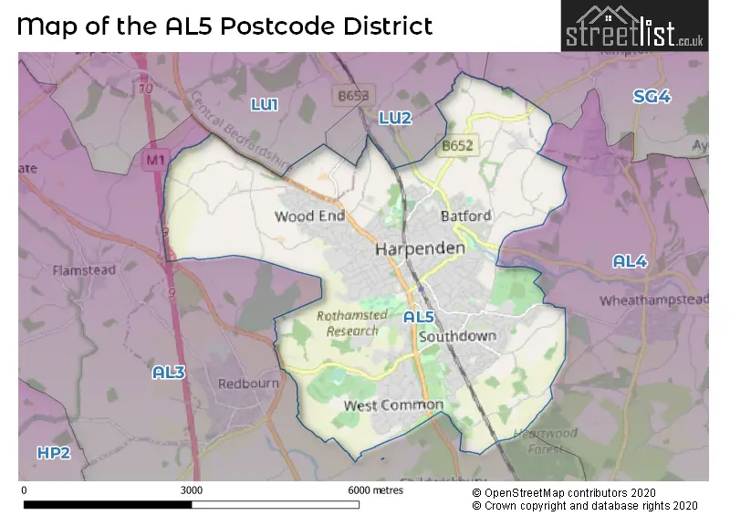
The AL5 Postcode shares a border with AL3 (ST. ALBANS, Redbourn, Markyate), AL4 (ST. ALBANS, Wheathampstead, Sandridge), LU1 (LUTON, Caddington, Slip End), LU2 (LUTON, Lilley, London Luton Airport) and SG4 (HITCHIN, Codicote, Kimpton).
The primary settlement in the AL5 postcode district is Harpenden, located in the county of Hertfordshire, England. Other significant settlements in this district include Kinsbourne Green and Bower Heath. The main post town for this district is Harpenden.
For the district AL5, we have data on 6 postcode sectors. Here's a breakdown: The sector AL5 1, covers Harpenden in Hertfordshire. The sector AL5 2, covers Harpenden in Hertfordshire. The sector AL5 3, covers Harpenden in Hertfordshire. The sector AL5 4, covers Harpenden in Hertfordshire. The sector AL5 5, covers Harpenden in Hertfordshire. The sector AL5 9 is non-geographic. It's often designated for PO Boxes, large organisations, or special services.


Map of the AL5 Postcode District
Explore the AL5 postcode district by using our free interactive map.
When it comes to local government, postal geography often disregards political borders. However, for a breakdown in the AL5 District: the district mostly encompasses the St. Albans District (B) (1057 postcodes), and finally, the Central Bedfordshire area (3 postcodes).
Weather Forecast for AL5
Press Button to Show Forecast for Harpenden
| Time Period | Icon | Description | Temperature | Rain Probability | Wind |
|---|---|---|---|---|---|
| 12:00 to 15:00 | Overcast | 9.0°C (feels like 6.0°C) | 15.00% | NE 9 mph | |
| 15:00 to 18:00 | Cloudy | 11.0°C (feels like 8.0°C) | 10.00% | NNE 11 mph | |
| 18:00 to 21:00 | Cloudy | 10.0°C (feels like 7.0°C) | 57.00% | NE 11 mph | |
| 21:00 to 00:00 | Light rain | 8.0°C (feels like 5.0°C) | 61.00% | NNE 11 mph |
Press Button to Show Forecast for Harpenden
| Time Period | Icon | Description | Temperature | Rain Probability | Wind |
|---|---|---|---|---|---|
| 00:00 to 03:00 | Heavy rain | 7.0°C (feels like 4.0°C) | 85.00% | NNE 11 mph | |
| 03:00 to 06:00 | Heavy rain | 7.0°C (feels like 4.0°C) | 87.00% | NNE 11 mph | |
| 06:00 to 09:00 | Heavy rain | 7.0°C (feels like 4.0°C) | 89.00% | NNW 9 mph | |
| 09:00 to 12:00 | Heavy rain | 8.0°C (feels like 6.0°C) | 83.00% | NW 9 mph | |
| 12:00 to 15:00 | Light rain | 9.0°C (feels like 7.0°C) | 56.00% | WNW 9 mph | |
| 15:00 to 18:00 | Overcast | 10.0°C (feels like 7.0°C) | 22.00% | W 9 mph | |
| 18:00 to 21:00 | Cloudy | 9.0°C (feels like 7.0°C) | 10.00% | W 7 mph | |
| 21:00 to 00:00 | Cloudy | 7.0°C (feels like 5.0°C) | 7.00% | SW 7 mph |
Press Button to Show Forecast for Harpenden
| Time Period | Icon | Description | Temperature | Rain Probability | Wind |
|---|---|---|---|---|---|
| 00:00 to 03:00 | Clear night | 6.0°C (feels like 4.0°C) | 3.00% | SW 7 mph | |
| 03:00 to 06:00 | Clear night | 5.0°C (feels like 3.0°C) | 2.00% | SW 4 mph | |
| 06:00 to 09:00 | Sunny day | 6.0°C (feels like 4.0°C) | 1.00% | S 7 mph | |
| 09:00 to 12:00 | Partly cloudy (day) | 11.0°C (feels like 9.0°C) | 1.00% | SSW 9 mph | |
| 12:00 to 15:00 | Cloudy | 13.0°C (feels like 11.0°C) | 6.00% | S 11 mph | |
| 15:00 to 18:00 | Partly cloudy (day) | 14.0°C (feels like 11.0°C) | 3.00% | S 13 mph | |
| 18:00 to 21:00 | Sunny day | 12.0°C (feels like 10.0°C) | 2.00% | S 9 mph | |
| 21:00 to 00:00 | Clear night | 9.0°C (feels like 7.0°C) | 2.00% | SSE 7 mph |
Press Button to Show Forecast for Harpenden
| Time Period | Icon | Description | Temperature | Rain Probability | Wind |
|---|---|---|---|---|---|
| 00:00 to 03:00 | Clear night | 8.0°C (feels like 6.0°C) | 3.00% | SE 7 mph | |
| 03:00 to 06:00 | Clear night | 7.0°C (feels like 5.0°C) | 5.00% | ESE 7 mph | |
| 06:00 to 09:00 | Partly cloudy (day) | 8.0°C (feels like 7.0°C) | 5.00% | ESE 7 mph | |
| 09:00 to 12:00 | Partly cloudy (day) | 13.0°C (feels like 11.0°C) | 6.00% | SE 9 mph | |
| 12:00 to 15:00 | Cloudy | 15.0°C (feels like 13.0°C) | 13.00% | SE 11 mph | |
| 15:00 to 18:00 | Cloudy | 15.0°C (feels like 14.0°C) | 14.00% | SE 9 mph | |
| 18:00 to 21:00 | Partly cloudy (day) | 14.0°C (feels like 13.0°C) | 10.00% | SE 9 mph | |
| 21:00 to 00:00 | Cloudy | 12.0°C (feels like 10.0°C) | 11.00% | ESE 7 mph |
Where is the AL5 Postcode District?
The postcode district AL5 is located in Harpenden. Harpenden is situated in close proximity to several nearby towns. To the south, there is St. Albans, which is approximately 4.22 miles away. To the northwest, there is Luton, which is around 5.42 miles away. Additionally, Hemel Hempstead is situated southwest of Harpenden, at a distance of approximately 6.75 miles. This postcode district is also relatively close to the center of London, which is approximately 23.63 miles away.
The district is within the post town of HARPENDEN.
The sector has postcodes within the nation of England.
The AL5 Postcode District is covers the following regions.
- Hertfordshire - Bedfordshire and Hertfordshire - East of England
- Central Bedfordshire - Bedfordshire and Hertfordshire - East of England
| Postcode Sector | Delivery Office |
|---|---|
| AL5 1 | Harpenden Delivery Office |
| AL5 2 | Harpenden Delivery Office |
| AL5 3 | Harpenden Delivery Office |
| AL5 4 | Harpenden Delivery Office |
| AL5 5 | Harpenden Delivery Office |
| A | L | 5 | - | X | X | X |
| A | L | 5 | Space | Numeric | Letter | Letter |
Current Monthly Rental Prices
| # Bedrooms | Min Price | Max Price | Avg Price |
|---|---|---|---|
| £850 | £850 | £850 | |
| 1 | £1,250 | £1,250 | £1,250 |
| 2 | £1,350 | £4,408 | £2,133 |
| 3 | £2,000 | £4,792 | £2,566 |
| 4 | £2,400 | £4,250 | £3,394 |
| 5 | £8,000 | £8,000 | £8,000 |
| 6 | £6,000 | £6,000 | £6,000 |
Current House Prices
| # Bedrooms | Min Price | Max Price | Avg Price |
|---|---|---|---|
| 3 | £1,475,000 | £1,850,000 | £1,658,333 |
| 4 | £1,450,000 | £1,999,950 | £1,689,990 |
| 5 | £1,500,000 | £3,250,000 | £1,948,889 |
| 6 | £1,800,000 | £4,950,000 | £2,783,333 |
| 8 | £7,500,000 | £7,500,000 | £7,500,000 |
| 14 | £3,000,000 | £3,000,000 | £3,000,000 |
Estate Agents who Operate in the AL5 District
| Logo | Name | Brand Name | Address | Contact Number | Total Properties |
|---|---|---|---|---|---|
 | Harpenden | Whittaker & Co | 1 Leyton Green, Harpenden, Herts, AL5 2TE | 01582 377722 | 38 |
 | Harpenden | Ashtons | 10 High Street, Harpenden, AL5 2TB | 01582 377552 | 36 |
 | Harpenden | Hamptons | 36 High Street, Harpenden, AL5 2SX | 01582 377929 | 28 |
 | Harpenden | Allsopp Estate Agents | 73 High street Harpenden, AL5 2SL | 01582 377871 | 26 |
 | Harpenden | Frost's Estate Agents | 6a Leyton Road, Harpenden, AL5 2TL | 01582 377376 | 22 |
| Type of Property | 2018 Average | 2018 Sales | 2017 Average | 2017 Sales | 2016 Average | 2016 Sales | 2015 Average | 2015 Sales |
|---|---|---|---|---|---|---|---|---|
| Detached | £1,163,641 | 195 | £1,218,490 | 181 | £1,131,449 | 186 | £1,172,214 | 228 |
| Semi-Detached | £690,139 | 138 | £713,857 | 131 | £677,400 | 159 | £671,058 | 130 |
| Terraced | £537,326 | 78 | £518,780 | 81 | £503,485 | 99 | £467,993 | 89 |
| Flats | £402,739 | 88 | £392,069 | 112 | £396,561 | 144 | £370,579 | 147 |