The AL5 1 postcode sector is within the county of Hertfordshire.
Did you know? According to the 2021 Census, the AL5 1 postcode sector is home to a bustling 6,414 residents!
Given that each sector allows for 400 unique postcode combinations. Letters C, I, K, M, O and V are not allowed in the last two letters of a postcode. With 191 postcodes already in use, this leaves 209 units available.
The AL5 1 postal code covers the settlement of HARPENDEN.
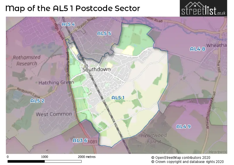
The AL5 1 Postcode shares a border with AL3 6 (ST. ALBANS, Childwickbury, Gorhambury), AL4 8 (Wheathampstead), AL4 9 (ST. ALBANS, Sandridge), AL5 2 (HARPENDEN), AL5 5 (HARPENDEN, Bower Heath) and AL5 4 (HARPENDEN).
The sector is within the post town of HARPENDEN.
AL5 1 is a postcode sector within the AL5 postcode district which is within the AL St Albans postcode area.
The Royal Mail delivery office for the AL5 1 postal sector is the Harpenden Delivery Office.
The area of the AL5 1 postcode sector is 2.33 square miles which is 6.03 square kilometres or 1,489.53 square acres.

Map of the AL5 1 Postcode Sector
Explore the AL5 1 postcode sector by using our free interactive map.
| A | L | 5 | - | 1 | X | X |
| A | L | 5 | Space | 1 | Letter | Letter |
Official List of Streets
HARPENDEN (82 Streets)
Unofficial Streets or Alternative Spellings
Wheathampstead
HARPENDEN ROAD LEASEY BRIDGE LANE BAMVILLE WOOD BEESONEND LANE BULL ROAD FERRERS LANE GREEN LANE KINGS COURT MAPLE COTTAGES MUD LANE SAINT JOHNS ROAD SAINT MICHAELS CLOSE ST ALBANS ROAD ST JOHNS COURT THE CHENNIES WALKERS COURT WESTMINSTER COURTHARPENDEN
ALZEY GARDENS ARDEN GROVE BARNFIELD ROAD CRABTREE LANE MARQUIS LANE TOPSTREET WAY WEST COMMON WEST COMMON WAYChildwickbury
AYRES END LANE HARPENDEN ROADWeather Forecast for AL5 1
Press Button to Show Forecast for Rothamsted No2
| Time Period | Icon | Description | Temperature | Rain Probability | Wind |
|---|---|---|---|---|---|
| 18:00 to 21:00 | Cloudy | 10.0°C (feels like 8.0°C) | 10.00% | SW 9 mph | |
| 21:00 to 00:00 | Partly cloudy (night) | 7.0°C (feels like 5.0°C) | 3.00% | SW 9 mph |
Press Button to Show Forecast for Rothamsted No2
| Time Period | Icon | Description | Temperature | Rain Probability | Wind |
|---|---|---|---|---|---|
| 00:00 to 03:00 | Clear night | 5.0°C (feels like 3.0°C) | 0.00% | SSW 7 mph | |
| 03:00 to 06:00 | Clear night | 4.0°C (feels like 2.0°C) | 0.00% | SSW 7 mph | |
| 06:00 to 09:00 | Sunny day | 6.0°C (feels like 3.0°C) | 0.00% | S 9 mph | |
| 09:00 to 12:00 | Partly cloudy (day) | 11.0°C (feels like 8.0°C) | 4.00% | SSW 16 mph | |
| 12:00 to 15:00 | Cloudy | 14.0°C (feels like 10.0°C) | 9.00% | SSW 16 mph | |
| 15:00 to 18:00 | Partly cloudy (day) | 14.0°C (feels like 11.0°C) | 1.00% | SSW 16 mph | |
| 18:00 to 21:00 | Sunny day | 12.0°C (feels like 10.0°C) | 0.00% | SSW 11 mph | |
| 21:00 to 00:00 | Clear night | 10.0°C (feels like 8.0°C) | 0.00% | SSE 7 mph |
Press Button to Show Forecast for Rothamsted No2
| Time Period | Icon | Description | Temperature | Rain Probability | Wind |
|---|---|---|---|---|---|
| 00:00 to 03:00 | Clear night | 8.0°C (feels like 6.0°C) | 0.00% | SSE 7 mph | |
| 03:00 to 06:00 | Clear night | 7.0°C (feels like 5.0°C) | 0.00% | SE 7 mph | |
| 06:00 to 09:00 | Sunny day | 8.0°C (feels like 6.0°C) | 1.00% | SE 7 mph | |
| 09:00 to 12:00 | Sunny day | 13.0°C (feels like 11.0°C) | 3.00% | SE 9 mph | |
| 12:00 to 15:00 | Cloudy | 15.0°C (feels like 13.0°C) | 8.00% | SSE 11 mph | |
| 15:00 to 18:00 | Cloudy | 15.0°C (feels like 13.0°C) | 11.00% | SSE 11 mph | |
| 18:00 to 21:00 | Cloudy | 14.0°C (feels like 13.0°C) | 11.00% | SSE 7 mph | |
| 21:00 to 00:00 | Partly cloudy (night) | 11.0°C (feels like 10.0°C) | 10.00% | SE 4 mph |
Press Button to Show Forecast for Rothamsted No2
| Time Period | Icon | Description | Temperature | Rain Probability | Wind |
|---|---|---|---|---|---|
| 00:00 to 03:00 | Cloudy | 10.0°C (feels like 9.0°C) | 12.00% | SE 4 mph | |
| 03:00 to 06:00 | Cloudy | 9.0°C (feels like 8.0°C) | 12.00% | SSE 4 mph | |
| 06:00 to 09:00 | Mist | 9.0°C (feels like 9.0°C) | 20.00% | NNE 4 mph | |
| 09:00 to 12:00 | Cloudy | 12.0°C (feels like 12.0°C) | 14.00% | NE 4 mph | |
| 12:00 to 15:00 | Cloudy | 15.0°C (feels like 14.0°C) | 16.00% | ENE 7 mph | |
| 15:00 to 18:00 | Cloudy | 15.0°C (feels like 15.0°C) | 18.00% | E 7 mph | |
| 18:00 to 21:00 | Cloudy | 15.0°C (feels like 13.0°C) | 14.00% | ESE 7 mph | |
| 21:00 to 00:00 | Cloudy | 12.0°C (feels like 10.0°C) | 14.00% | WNW 7 mph |
Press Button to Show Forecast for Rothamsted No2
| Time Period | Icon | Description | Temperature | Rain Probability | Wind |
|---|---|---|---|---|---|
| 00:00 to 03:00 | Overcast | 10.0°C (feels like 8.0°C) | 17.00% | WNW 9 mph | |
| 03:00 to 06:00 | Cloudy | 10.0°C (feels like 8.0°C) | 15.00% | NW 9 mph | |
| 06:00 to 09:00 | Overcast | 10.0°C (feels like 8.0°C) | 17.00% | NW 9 mph | |
| 09:00 to 12:00 | Overcast | 12.0°C (feels like 11.0°C) | 14.00% | WNW 9 mph | |
| 12:00 to 15:00 | Cloudy | 16.0°C (feels like 14.0°C) | 9.00% | NW 9 mph | |
| 15:00 to 18:00 | Partly cloudy (day) | 17.0°C (feels like 15.0°C) | 8.00% | NW 9 mph | |
| 18:00 to 21:00 | Sunny day | 15.0°C (feels like 14.0°C) | 7.00% | N 9 mph | |
| 21:00 to 00:00 | Cloudy | 12.0°C (feels like 10.0°C) | 8.00% | NNW 9 mph |
Schools and Places of Education Within the AL5 1 Postcode Sector
St Dominic Catholic Primary School
Voluntary aided school
St Dominic Catholic Primary School, HARPENDEN, Hertfordshire, AL5 1PF
Head: Miss Clare O'Sullivan
Ofsted Rating: Outstanding
Inspection: 2023-11-23 (157 days ago)
Website: Visit St Dominic Catholic Primary School Website
Phone: 01582760047
Number of Pupils: 240
The Grove Infant and Nursery School
Community school
Dark Lane, Harpenden, Hertfordshire, AL5 1QD
Head: Ms Anna Archer
Ofsted Rating: Outstanding
Inspection: 2023-11-08 (172 days ago)
Website: Visit The Grove Infant and Nursery School Website
Phone: 01582761849
Number of Pupils: 297
The Grove Junior School
Community school
Dark Lane, Harpenden, Hertfordshire, AL5 1QB
Head: Miss Lorna Urquhart
Ofsted Rating: Good
Inspection: 2022-12-08 (507 days ago)
Website: Visit The Grove Junior School Website
Phone: 01582760031
Number of Pupils: 357
House Prices in the AL5 1 Postcode Sector
| Type of Property | 2018 Average | 2018 Sales | 2017 Average | 2017 Sales | 2016 Average | 2016 Sales | 2015 Average | 2015 Sales |
|---|---|---|---|---|---|---|---|---|
| Detached | £856,480 | 41 | £911,419 | 37 | £808,151 | 53 | £845,380 | 44 |
| Semi-Detached | £611,400 | 45 | £611,364 | 29 | £616,660 | 32 | £562,465 | 23 |
| Terraced | £492,711 | 19 | £486,838 | 21 | £492,880 | 25 | £469,447 | 25 |
| Flats | £306,882 | 19 | £359,202 | 22 | £276,262 | 17 | £241,719 | 16 |
Important Postcodes AL5 1 in the Postcode Sector
AL5 1PF is the postcode for St. Dominic RC School, Southdown Road
AL5 1PL is the postcode for Harpenden Public Halls, Southdown Road
AL5 1QB is the postcode for The Grove Junior School, Dark Lane
AL5 1QD is the postcode for The Grove Infant & Nursery School, Dark Lane, and THE GROVE INFANTS AND NURSERY SCHOOL, DARK LANE, HARPENDEN
| The AL5 1 Sector is within these Local Authorities |
|
|---|---|
| The AL5 1 Sector is within these Counties |
|
| The AL5 1 Sector is within these Water Company Areas |
|