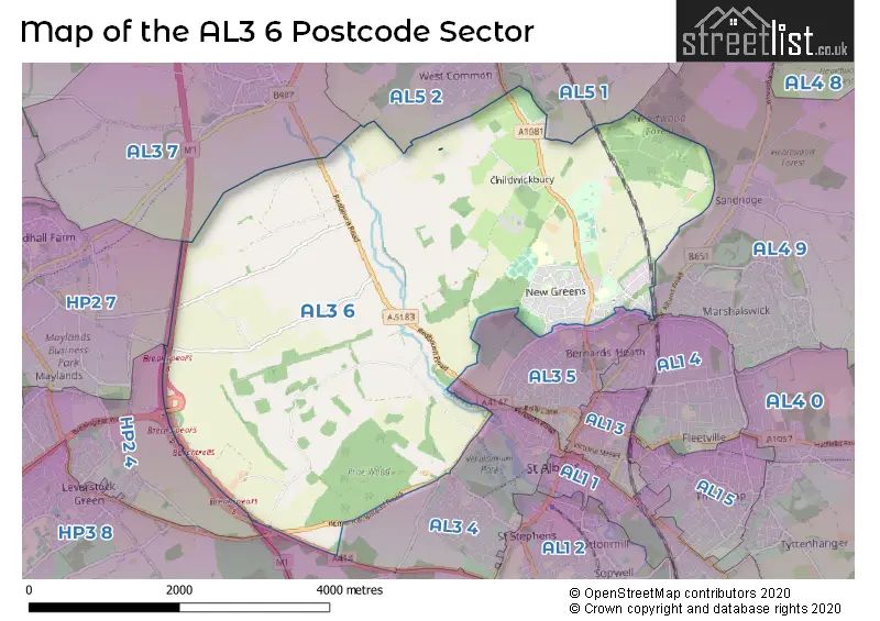
The AL3 6 postcode sector is within the county of Hertfordshire.
Did you know? According to the 2021 Census, the AL3 6 postcode sector is home to a bustling 4,579 residents!
Given that each sector allows for 400 unique postcode combinations. Letters C, I, K, M, O and V are not allowed in the last two letters of a postcode. With 161 postcodes already in use, this leaves 239 units available.
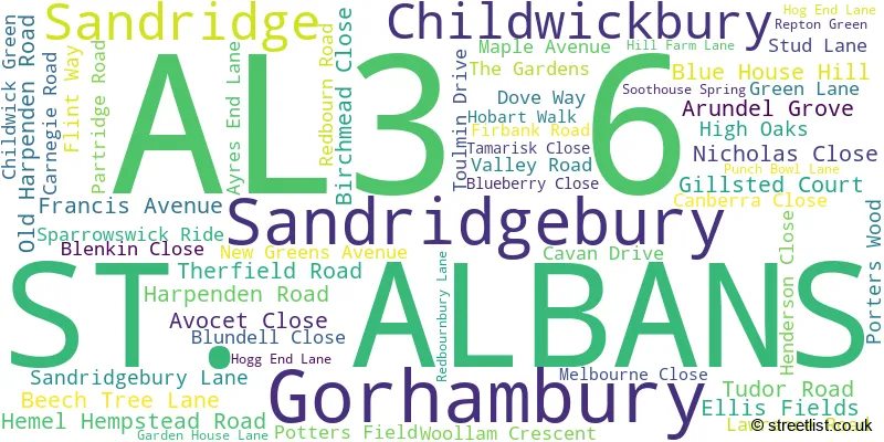
The largest settlement in the AL3 6 postal code is ST. ALBANS followed by Childwickbury, and Gorhambury.
The AL3 6 Postcode shares a border with AL1 4 (ST. ALBANS), AL2 3 (BRICKET WOOD, CHISWELL GREEN, ST ALBANS), AL3 7 (Redbourn), AL4 9 (ST. ALBANS, Sandridge), AL5 1 (HARPENDEN), AL5 2 (HARPENDEN), HP2 4 (HEMEL HEMPSTEAD, Paradise Industrial Estate), AL3 4 (ST. ALBANS, Kings Park), AL3 5 (ST. ALBANS) and HP2 7 (HEMEL HEMPSTEAD, Hemel Hempstead Industrial Estate).
The sector is within the post town of ST. ALBANS.
AL3 6 is a postcode sector within the AL3 postcode district which is within the AL St Albans postcode area.
The Royal Mail delivery office for the AL3 6 postal sector is the St. Albans Delivery Office.
The area of the AL3 6 postcode sector is 9.88 square miles which is 25.59 square kilometres or 6,324.08 square acres.
The AL3 6 postcode sector is crossed by the A414 Major A road.
The AL3 6 postcode sector is crossed by the M1 motorway.
Waterways within the AL3 6 postcode sector include the River Ver.

Map of the AL3 6 Postcode Sector
Explore the AL3 6 postcode sector by using our free interactive map.
| A | L | 3 | - | 6 | X | X |
| A | L | 3 | Space | 6 | Letter | Letter |
Official List of Streets
ST. ALBANS (47 Streets)
Childwickbury (5 Streets)
Gorhambury (1 Streets)
Sandridge (1 Streets)
Sandridgebury (1 Streets)
Unofficial Streets or Alternative Spellings
ST. ALBANS
BATCHWOOD DRIVE BEECH ROAD KING HARRY LANE ALVERTON BEAUMONT HALL LANE BEDMOND LANE BEECH BOTTOM DYKE PATH BEESONEND LANE BLUEHOUSE HILL ROUNDABOUT CASTLE MEWS CAXTON CENTRE DARWIN CLOSE FARRIDAY CLOSE GILSTED COURT GORHAMBURY DRIVE KEN DAVIES COURT LONG SPRING MERLOT MEWS PETERSFIELD SANDRIDGE PARK SCHOOL LANE SPRING VALLEY ENTERPRISE CENTRE ST MICHAELS STREET THE FERNS THE GRYPHON INDUSTRIAL PARK THE HEDGESHEMEL HEMPSTEAD,
HEMEL HEMPSTEAD ROAD PUNCH BOWL LANEWeather Forecast for AL3 6
Press Button to Show Forecast for St Albans
| Time Period | Icon | Description | Temperature | Rain Probability | Wind |
|---|---|---|---|---|---|
| 00:00 to 03:00 | Cloudy | 5.0°C (feels like 3.0°C) | 4.00% | ENE 4 mph | |
| 03:00 to 06:00 | Cloudy | 3.0°C (feels like 1.0°C) | 4.00% | NE 4 mph | |
| 06:00 to 09:00 | Cloudy | 4.0°C (feels like 1.0°C) | 4.00% | NE 4 mph | |
| 09:00 to 12:00 | Cloudy | 7.0°C (feels like 5.0°C) | 5.00% | ENE 7 mph | |
| 12:00 to 15:00 | Overcast | 9.0°C (feels like 8.0°C) | 10.00% | E 7 mph | |
| 15:00 to 18:00 | Overcast | 10.0°C (feels like 8.0°C) | 13.00% | E 7 mph | |
| 18:00 to 21:00 | Cloudy | 9.0°C (feels like 7.0°C) | 11.00% | E 7 mph | |
| 21:00 to 00:00 | Cloudy | 6.0°C (feels like 4.0°C) | 12.00% | E 7 mph |
Press Button to Show Forecast for St Albans
| Time Period | Icon | Description | Temperature | Rain Probability | Wind |
|---|---|---|---|---|---|
| 00:00 to 03:00 | Cloudy | 5.0°C (feels like 3.0°C) | 13.00% | ENE 7 mph | |
| 03:00 to 06:00 | Overcast | 5.0°C (feels like 2.0°C) | 17.00% | ENE 7 mph | |
| 06:00 to 09:00 | Cloudy | 5.0°C (feels like 2.0°C) | 24.00% | ENE 9 mph | |
| 09:00 to 12:00 | Overcast | 8.0°C (feels like 5.0°C) | 21.00% | ENE 9 mph | |
| 12:00 to 15:00 | Cloudy | 10.0°C (feels like 8.0°C) | 18.00% | E 9 mph | |
| 15:00 to 18:00 | Cloudy | 11.0°C (feels like 9.0°C) | 18.00% | E 11 mph | |
| 18:00 to 21:00 | Cloudy | 10.0°C (feels like 8.0°C) | 24.00% | ENE 9 mph | |
| 21:00 to 00:00 | Heavy rain | 9.0°C (feels like 6.0°C) | 72.00% | ENE 9 mph |
Press Button to Show Forecast for St Albans
| Time Period | Icon | Description | Temperature | Rain Probability | Wind |
|---|---|---|---|---|---|
| 00:00 to 03:00 | Heavy rain | 8.0°C (feels like 6.0°C) | 72.00% | ENE 9 mph | |
| 03:00 to 06:00 | Heavy rain | 8.0°C (feels like 6.0°C) | 75.00% | ENE 9 mph | |
| 06:00 to 09:00 | Heavy rain | 8.0°C (feels like 6.0°C) | 75.00% | E 9 mph | |
| 09:00 to 12:00 | Light rain shower (day) | 10.0°C (feels like 7.0°C) | 43.00% | E 9 mph | |
| 12:00 to 15:00 | Heavy rain shower (day) | 11.0°C (feels like 9.0°C) | 60.00% | E 11 mph | |
| 15:00 to 18:00 | Light rain shower (day) | 12.0°C (feels like 10.0°C) | 39.00% | ESE 11 mph | |
| 18:00 to 21:00 | Light rain shower (day) | 11.0°C (feels like 9.0°C) | 37.00% | SW 9 mph | |
| 21:00 to 00:00 | Clear night | 9.0°C (feels like 7.0°C) | 7.00% | SW 7 mph |
Schools and Places of Education Within the AL3 6 Postcode Sector
Margaret Wix Primary School
Community school
High Oaks, St Albans, Hertfordshire, AL3 6EL
Head: Mrs Claire Gibbs
Ofsted Rating: Good
Inspection: 2019-11-20 (1619 days ago)
Website: Visit Margaret Wix Primary School Website
Phone: 01727759232
Number of Pupils: 135
St Albans Girls' School
Academy converter
Sandridgebury Lane, St Albans, Hertfordshire, AL3 6DB
Head: Mrs Margaret Chapman
Ofsted Rating: Outstanding
Inspection: 2013-01-23 (4111 days ago)
Website: Visit St Albans Girls' School Website
Phone: 01727853134
Number of Pupils: 1419
Townsend Church of England School
Voluntary aided school
High Oaks, St Albans, Hertfordshire, AL3 6DR
Head: Mr Anthony Flack
Ofsted Rating: Good
Inspection: 2018-05-15 (2173 days ago)
Website: Visit Townsend Church of England School Website
Phone: 01727853047
Number of Pupils: 768
House Prices in the AL3 6 Postcode Sector
| Type of Property | 2018 Average | 2018 Sales | 2017 Average | 2017 Sales | 2016 Average | 2016 Sales | 2015 Average | 2015 Sales |
|---|---|---|---|---|---|---|---|---|
| Detached | £1,135,125 | 8 | £796,063 | 8 | £621,000 | 5 | £768,750 | 16 |
| Semi-Detached | £620,231 | 13 | £636,421 | 19 | £470,056 | 9 | £459,690 | 25 |
| Terraced | £446,083 | 12 | £408,698 | 16 | £514,480 | 12 | £358,050 | 20 |
| Flats | £272,500 | 5 | £267,455 | 11 | £260,581 | 24 | £207,950 | 32 |
Important Postcodes AL3 6 in the Postcode Sector
AL3 6DB is the postcode for Parks Block, St. Albans Girls School, Sandridgebury Lane, LANGUAGES BLOCK, St. Albans Girls School, Sandridgebury Lane, ST. ALBANS GIRLS SCHOOL SPECIALIST BUSINESS & ENTERPRISE ACADEMY, St. Albans Girls School, Sandridgebury Lane, SPORTS HALL, St. Albans Girls School, Sandridgebury Lane, and St. Albans Girls School, Sandridgebury Lane
AL3 6DR is the postcode for Townsend C of E (VA) Secondary School, Sparrowswick Ride, SCIENCE & ART BLOCK, Townsend C of E (VA) Secondary School, Sparrowswick Ride, DISCOVERY CENTRE, Townsend C of E (VA) Secondary School, Sparrowswick Ride, MAIN BLOCK, Townsend C of E (VA) Secondary School, Sparrowswick Ride, DT BLOCK, Townsend C of E (VA) Secondary School, Sparrowswick Ride, and SWIMMING POOL, Townsend C of E (VA) Secondary School, Sparrowswick Ride
AL3 6EJ is the postcode for Links Education Support Centre, The Centre, Woollam Crescent, and Links Academy Woollam, Woollam Crecscent
AL3 6EL is the postcode for MAIN BUILDING, Margaret Wix Primary School, High Oaks, and Margaret Wix Primary School, High Oaks
| The AL3 6 Sector is within these Local Authorities |
|
|---|---|
| The AL3 6 Sector is within these Counties |
|
| The AL3 6 Sector is within these Water Company Areas |
|