The AL3 postcode district is a postal district located in the AL St Albans postcode area with a population of 29,620 residents according to the 2021 England and Wales Census.
The area of the AL3 postcode district is 26.89 square miles which is 69.64 square kilometres or 17,208.75 acres.
Currently, the AL3 district has about 950 postcode units spread across 5 geographic postcode sectors.
Given that each sector allows for 400 unique postcode combinations, the district has a capacity of 2,000 postcodes. With 950 postcodes already in use, this leaves 1050 units available.
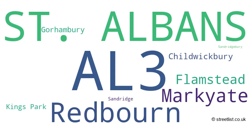
The largest settlement in the AL3 postal code is ST. ALBANS followed by Redbourn, and Markyate.
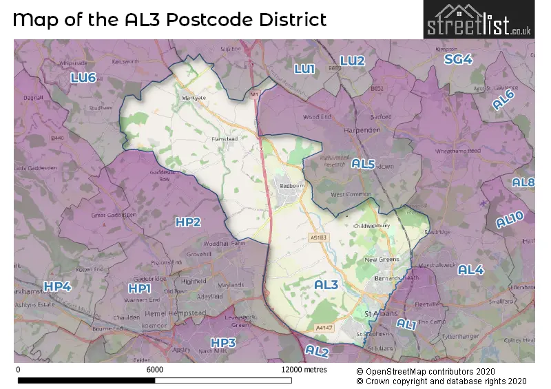
The AL3 Postcode shares a border with AL1 (ST. ALBANS), AL2 (LONDON COLNEY, BRICKET WOOD, PARK STREET), AL5 (HARPENDEN), LU1 (LUTON, Caddington, Slip End), LU6 (DUNSTABLE, Eaton Bray, Edlesborough) and HP2 (HEMEL HEMPSTEAD, Hemel Hempstead Industrial Estate, Gaddesden Row).
In the AL3 postcode district, the primary settlement is St. Albans, located in the county of Hertfordshire. Additionally, there are significant settlements in Kings Park, Childwickbury, Gorhambury, Sandridge, and Sandridgebury. The most significant post town in this district is St. Albans in Hertfordshire.
For the district AL3, we have data on 5 postcode sectors. Here's a breakdown: The sector AL3 4, covers St. Albans in Hertfordshire. The sector AL3 5, covers St. Albans in Hertfordshire. The sector AL3 6, covers St. Albans in Hertfordshire. The sector AL3 7, covers Redbourn in Hertfordshire. The sector AL3 8, covers Markyate and Flamstead in Hertfordshire.

Map of the AL3 Postcode District
Explore the AL3 postcode district by using our free interactive map.
When it comes to local government, postal geography often disregards political borders. However, for a breakdown in the AL3 District: the district mostly encompasses the St. Albans District (B) (761 postcodes), and finally, the Dacorum District (B) area (191 postcodes).
Where is the AL3 Postcode District?
The data's 'AL3' postcode district is located in St. Albans, a town in the United Kingdom. St. Albans is situated near several other towns: Harpenden is found to the North East, Hemel Hempstead is located to the South West, Pimlico is situated to the South, and Chiswell Green is found to the South East. Additionally, St. Albans is approximately 23.13 miles away from the center of London.
The district is within the post town of ST. ALBANS.
The sector has postcodes within the nation of England.
The AL3 Postcode District is in the Hertfordshire region of Bedfordshire and Hertfordshire within the East of England.
Weather Forecast for AL3
Press Button to Show Forecast for Rothamsted
| Time Period | Icon | Description | Temperature | Rain Probability | Wind |
|---|---|---|---|---|---|
| 18:00 to 21:00 | Cloudy | 19.0°C (feels like 17.0°C) | 3.00% | E 9 mph | |
| 21:00 to 00:00 | Clear night | 15.0°C (feels like 13.0°C) | 0.00% | E 7 mph |
Press Button to Show Forecast for Rothamsted
| Time Period | Icon | Description | Temperature | Rain Probability | Wind |
|---|---|---|---|---|---|
| 00:00 to 03:00 | Cloudy | 13.0°C (feels like 12.0°C) | 3.00% | E 7 mph | |
| 03:00 to 06:00 | Cloudy | 13.0°C (feels like 12.0°C) | 3.00% | E 7 mph | |
| 06:00 to 09:00 | Cloudy | 14.0°C (feels like 13.0°C) | 4.00% | E 7 mph | |
| 09:00 to 12:00 | Cloudy | 19.0°C (feels like 18.0°C) | 4.00% | E 9 mph | |
| 12:00 to 15:00 | Partly cloudy (day) | 23.0°C (feels like 21.0°C) | 1.00% | ESE 11 mph | |
| 15:00 to 18:00 | Partly cloudy (day) | 23.0°C (feels like 21.0°C) | 3.00% | ESE 9 mph | |
| 18:00 to 21:00 | Cloudy | 21.0°C (feels like 20.0°C) | 7.00% | ESE 7 mph | |
| 21:00 to 00:00 | Cloudy | 17.0°C (feels like 16.0°C) | 5.00% | S 7 mph |
Press Button to Show Forecast for Rothamsted
| Time Period | Icon | Description | Temperature | Rain Probability | Wind |
|---|---|---|---|---|---|
| 00:00 to 03:00 | Partly cloudy (night) | 14.0°C (feels like 13.0°C) | 12.00% | SSW 7 mph | |
| 03:00 to 06:00 | Cloudy | 13.0°C (feels like 12.0°C) | 7.00% | S 7 mph | |
| 06:00 to 09:00 | Overcast | 13.0°C (feels like 11.0°C) | 11.00% | SSW 9 mph | |
| 09:00 to 12:00 | Overcast | 15.0°C (feels like 13.0°C) | 10.00% | S 11 mph | |
| 12:00 to 15:00 | Cloudy | 17.0°C (feels like 14.0°C) | 10.00% | S 13 mph | |
| 15:00 to 18:00 | Cloudy | 17.0°C (feels like 14.0°C) | 16.00% | S 16 mph | |
| 18:00 to 21:00 | Overcast | 16.0°C (feels like 14.0°C) | 28.00% | SSE 13 mph | |
| 21:00 to 00:00 | Heavy rain | 15.0°C (feels like 13.0°C) | 86.00% | SSE 11 mph |
Press Button to Show Forecast for Rothamsted
| Time Period | Icon | Description | Temperature | Rain Probability | Wind |
|---|---|---|---|---|---|
| 00:00 to 03:00 | Heavy rain | 14.0°C (feels like 12.0°C) | 82.00% | SSE 9 mph | |
| 03:00 to 06:00 | Light rain | 13.0°C (feels like 11.0°C) | 55.00% | SSE 9 mph | |
| 06:00 to 09:00 | Light rain | 12.0°C (feels like 11.0°C) | 54.00% | S 7 mph | |
| 09:00 to 12:00 | Cloudy | 13.0°C (feels like 12.0°C) | 23.00% | S 11 mph | |
| 12:00 to 15:00 | Light rain shower (day) | 16.0°C (feels like 13.0°C) | 39.00% | S 13 mph | |
| 15:00 to 18:00 | Light rain shower (day) | 16.0°C (feels like 13.0°C) | 33.00% | S 13 mph | |
| 18:00 to 21:00 | Partly cloudy (day) | 15.0°C (feels like 13.0°C) | 9.00% | S 11 mph | |
| 21:00 to 00:00 | Partly cloudy (night) | 13.0°C (feels like 11.0°C) | 5.00% | SSE 9 mph |
Press Button to Show Forecast for Rothamsted
| Time Period | Icon | Description | Temperature | Rain Probability | Wind |
|---|---|---|---|---|---|
| 00:00 to 03:00 | Partly cloudy (night) | 11.0°C (feels like 10.0°C) | 5.00% | SSE 9 mph | |
| 03:00 to 06:00 | Cloudy | 11.0°C (feels like 9.0°C) | 8.00% | SSE 7 mph | |
| 06:00 to 09:00 | Cloudy | 11.0°C (feels like 9.0°C) | 8.00% | SSE 9 mph | |
| 09:00 to 12:00 | Partly cloudy (day) | 13.0°C (feels like 11.0°C) | 10.00% | S 11 mph | |
| 12:00 to 15:00 | Light rain shower (day) | 15.0°C (feels like 13.0°C) | 33.00% | S 13 mph | |
| 15:00 to 18:00 | Light rain shower (day) | 16.0°C (feels like 13.0°C) | 32.00% | S 13 mph | |
| 18:00 to 21:00 | Sunny day | 15.0°C (feels like 13.0°C) | 8.00% | S 11 mph | |
| 21:00 to 00:00 | Clear night | 12.0°C (feels like 10.0°C) | 3.00% | S 7 mph |
| Postcode Sector | Delivery Office |
|---|---|
| AL3 4 | St. Albans Delivery Office |
| AL3 5 | St. Albans Delivery Office |
| AL3 6 | St. Albans Delivery Office |
| AL3 7 | St. Albans Delivery Office |
| AL3 8 | St. Albans Delivery Office |
| AL3 7 | Redbourn Scale Payment Delivery Office |
| A | L | 3 | - | X | X | X |
| A | L | 3 | Space | Numeric | Letter | Letter |
Tourist Attractions within the AL3 Postcode Area
We found 1 visitor attractions within the AL3 postcode area
| Redbourn Village Museum |
|---|
| Museums & Art Galleries |
| Museum and / or Art Gallery |
| View Redbourn Village Museum on Google Maps |
Current Monthly Rental Prices
| # Bedrooms | Min Price | Max Price | Avg Price |
|---|---|---|---|
| £3,750 | £3,750 | £3,750 | |
| 1 | £1,400 | £1,400 | £1,400 |
| 2 | £1,195 | £3,100 | £1,818 |
| 3 | £1,595 | £4,333 | £2,236 |
| 4 | £1,750 | £8,450 | £3,891 |
Current House Prices
| # Bedrooms | Min Price | Max Price | Avg Price |
|---|---|---|---|
| 3 | £775,000 | £1,500,000 | £1,137,500 |
| 4 | £1,450,000 | £2,000,000 | £1,717,857 |
| 5 | £1,495,000 | £4,250,000 | £2,239,545 |
| 6 | £2,500,000 | £4,500,000 | £3,280,000 |
| 10 | £4,990,000 | £4,990,000 | £4,990,000 |
Estate Agents who Operate in the AL3 District
| Logo | Name | Brand Name | Address | Contact Number | Total Properties |
|---|---|---|---|---|---|
 | Village & Country | Ashtons | 48 High Street, Redbourn, AL3 7LN | 01582 377365 | 39 |
 | Redbourn | Fine & Country | 51 High Street Redbourn AL3 7LW | 01582 793116 | 16 |
 | St. Albans | Frost's Estate Agents | 4 Chequer Street, St. Albans, AL1 3XZ | 01727 649757 | 14 |
 | Harpenden | Frost's Estate Agents | 6a Leyton Road, Harpenden, AL5 2TL | 01582 377376 | 12 |
 | Marshalswick | Cassidy & Tate | 59 The Quadrant Marshalswick St. Albans AL4 9RD | 01727 832383 | 9 |
Yearly House Price Averages for the AL3 Postcode District
| Type of Property | 2018 Average | 2018 Sales | 2017 Average | 2017 Sales | 2016 Average | 2016 Sales | 2015 Average | 2015 Sales |
|---|---|---|---|---|---|---|---|---|
| Detached | £897,987 | 75 | £822,504 | 98 | £789,223 | 95 | £740,013 | 111 |
| Semi-Detached | £628,846 | 91 | £558,889 | 132 | £607,081 | 105 | £516,581 | 129 |
| Terraced | £505,962 | 163 | £508,634 | 147 | £488,904 | 180 | £449,708 | 241 |
| Flats | £310,483 | 78 | £315,019 | 58 | £298,443 | 105 | £252,167 | 96 |