The M11 postcode district is a postal district located in the M Manchester postcode area with a population of 24,400 residents according to the 2021 England and Wales Census.
The area of the M11 postcode district is 2.41 square miles which is 6.25 square kilometres or 1,543.98 acres.
Currently, the M11 district has about 747 postcode units spread across 4 geographic postcode sectors.
Given that each sector allows for 400 unique postcode combinations, the district has a capacity of 1,600 postcodes. With 747 postcodes already in use, this leaves 853 units available.
The largest settlements in the M11 postal code are MANCHESTER and Openshaw.
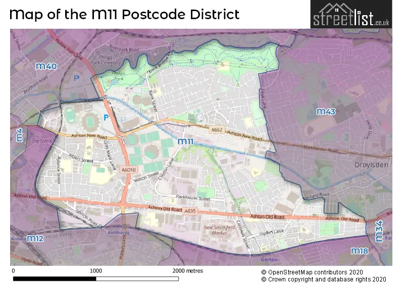
The M11 Postcode shares a border with M40 (MANCHESTER, Moston), M34 (Denton, Audenshaw), M12 (MANCHESTER, Longsight, Ardwick) and M43 (Droylsden).
The primary settlement in the M11 postcode district is Manchester, located in Greater Manchester, England. Other significant settlements in the district include Openshaw and Clayton. The main post town associated with the M11 postcode district is Manchester.
For the district M11, we have data on 5 postcode sectors. Here's a breakdown: The sector M11 0 is non-geographic. It's often designated for PO Boxes, large organisations, or special services. The sector M11 1, covers Manchester and Openshaw in Greater Manchester. The sector M11 2, covers Manchester and Openshaw in Greater Manchester. The sector M11 3, covers Manchester in Greater Manchester. The sector M11 4, covers Manchester in Greater Manchester.


Map of the M11 Postcode District
Explore the M11 postcode district by using our free interactive map.
When it comes to local government, postal geography often disregards political borders. However, for a breakdown in the M11 District: the district mostly encompasses the Manchester District (B) area with a total of 750 postcodes.
Recent House Sales in M11
| Date | Price | Address |
|---|---|---|
| 03/10/2023 | £125,000 | Elysian Street, Openshaw, Manchester, M11 2GG |
| 03/10/2023 | £138,000 | Bosworth Street, Manchester, M11 3AW |
| 02/10/2023 | £235,000 | Doric Close, Manchester, M11 3QL |
| 22/09/2023 | £150,000 | Bosworth Street, Manchester, M11 3AW |
| 01/09/2023 | £228,000 | Toxteth Street, Manchester, M11 1EQ |
| 31/08/2023 | £286,000 | Malford Street, Manchester, M11 1LZ |
| 29/08/2023 | £165,000 | Old Lane, Manchester, M11 1DE |
| 25/08/2023 | £125,000 | Dargai Street, Manchester, M11 4PW |
| 11/08/2023 | £185,000 | Ashton New Road, Manchester, M11 4GT |
| 11/08/2023 | £206,000 | Stuart Street, Manchester, M11 4DU |
Weather Forecast for M11
Press Button to Show Forecast for Clayton (Greater Manchester)
| Time Period | Icon | Description | Temperature | Rain Probability | Wind |
|---|---|---|---|---|---|
| 09:00 to 12:00 | Cloudy | 8.0°C (feels like 5.0°C) | 6.00% | ENE 9 mph | |
| 12:00 to 15:00 | Cloudy | 10.0°C (feels like 8.0°C) | 7.00% | ENE 9 mph | |
| 15:00 to 18:00 | Light rain | 10.0°C (feels like 7.0°C) | 47.00% | ENE 9 mph | |
| 18:00 to 21:00 | Cloudy | 9.0°C (feels like 6.0°C) | 13.00% | ENE 9 mph | |
| 21:00 to 00:00 | Cloudy | 7.0°C (feels like 5.0°C) | 5.00% | NE 7 mph |
Press Button to Show Forecast for Clayton (Greater Manchester)
| Time Period | Icon | Description | Temperature | Rain Probability | Wind |
|---|---|---|---|---|---|
| 00:00 to 03:00 | Cloudy | 6.0°C (feels like 3.0°C) | 4.00% | NE 7 mph | |
| 03:00 to 06:00 | Cloudy | 5.0°C (feels like 3.0°C) | 7.00% | NNE 7 mph | |
| 06:00 to 09:00 | Light rain | 6.0°C (feels like 3.0°C) | 44.00% | N 9 mph | |
| 09:00 to 12:00 | Light rain | 7.0°C (feels like 5.0°C) | 46.00% | NNW 7 mph | |
| 12:00 to 15:00 | Light rain | 9.0°C (feels like 7.0°C) | 46.00% | NW 9 mph | |
| 15:00 to 18:00 | Cloudy | 10.0°C (feels like 8.0°C) | 13.00% | WNW 11 mph | |
| 18:00 to 21:00 | Sunny day | 10.0°C (feels like 8.0°C) | 5.00% | W 9 mph | |
| 21:00 to 00:00 | Clear night | 7.0°C (feels like 5.0°C) | 3.00% | WSW 7 mph |
Press Button to Show Forecast for Clayton (Greater Manchester)
| Time Period | Icon | Description | Temperature | Rain Probability | Wind |
|---|---|---|---|---|---|
| 00:00 to 03:00 | Partly cloudy (night) | 6.0°C (feels like 3.0°C) | 1.00% | SSW 7 mph | |
| 03:00 to 06:00 | Clear night | 4.0°C (feels like 2.0°C) | 2.00% | SSE 7 mph | |
| 06:00 to 09:00 | Partly cloudy (day) | 6.0°C (feels like 3.0°C) | 3.00% | SSE 7 mph | |
| 09:00 to 12:00 | Partly cloudy (day) | 10.0°C (feels like 8.0°C) | 2.00% | S 11 mph | |
| 12:00 to 15:00 | Overcast | 13.0°C (feels like 10.0°C) | 11.00% | S 13 mph | |
| 15:00 to 18:00 | Cloudy | 13.0°C (feels like 11.0°C) | 8.00% | S 13 mph | |
| 18:00 to 21:00 | Cloudy | 13.0°C (feels like 10.0°C) | 10.00% | SSE 11 mph | |
| 21:00 to 00:00 | Partly cloudy (night) | 11.0°C (feels like 8.0°C) | 3.00% | SSE 9 mph |
Press Button to Show Forecast for Clayton (Greater Manchester)
| Time Period | Icon | Description | Temperature | Rain Probability | Wind |
|---|---|---|---|---|---|
| 00:00 to 03:00 | Clear night | 9.0°C (feels like 7.0°C) | 3.00% | SE 9 mph | |
| 03:00 to 06:00 | Partly cloudy (night) | 8.0°C (feels like 6.0°C) | 2.00% | SE 9 mph | |
| 06:00 to 09:00 | Sunny day | 9.0°C (feels like 6.0°C) | 3.00% | ESE 9 mph | |
| 09:00 to 12:00 | Sunny day | 12.0°C (feels like 10.0°C) | 4.00% | ESE 11 mph | |
| 12:00 to 15:00 | Partly cloudy (day) | 15.0°C (feels like 12.0°C) | 8.00% | SE 13 mph | |
| 15:00 to 18:00 | Partly cloudy (day) | 16.0°C (feels like 13.0°C) | 9.00% | SE 11 mph | |
| 18:00 to 21:00 | Partly cloudy (day) | 15.0°C (feels like 13.0°C) | 8.00% | ESE 11 mph | |
| 21:00 to 00:00 | Cloudy | 12.0°C (feels like 11.0°C) | 7.00% | E 9 mph |
Where is the M11 Postcode District?
The data provided indicates that the M11 postcode district is in Manchester. It is located in the North East direction from Oldham, with a distance of approximately 5.54 miles. The district is also in close proximity to other towns like Dukinfield in the East (4.26 miles), Salford in the West (4.26 miles), Stockport in the South (4.83 miles), and Sale in the South West (7.12 miles). Furthermore, the data reveals that the distance from the district to the center of London is approximately 161.56 miles.
The district is within the post town of MANCHESTER.
The sector has postcodes within the nation of England.
The M11 Postcode District is covers the following regions.
- Manchester - Greater Manchester - North West (England)
- Greater Manchester South East - Greater Manchester - North West (England)
| Postcode Sector | Delivery Office |
|---|---|
| M11 1 | Openshaw Delivery Office |
| M11 2 | Openshaw Delivery Office |
| M11 3 | Openshaw Delivery Office |
| M11 4 | Openshaw Delivery Office |
| M | 1 | 1 | - | X | X | X |
| M | 1 | 1 | Space | Numeric | Letter | Letter |
Current Monthly Rental Prices
| # Bedrooms | Min Price | Max Price | Avg Price |
|---|---|---|---|
| 1 | £646 | £2,668 | £1,346 |
| 2 | £850 | £1,200 | £1,015 |
| 3 | £900 | £2,781 | £1,583 |
| 4 | £1,300 | £1,300 | £1,300 |
| 6 | £2,500 | £2,500 | £2,500 |
Current House Prices
| # Bedrooms | Min Price | Max Price | Avg Price |
|---|---|---|---|
| 1 | £55,000 | £129,950 | £99,150 |
| 2 | £85,000 | £400,000 | £182,306 |
| 3 | £150,000 | £975,000 | £256,042 |
| 4 | £280,000 | £375,000 | £326,667 |
Estate Agents who Operate in the M11 District
| Logo | Name | Brand Name | Address | Contact Number | Total Properties |
|---|---|---|---|---|---|
 | Droylsden | Edward Mellor Ltd | 136 Market Street, Droylsden, M43 7AA | 0161 524 2800 | 9 |
 | Manchester | The Good Estate Agency | The Good Estate Agency, 10th Floor, 3 Hardman Street, Spinningfields, Manchester, M3 3HF | 0161 524 3447 | 6 |
 | Manchester Southern Gateway | Thornley Groves | 25 Whitworth Street West, Manchester, M1 5ND | 0161 241 5875 | 4 |
 | Manchester | Strike | Nationwide | 0161 524 4429 | 4 |
 | Trafford Park | Knight Knox | Quay West at MediaCityUK Trafford Wharf Road Trafford Park Manchester M17 1HH | 0161 524 8532 | 4 |
| Type of Property | 2018 Average | 2018 Sales | 2017 Average | 2017 Sales | 2016 Average | 2016 Sales | 2015 Average | 2015 Sales |
|---|---|---|---|---|---|---|---|---|
| Detached | £177,189 | 9 | £181,792 | 12 | £160,374 | 20 | £177,501 | 22 |
| Semi-Detached | £164,586 | 102 | £138,066 | 99 | £143,767 | 73 | £130,112 | 70 |
| Terraced | £121,036 | 162 | £111,647 | 153 | £106,366 | 164 | £109,156 | 177 |
| Flats | £129,721 | 31 | £114,533 | 54 | £106,562 | 36 | £101,846 | 30 |